

Houston weather: Storms possible for your Tuesday
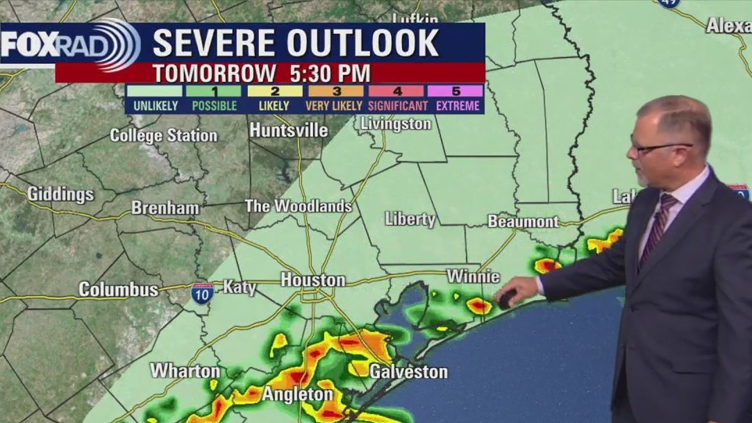
Tuesday ramps up with a cold front fueling a decent chance for afternoon scattered thunderstorms, especially south of Houston. Rain will most likely hold off until after 1pm, so prepare for the chance for rain after school Tuesday. Unseasonably muggy air will surge in Tuesday, so as another front moves in, it will have plenty of moisture to work with. We should get a decent cool-down for Wednesday afternoon.
Tuesday ramps up with a cold front fueling a decent chance for afternoon scattered thunderstorms, especially south of Houston. Rain will most likely hold off until after 1pm, so prepare for the chance for rain after school Tuesday. Unseasonably muggy air will surge in Tuesday, so as another front moves in, it will have plenty of moisture to work with. We should get a decent cool-down for Wednesday afternoon.
Houston weather: Storms possible for your Tuesday
Tuesday ramps up with a cold front fueling a decent chance for afternoon scattered thunderstorms, especially south of Houston. Rain will most likely hold off until after 1pm, so prepare for the chance for rain after school Tuesday. Unseasonably muggy air will surge in Tuesday, so as another front moves in, it will have plenty of moisture to work with. We should get a decent cool-down for Wednesday afternoon.
Tuesday ramps up with a cold front fueling a decent chance for afternoon scattered thunderstorms, especially south of Houston. Rain will most likely hold off until after 1pm, so prepare for the chance for rain after school Tuesday. Unseasonably muggy air will surge in Tuesday, so as another front moves in, it will have plenty of moisture to work with. We should get a decent cool-down for Wednesday afternoon.
Tropical Weather Update - Monitoring Invest 98L
Recent satellite wind data indicate the tropical wave (Invest 98L) located over the eastern Caribbean Sea still lacks a closed circulation, but continues to produce a concentrated area of showers and thunderstorms. Compared to yesterday, surface observations suggest the circulation is gradually becoming better defined, and environmental conditions are forecast to become a little more conducive for development as the system slows its forward motion. A tropical depression or storm is now likely to form over the next day or two as it moves into the central Caribbean Sea.
Recent satellite wind data indicate the tropical wave (Invest 98L) located over the eastern Caribbean Sea still lacks a closed circulation, but continues to produce a concentrated area of showers and thunderstorms. Compared to yesterday, surface observations suggest the circulation is gradually becoming better defined, and environmental conditions are forecast to become a little more conducive for development as the system slows its forward motion. A tropical depression or storm is now likely to form over the next day or two as it moves into the central Caribbean Sea.
SPOT X Satellite Messenger | Hurricane Gear Test
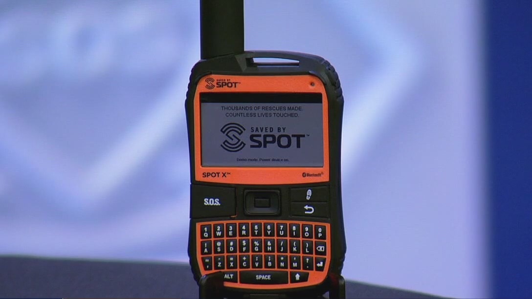
Our phones are needed during storms to keep us connected and informed. FOX 26 Meteorologist John Dawson shows us the Spot X Satellite Messenger that can keep us connected even is cell towers aren't working.
Our phones are needed during storms to keep us connected and informed. FOX 26 Meteorologist John Dawson shows us the Spot X Satellite Messenger that can keep us connected even is cell towers aren't working.


Houston weather: Warm Monday afternoon, storms possible Tuesday
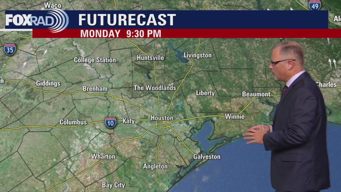
A chilly start to Monday before things warm up to the 90s. Tuesday ramps up with a cold front which could bring a decent chance for afternoon scattered storms.
A chilly start to Monday before things warm up to the 90s. Tuesday ramps up with a cold front which could bring a decent chance for afternoon scattered storms.
Houston weather: Chilly morning, warm Monday afternoon
Stepping out the door this morning, the temperature is a little chilly withs lows in the 50s and 60s. However, as we move into the afternoon it'll warm up to the recent highs of 90s with some sunshine.
Stepping out the door this morning, the temperature is a little chilly withs lows in the 50s and 60s. However, as we move into the afternoon it'll warm up to the recent highs of 90s with some sunshine.
Houston weather: October 19 overnight forecast
The FOX 26 Weekend Team provides the latest local, regional, and national news events of the day.
The FOX 26 Weekend Team provides the latest local, regional, and national news events of the day.


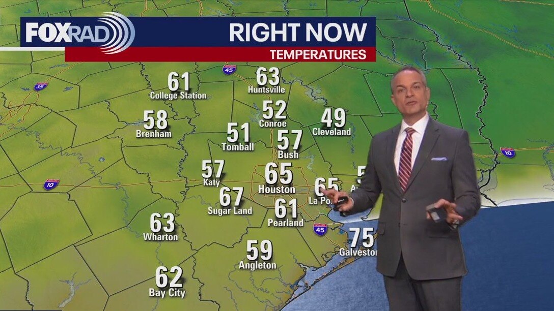
Houston weather: Cool start, rain chances for the new week
Monday morning should be the coolest of next week, with upper 50s across the region.
Monday morning should be the coolest of next week, with upper 50s across the region.

Houston weather: October 19 evening forecast
Very dry air along with north breezes keep high risk for fires across our area and much of Texas.
Very dry air along with north breezes keep high risk for fires across our area and much of Texas.

Tropical Weather Update - October 19, 2025
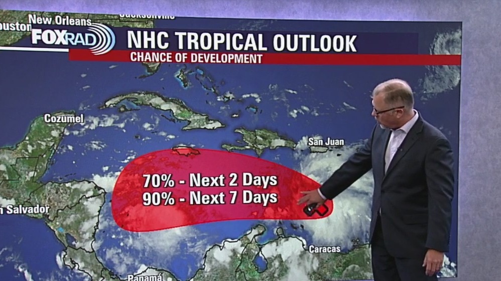
Near the Windward Islands and the Caribbean Sea (AL98): Recent satellite wind data and surface observations indicate the tropical wave (Invest 98L) currently crossing the Windward Islands still lacks a closed circulation. However both radar and satellite images indicate the associated shower and thunderstorm activity is starting to show signs of organization. The system is still moving quickly westward at 20 to 25 mph and environmental conditions are forecast to become more favorable as it slows down in the central Caribbean Sea by the middle of this week. A tropical depression is likely to form by the middle to latter portion of this week in the central Caribbean Sea.
Near the Windward Islands and the Caribbean Sea (AL98): Recent satellite wind data and surface observations indicate the tropical wave (Invest 98L) currently crossing the Windward Islands still lacks a closed circulation. However both radar and satellite images indicate the associated shower and thunderstorm activity is starting to show signs of organization. The system is still moving quickly westward at 20 to 25 mph and environmental conditions are forecast to become more favorable as it slows down in the central Caribbean Sea by the middle of this week. A tropical depression is likely to form by the middle to latter portion of this week in the central Caribbean Sea.


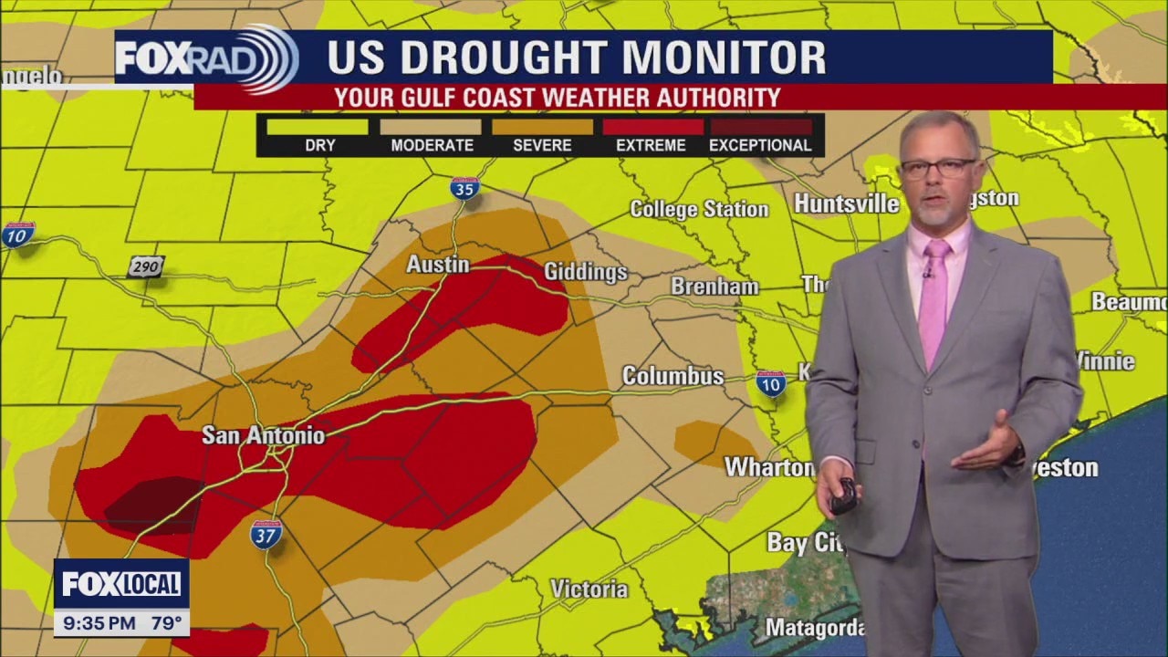
Houston weather: Dry conditions following cold front
Very dry air along with north breezes on Sunday mean a higher risk for fires across our area and much of Texas.
Very dry air along with north breezes on Sunday mean a higher risk for fires across our area and much of Texas.

Houston weather: Sunday, Oct. 19 morning forecast
A look at when we can expect the fall cool-down in the Houston area.
A look at when we can expect the fall cool-down in the Houston area.

Hurricane Gear Test: Devos Lightranger
You need to have a battery-powered light in your hurricane kit. FOX 26 Meteorologist John Dawson is taking a look at a rechargeable one.
You need to have a battery-powered light in your hurricane kit. FOX 26 Meteorologist John Dawson is taking a look at a rechargeable one.

FOX 26 Houston Weather Forecast
The weather forecast for today is mostly sunny and hot, with highs in the mid to upper 90s, and there is a possibility of isolated afternoon storms.
The weather forecast for today is mostly sunny and hot, with highs in the mid to upper 90s, and there is a possibility of isolated afternoon storms.

Tropical Weather Update - July 24, 2023
Don has now become a post-tropical cyclone and is set to completely fall apart by tomorrow in the north central Atlantic. However, there are two tropical waves being watched for development in the Atlantic. They both have only a slim shot for development as they move west over the next 2-7 days. Gulf of Mexico and the Caribbean Sea remain quiet for now with Saharan dust bringing in drier air which will help to limit tropical cyclone development.
Don has now become a post-tropical cyclone and is set to completely fall apart by tomorrow in the north central Atlantic. However, there are two tropical waves being watched for development in the Atlantic. They both have only a slim shot for development as they move west over the next 2-7 days. Gulf of Mexico and the Caribbean Sea remain quiet for now with Saharan dust bringing in drier air which will help to limit tropical cyclone development.

FOX 26 Houston Weather Forecast
After 16 days straight of heat advisories, we are finally getting a break. It will still be hot this week with temperatures close to 100 but the humidity will be a little lower to keep heat index values below advisory criteria. Look for isolated showers and storms every afternoon and evening with a few heavy downpours possible. The Saharan Dust is building in to SE Texas but is not expected to cause major air quality issues at this point. But if you have asthma or other respiratory problems, the dust may be a bit of a nuisance and irritant. But most folks will not be impacted.
After 16 days straight of heat advisories, we are finally getting a break. It will still be hot this week with temperatures close to 100 but the humidity will be a little lower to keep heat index values below advisory criteria. Look for isolated showers and storms every afternoon and evening with a few heavy downpours possible. The Saharan Dust is building in to SE Texas but is not expected to cause major air quality issues at this point. But if you have asthma or other respiratory problems, the dust may be a bit of a nuisance and irritant. But most folks will not be impacted.

FOX 26 Houston Weather Forecast
The weather forecast for today shows it will be partly cloudy and hot. The temperature is expected to reach the upper 90s during the day. There is a possibility of isolated late afternoon storms occurring.
The weather forecast for today shows it will be partly cloudy and hot. The temperature is expected to reach the upper 90s during the day. There is a possibility of isolated late afternoon storms occurring.

FOX 26 Houston Weather Forecast
HEAT ADVISORY remains in place until 8 PM for the southern two-thirds of the SE Texas area including Houston. Heat index values near 108 are still possible this evening which is still in the danger zone. So make sure you are drinking plenty of water, taking it easy in the heat and avoiding strenuous activity during the hottest part of the day. The good news is that heat advisories are not expected for Tuesday. This is due to the fact that Saharan dust is expected to build into the area Tuesday and Wednesday which will mix in some drier air. Temperatures will still be a bit above average the rest of this week in the upper 90s during the afternoon and near 80 overnight. Isolated afternoon and evening storms should stick around through this weekend. Don is no longer a tropical cyclone but two additional tropical waves have a low shot for development in the Atlantic.
HEAT ADVISORY remains in place until 8 PM for the southern two-thirds of the SE Texas area including Houston. Heat index values near 108 are still possible this evening which is still in the danger zone. So make sure you are drinking plenty of water, taking it easy in the heat and avoiding strenuous activity during the hottest part of the day. The good news is that heat advisories are not expected for Tuesday. This is due to the fact that Saharan dust is expected to build into the area Tuesday and Wednesday which will mix in some drier air. Temperatures will still be a bit above average the rest of this week in the upper 90s during the afternoon and near 80 overnight. Isolated afternoon and evening storms should stick around through this weekend. Don is no longer a tropical cyclone but two additional tropical waves have a low shot for development in the Atlantic.

FOX 26 Houston Weather Forecast
Parts of the Houston area may need a Heat Advisory for Monday but it will not be widespread. That is good news that Southeast Texas is seeing a slight drop in temperatures. Mostly that is because the "heat dome" is further west allowing for more clouds and pop up afternoon thunderstorms. Look for a round of Saharan dust to put some haze in the Houston skies on Tuesday and Wednesday.
Parts of the Houston area may need a Heat Advisory for Monday but it will not be widespread. That is good news that Southeast Texas is seeing a slight drop in temperatures. Mostly that is because the "heat dome" is further west allowing for more clouds and pop up afternoon thunderstorms. Look for a round of Saharan dust to put some haze in the Houston skies on Tuesday and Wednesday.

FOX 26 Houston Weather Forecast
Make sure you are drinking plenty of water, taking it easy in the heat and avoiding strenuous activity during the hottest part of the day. The good news is that heat advisories are not expected for Tuesday. This is due to the fact that Saharan dust is expected to build into the area Tuesday and Wednesday which will mix in some drier air. Temperatures will still be a bit above average the rest of this week in the upper 90s during the afternoon and near 80 overnight. Isolated afternoon and evening storms should stick around through this weekend. Don is no longer a tropical cyclone but two additional tropical waves have a low shot for development in the Atlantic.
Make sure you are drinking plenty of water, taking it easy in the heat and avoiding strenuous activity during the hottest part of the day. The good news is that heat advisories are not expected for Tuesday. This is due to the fact that Saharan dust is expected to build into the area Tuesday and Wednesday which will mix in some drier air. Temperatures will still be a bit above average the rest of this week in the upper 90s during the afternoon and near 80 overnight. Isolated afternoon and evening storms should stick around through this weekend. Don is no longer a tropical cyclone but two additional tropical waves have a low shot for development in the Atlantic.