


Wednesday evening weather forecast with Meteorologist John Dawson
Southeast Texas will see a quiet weather pattern over the next few days. Air quality will be a concern for some with an Ozone Action Day for Houston on Thursday. The weekend will see a few stray showers with warm afternoons. Expect the 90s to return for most of the area at the start of next week.
Southeast Texas will see a quiet weather pattern over the next few days. Air quality will be a concern for some with an Ozone Action Day for Houston on Thursday. The weekend will see a few stray showers with warm afternoons. Expect the 90s to return for most of the area at the start of next week.

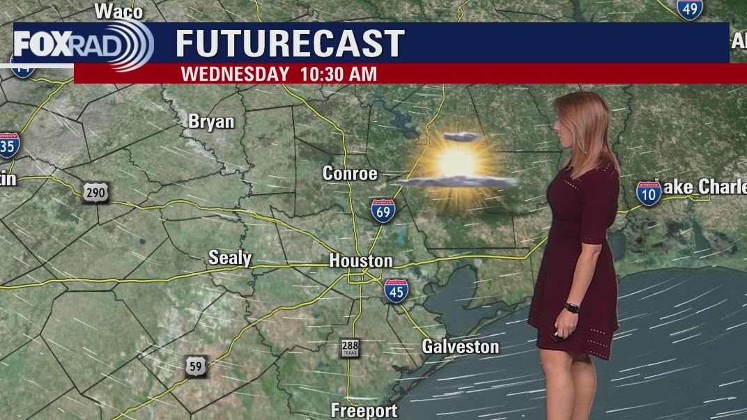
Wednesday afternoon weather forecast
Enjoy this wonderful Wednesday weather with low humidity, moderate temperatures and sunshine. A more humid Gulf breeze will return tomorrow and that will begin a warming trend for late this week through much of next week. Lows will remain stuck in the low 70s with highs in the upper 80s. There aren't any major storm chances in sight, but a few showers will be possible this weekend.
Enjoy this wonderful Wednesday weather with low humidity, moderate temperatures and sunshine. A more humid Gulf breeze will return tomorrow and that will begin a warming trend for late this week through much of next week. Lows will remain stuck in the low 70s with highs in the upper 80s. There aren't any major storm chances in sight, but a few showers will be possible this weekend.

Wednesday morning weather forecast
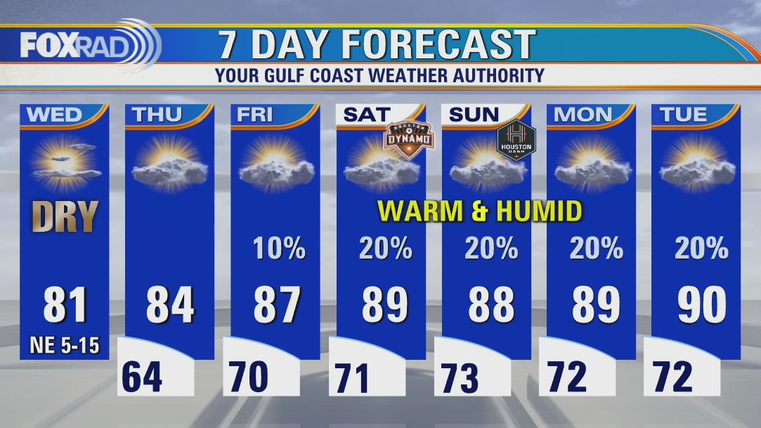
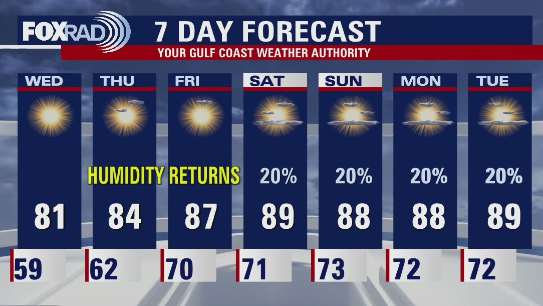
Temperatures will be cool tonight with most dropping off into the 50s. Low humidity and sunshine will be the story tomorrow with highs in the low 80s. Humidity will again be on the rise late week with temperatures topping out in the upper 80s by Friday afternoon.
Temperatures will be cool tonight with most dropping off into the 50s. Low humidity and sunshine will be the story tomorrow with highs in the low 80s. Humidity will again be on the rise late week with temperatures topping out in the upper 80s by Friday afternoon.

Tuesday evening weather forecast
Temperatures will be cool tonight with most dropping off into the 50s. Low humidity and sunshine will be the story tomorrow with highs in the low 80s. Humidity will again be on the rise late week with temperatures topping out in the upper 80s by Friday afternoon.
Temperatures will be cool tonight with most dropping off into the 50s. Low humidity and sunshine will be the story tomorrow with highs in the low 80s. Humidity will again be on the rise late week with temperatures topping out in the upper 80s by Friday afternoon.

Cold front brings heavy storms to Houston area, leaves thousands without power
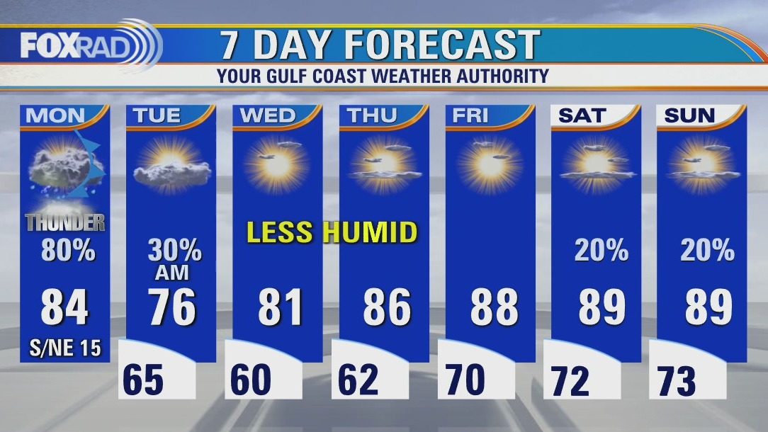
A cold front that moved into the Houston area on Monday afternoon produced scattered heavy storms and even a couple of severe storms. It also left thousands without power in the area.
A cold front that moved into the Houston area on Monday afternoon produced scattered heavy storms and even a couple of severe storms. It also left thousands without power in the area.

Tuesday afternoon weather forecast
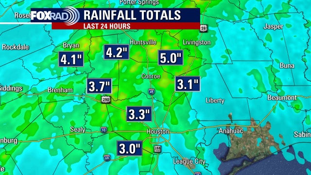
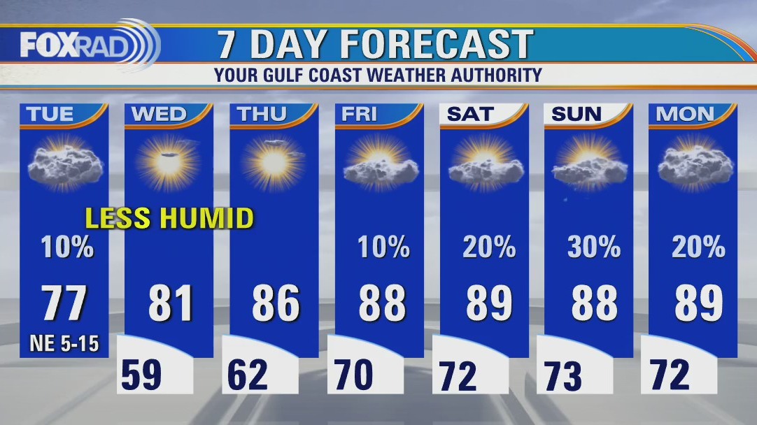
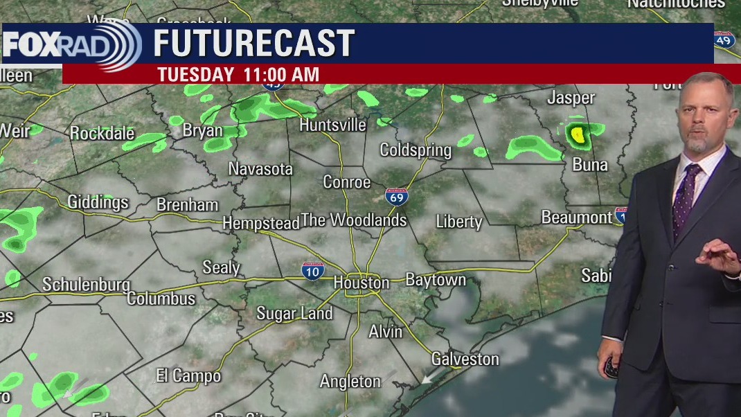
Following a solid 2-3" series of downpours on Monday, today we get to enjoy cooler air and slightly less humidity. Look for highs to remain in the mid to upper 70s this afternoon. We'll have two more pleasant mornings with lows in the 50s and 60s before hot and humid air surges back late this week.
Following a solid 2-3" series of downpours on Monday, today we get to enjoy cooler air and slightly less humidity. Look for highs to remain in the mid to upper 70s this afternoon. We'll have two more pleasant mornings with lows in the 50s and 60s before hot and humid air surges back late this week.

Tuesday morning weather forecast
A slow moving cold front will keep showers around southeast Texas Monday night into early Tuesday. Houston will enjoy a brief break from the humidity Tuesday afternoon and Wednesday. Warmer temperatures and muggy conditions return this weekend with rain chances cranking back up on Monday.
A slow moving cold front will keep showers around southeast Texas Monday night into early Tuesday. Houston will enjoy a brief break from the humidity Tuesday afternoon and Wednesday. Warmer temperatures and muggy conditions return this weekend with rain chances cranking back up on Monday.

Monday evening weather forecast
A slow moving cold front will keep showers around southeast Texas Monday night into early Tuesday. Houston will enjoy a brief break from the humidity Tuesday afternoon and Wednesday. Warmer temperatures and muggy conditions return this weekend with rain chances cranking back up on Monday.
A slow moving cold front will keep showers around southeast Texas Monday night into early Tuesday. Houston will enjoy a brief break from the humidity Tuesday afternoon and Wednesday. Warmer temperatures and muggy conditions return this weekend with rain chances cranking back up on Monday.


Keeping your furry friend safe and healthy as temperatures rise
If you're uncomfortable outside in the hot weather, your pet feels the same way.
If you're uncomfortable outside in the hot weather, your pet feels the same way.

Monday afternoon weather forecast
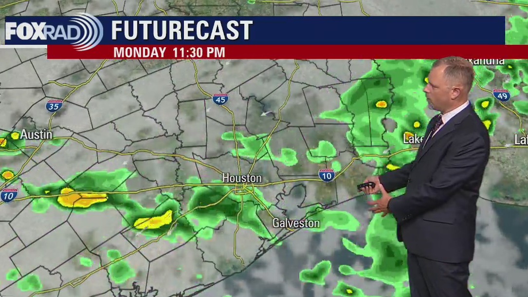
Finally some much needed rain is on the way, but the areas that need rain the most might miss out on the bulk of it. A cold front will move our way by this afternoon and, with abundant gulf moisture, should produce scattered heavy storms and even a couple of severe storms. Watch for storms north/northwest of Houston by late morning, then increasing for Harris and Montgomery County by mid to late this afternoon. Leftover could affect coastal areas by late day/evening. One bit of good news is that we should get a slight break from humidity from Tuesday through early Thursday.
Finally some much needed rain is on the way, but the areas that need rain the most might miss out on the bulk of it. A cold front will move our way by this afternoon and, with abundant gulf moisture, should produce scattered heavy storms and even a couple of severe storms. Watch for storms north/northwest of Houston by late morning, then increasing for Harris and Montgomery County by mid to late this afternoon. Leftover could affect coastal areas by late day/evening. One bit of good news is that we should get a slight break from humidity from Tuesday through early Thursday.

Sunday night leading into Monday morning weather forecast
A front moves through southeast Texas Monday afternoon bringing showers and storms. The rain should carry over into the overnight Monday and a few showers extend into Tuesday morning. Skies start to clear on Tuesday afternoon with a pleasant spring day in Houston on Wednesday.
A front moves through southeast Texas Monday afternoon bringing showers and storms. The rain should carry over into the overnight Monday and a few showers extend into Tuesday morning. Skies start to clear on Tuesday afternoon with a pleasant spring day in Houston on Wednesday.

Sunday Morning Forecast with Meteorologist Lena Maria
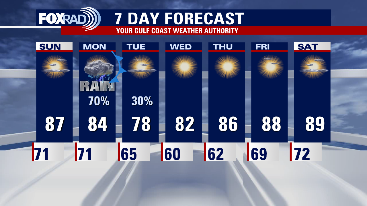
One more day with this warm, windy and humid pattern and then things will shift after a cold front brings us much needed beneficial rainfall tomorrow. Plan for scattered lighter showers to begin overnight and through midday Monday. The bulk of the rain arrives mid-afternoon through the evening hours, with heavier isolated downpours and thunderstorms. This will linger into the early hours of Tuesday, and then high pressure brings in with cooler temps and lower humidity for at least a few days. Warm again by the weekend.
One more day with this warm, windy and humid pattern and then things will shift after a cold front brings us much needed beneficial rainfall tomorrow. Plan for scattered lighter showers to begin overnight and through midday Monday. The bulk of the rain arrives mid-afternoon through the evening hours, with heavier isolated downpours and thunderstorms. This will linger into the early hours of Tuesday, and then high pressure brings in with cooler temps and lower humidity for at least a few days. Warm again by the weekend.

Saturday night leading into Sunday morning weather forecast
Another windy and warm day is on deck tomorrow. Temperatures will climb into the mid and upper 80s with partial sunshine. Our next cold front is set to slowly push in Monday afternoon - Monday night. Some of the rain could be heavy at times. A few leftover showers are still possible early Tuesday. High pressure builds for the remainder of next week, allowing for bright sunshine and dry weather to prevail.
Another windy and warm day is on deck tomorrow. Temperatures will climb into the mid and upper 80s with partial sunshine. Our next cold front is set to slowly push in Monday afternoon - Monday night. Some of the rain could be heavy at times. A few leftover showers are still possible early Tuesday. High pressure builds for the remainder of next week, allowing for bright sunshine and dry weather to prevail.
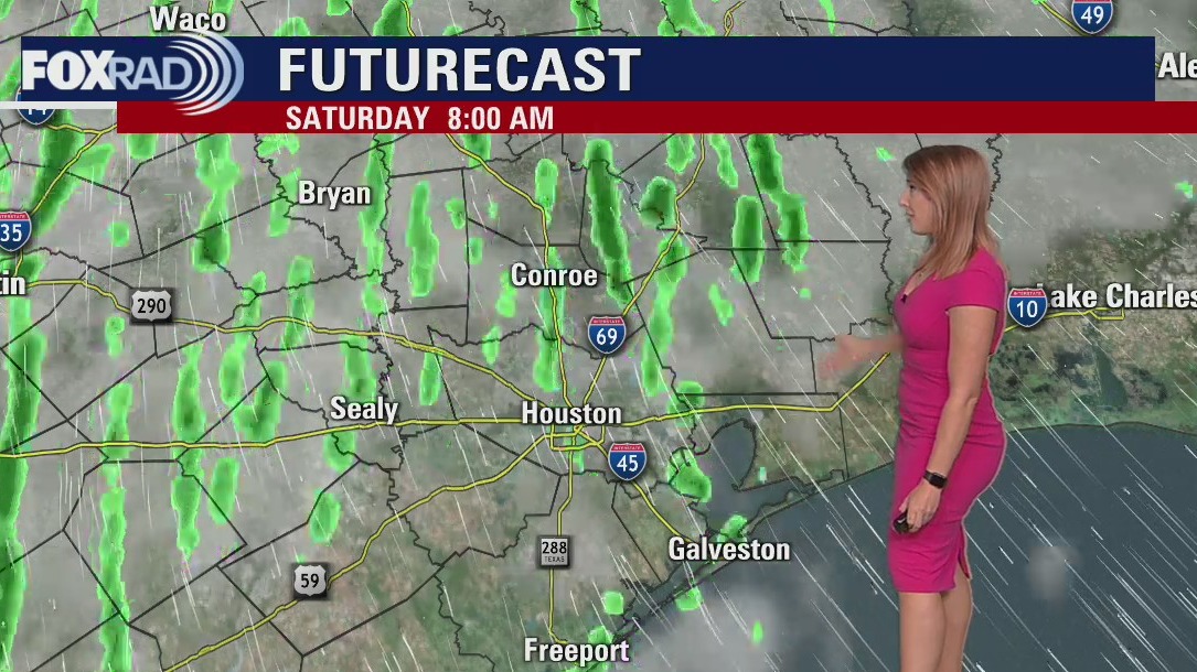

Saturday morning weather forecast
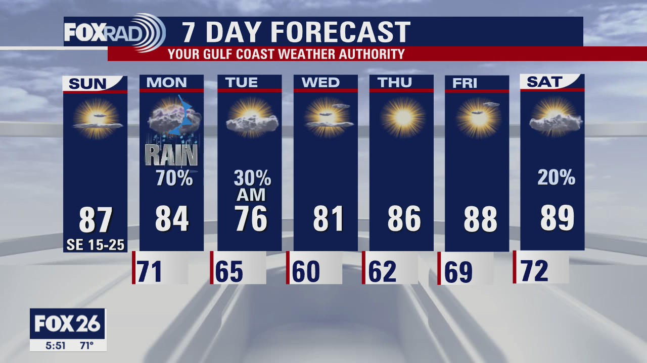
Windy and warm conditions stick around this weekend. Humidity will remain elevated with temps running above average both Saturday and Sunday with highs climbing into the mid and upper 80s. Our next cold front is set to arrive Monday, bringing rain and storms, some of which could be heavy.
Windy and warm conditions stick around this weekend. Humidity will remain elevated with temps running above average both Saturday and Sunday with highs climbing into the mid and upper 80s. Our next cold front is set to arrive Monday, bringing rain and storms, some of which could be heavy.

Friday evening weather forecast
Windy and warm conditions stick around this weekend. Humidity will remain elevated with temps running above average both Saturday and Sunday with highs climbing into the mid and upper 80s. Our next cold front is set to arrive Monday, bringing rain and storms, some of which could be heavy.
Windy and warm conditions stick around this weekend. Humidity will remain elevated with temps running above average both Saturday and Sunday with highs climbing into the mid and upper 80s. Our next cold front is set to arrive Monday, bringing rain and storms, some of which could be heavy.

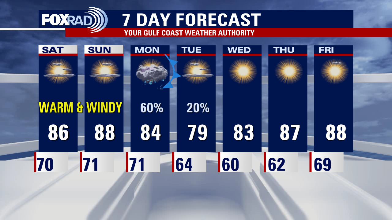
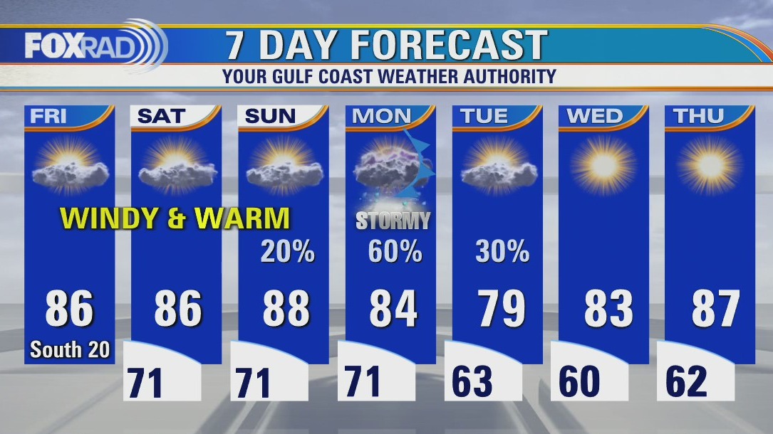
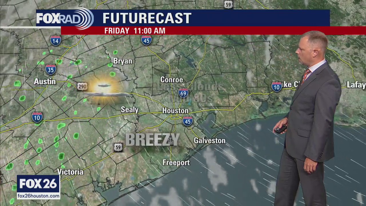
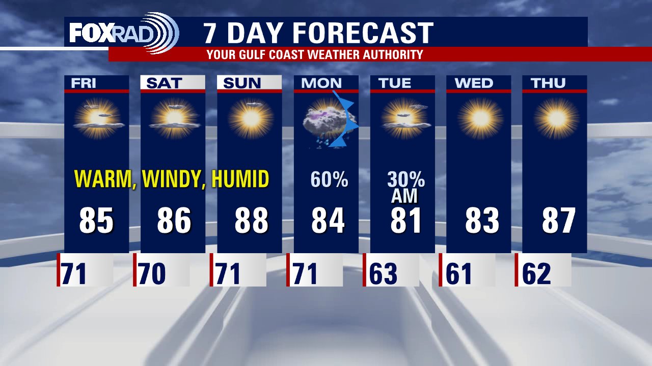
Friday afternoon weather forecast with Meteorologist Mike Iscovitz
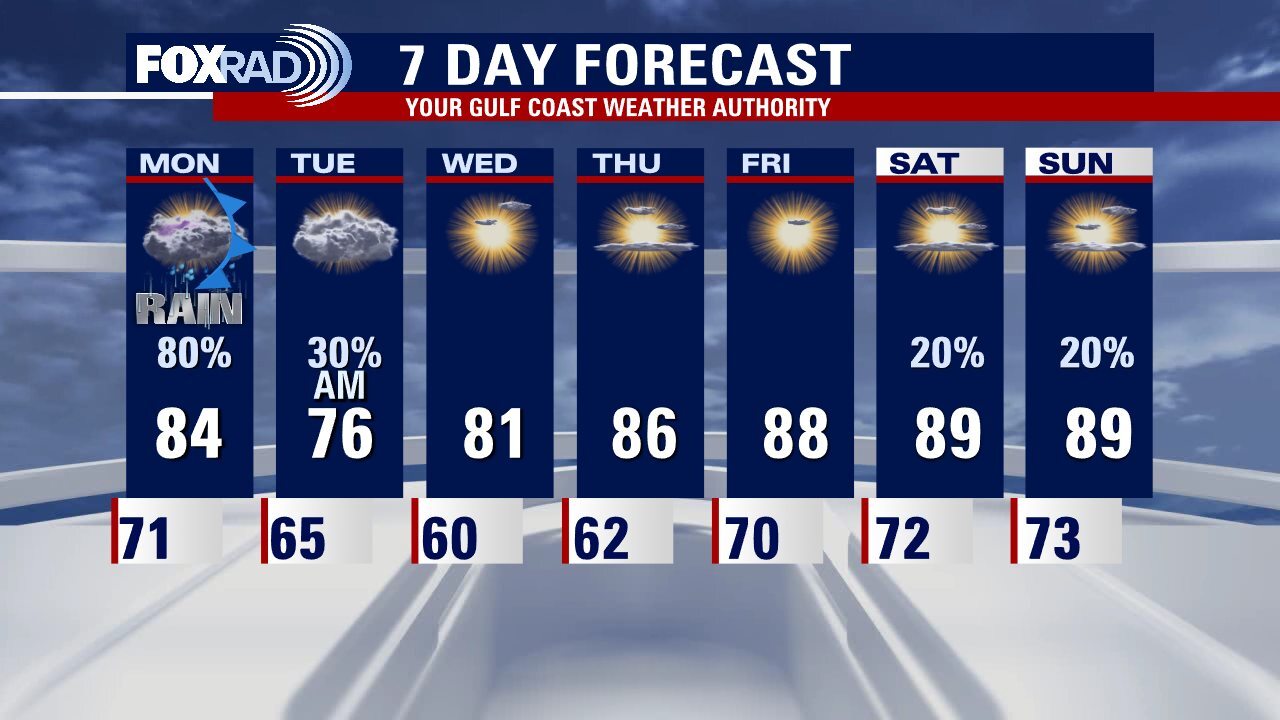
Our same breezy and warm weather pattern will remain in place for today through the weekend. Expect only isolated sprinkles with breezy southeast winds, lows near 70, and highs in the mid to upper 80s. A cold front arrives on Monday and there will be a chance for storms along with the potential for a few heavy downpours.
Our same breezy and warm weather pattern will remain in place for today through the weekend. Expect only isolated sprinkles with breezy southeast winds, lows near 70, and highs in the mid to upper 80s. A cold front arrives on Monday and there will be a chance for storms along with the potential for a few heavy downpours.

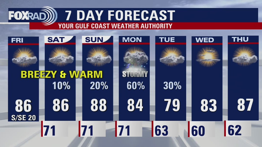
Friday afternoon weather forecast
Our same breezy and warm weather pattern will remain in place for today through the weekend. Expect only isolated sprinkles with breezy southeast winds, lows near 70 and highs in the mid to upper 80s. A cold front arrives on Monday and there will be a chance for storms along with potential for a few heavy downpours.
Our same breezy and warm weather pattern will remain in place for today through the weekend. Expect only isolated sprinkles with breezy southeast winds, lows near 70 and highs in the mid to upper 80s. A cold front arrives on Monday and there will be a chance for storms along with potential for a few heavy downpours.

Friday morning weather forecast
Houston is locked into a pattern of warm, windy, and humid weather until a cold front arrives on Monday. The front should push through Southeast Texas in the afternoon with the highest rain changes late in the day Monday. A few showers could still be around early Tuesday but starting Tuesday afternoon pleasant dry air makes a brief return.
Houston is locked into a pattern of warm, windy, and humid weather until a cold front arrives on Monday. The front should push through Southeast Texas in the afternoon with the highest rain changes late in the day Monday. A few showers could still be around early Tuesday but starting Tuesday afternoon pleasant dry air makes a brief return.

Thursday evening weather forecast with Meteorologist John Dawson
Houston is locked into a pattern of warm, windy, and humid weather until a cold front arrives on Monday. The front should push through Southeast Texas in the afternoon with the highest rain changes late in the day Monday. A few showers could still be around early Tuesday but starting Tuesday afternoon pleasant dry air makes a brief return.
Houston is locked into a pattern of warm, windy, and humid weather until a cold front arrives on Monday. The front should push through Southeast Texas in the afternoon with the highest rain changes late in the day Monday. A few showers could still be around early Tuesday but starting Tuesday afternoon pleasant dry air makes a brief return.
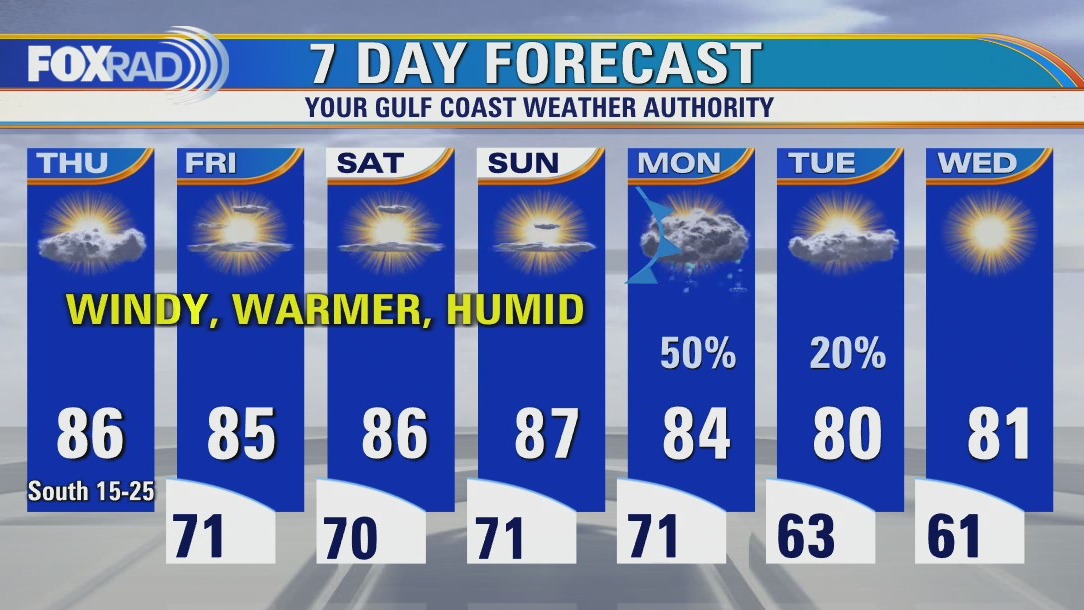

Thursday afternoon weather forecast
We are locked in to a warm, windy and humid pattern through the end of the week. Look for highs in the mid-upper 80s, lows around 70, gusty breezes out of the south and intervals of clouds and sun through Sunday. We'll be mainly dry until then as well, aside from a slight risk at an occasional passing spot shower or sprinkle. Next chance at meaningful rainfall is overnight Sunday into Monday, when a cold front looks to bring us showers and isolated storms that may linger into the day on Tuesday. Cooler, drier air to follow... for a few days, at least!
We are locked in to a warm, windy and humid pattern through the end of the week. Look for highs in the mid-upper 80s, lows around 70, gusty breezes out of the south and intervals of clouds and sun through Sunday. We'll be mainly dry until then as well, aside from a slight risk at an occasional passing spot shower or sprinkle. Next chance at meaningful rainfall is overnight Sunday into Monday, when a cold front looks to bring us showers and isolated storms that may linger into the day on Tuesday. Cooler, drier air to follow... for a few days, at least!