


Excessive heat on the way for Tuesday | FOX 26 Weather Forecast
Houston has had several days of triple digit afternoon highs and now there will be an EXCESSIVE HEAT WARNING for Tuesday. This is an upgrade from the Heat Advisory southeast Texas has been under for the past week. So use even more caution if you are working or playing outdoors.
Houston has had several days of triple digit afternoon highs and now there will be an EXCESSIVE HEAT WARNING for Tuesday. This is an upgrade from the Heat Advisory southeast Texas has been under for the past week. So use even more caution if you are working or playing outdoors.


Houston weather: Heat advisory in effect on Monday
A heat advisory is in effect until 10pm. FOX 26 Houston meteorologist Mike Iscovitz talks about the very hot weather and when you can expect to see a break from the triple digits.
A heat advisory is in effect until 10pm. FOX 26 Houston meteorologist Mike Iscovitz talks about the very hot weather and when you can expect to see a break from the triple digits.

FOX 26 Houston Weather Forecast: Heat, heat, and more heat!
More triple digit days coming at you this week. Look for the Heat Advisories to continue as well with the feels like temps in the 110-112 to start the work week. Stay cool, drink plenty of water and take some breaks if you are working or play outdoors. Isolated rain is possible but overall coverage remains low.
More triple digit days coming at you this week. Look for the Heat Advisories to continue as well with the feels like temps in the 110-112 to start the work week. Stay cool, drink plenty of water and take some breaks if you are working or play outdoors. Isolated rain is possible but overall coverage remains low.


FOX 26 Houston Weather Forecast
HEAT ADVISORIES remain in the forecast with afternoon highs forecast in the triple digits for the next several days. The feels like temps will continue to climb up to 110-112 so plan to stay safe outdoors. As the heat stays high, the rain chances stay low for this week.
HEAT ADVISORIES remain in the forecast with afternoon highs forecast in the triple digits for the next several days. The feels like temps will continue to climb up to 110-112 so plan to stay safe outdoors. As the heat stays high, the rain chances stay low for this week.

FOX 26 Houston Weather Forecast
Another Heat Advisory is in effect for SE Texas. Feels like temperatures could reach up to 112 degrees. Take it easy out there, drink lots of water and take breaks inside the shade. This heat continues next week with mostly dry conditions. Hurricane Ernesto passed by Bermuda this morning and will stay out to sea before it dissipates next week. All else is quiet in the tropics for now! The peak of the hurricane season is next month and we will likely see tropical activity increase soon. Stay up to date with the latest in the tropics by downloading the FOX Local app.
Another Heat Advisory is in effect for SE Texas. Feels like temperatures could reach up to 112 degrees. Take it easy out there, drink lots of water and take breaks inside the shade. This heat continues next week with mostly dry conditions. Hurricane Ernesto passed by Bermuda this morning and will stay out to sea before it dissipates next week. All else is quiet in the tropics for now! The peak of the hurricane season is next month and we will likely see tropical activity increase soon. Stay up to date with the latest in the tropics by downloading the FOX Local app.


FOX 26 Weather Forecast: Another heat advisory for Saturday
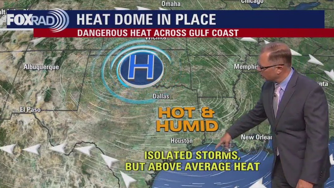
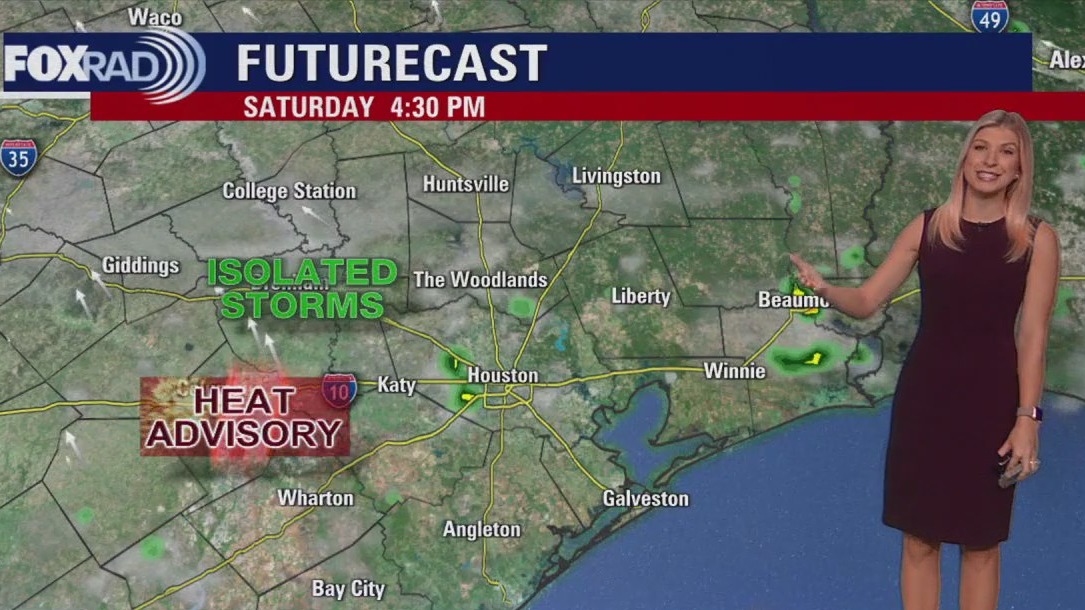
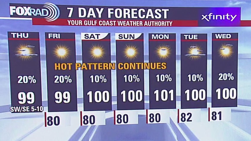
We hit 99? in many locations again today and yes, more high heat and humidity are on the way this weekend. A heat advisory has been extended area wide through at least Saturday evening. Highs this weekend will get close to 100? inland and in the mid 90s along the coast. Don?t be surprised to see a few afternoon storms, but they should be relatively small and short-lived. Beyond this weekend, we?ll stay hot next week, but there may be a slight pattern change to being slightly more cloud cover, a few more showers and highs ?only? in the mid 90s by mid to late next week.
We hit 99? in many locations again today and yes, more high heat and humidity are on the way this weekend. A heat advisory has been extended area wide through at least Saturday evening. Highs this weekend will get close to 100? inland and in the mid 90s along the coast. Don?t be surprised to see a few afternoon storms, but they should be relatively small and short-lived. Beyond this weekend, we?ll stay hot next week, but there may be a slight pattern change to being slightly more cloud cover, a few more showers and highs ?only? in the mid 90s by mid to late next week.

FOX 26 Houston Weather Forecast: Heat continues into the weekend
We hit 99? in many locations again today and yes, more high heat and humidity are on the way this weekend. A heat advisory has been extended area wide through at least Saturday evening. Highs this weekend will get close to 100? inland and in the mid 90s along the coast. Don?t be surprised to see a few afternoon storms, but they should be relatively small and short-lived. Beyond this weekend, we?ll stay hot next week, but there may be a slight pattern change to being slightly more cloud cover, a few more showers and highs ?only? in the mid 90s by mid to late next week.
We hit 99? in many locations again today and yes, more high heat and humidity are on the way this weekend. A heat advisory has been extended area wide through at least Saturday evening. Highs this weekend will get close to 100? inland and in the mid 90s along the coast. Don?t be surprised to see a few afternoon storms, but they should be relatively small and short-lived. Beyond this weekend, we?ll stay hot next week, but there may be a slight pattern change to being slightly more cloud cover, a few more showers and highs ?only? in the mid 90s by mid to late next week.


FOX 26 Houston Weather Forecast
Another hot day in Southeast Texas. There is a Heat Advisory in effect until 8pm with feels like temperatures soaring to 110 degrees. Stay hydrated and do your outdoor activities early in the morning or late in the day. Isolated showers are possible today, but overall coverage remains low. Beginning on Saturday, afternoon highs will be in the triple digits and that trend continues into early next week. Hurricane Ernesto is heading toward Bermuda and then will continue to move north in the Atlantic. Stay up-to-date on the weather where you live by downloading the FOX Local app.
Another hot day in Southeast Texas. There is a Heat Advisory in effect until 8pm with feels like temperatures soaring to 110 degrees. Stay hydrated and do your outdoor activities early in the morning or late in the day. Isolated showers are possible today, but overall coverage remains low. Beginning on Saturday, afternoon highs will be in the triple digits and that trend continues into early next week. Hurricane Ernesto is heading toward Bermuda and then will continue to move north in the Atlantic. Stay up-to-date on the weather where you live by downloading the FOX Local app.


FOX 26 Houston Weather Forecast: Heat, heat, and more heat!
Temperatures are rising & it's getting hot, hot hot! Heat Advisory sticks around for one more day until 8 pm Friday evening with "Feels Like" temps near 105-110. Drink plenty of water and don't forget the sunscreen if you plan to be outside. A few showers and storms will continue through early evening with only a slim shot for rain the next several afternoons. Get ready for a stretch of triple digit days this weekend through the middle of next week. This will likely be the hottest stretch so far this summer season! I don't expect anything bothering us from the tropics for now. But hurricane warnings are out for Bermuda with Hurricane Ernesto headed that way late Friday and Saturday. Track weather where you live with our FOX 26 weather app & our smart TV app, Fox Local.
Temperatures are rising & it's getting hot, hot hot! Heat Advisory sticks around for one more day until 8 pm Friday evening with "Feels Like" temps near 105-110. Drink plenty of water and don't forget the sunscreen if you plan to be outside. A few showers and storms will continue through early evening with only a slim shot for rain the next several afternoons. Get ready for a stretch of triple digit days this weekend through the middle of next week. This will likely be the hottest stretch so far this summer season! I don't expect anything bothering us from the tropics for now. But hurricane warnings are out for Bermuda with Hurricane Ernesto headed that way late Friday and Saturday. Track weather where you live with our FOX 26 weather app & our smart TV app, Fox Local.


FOX 26 Houston Weather Forecast
Temperatures are rising & it's getting hot, hot hot! Heat Advisory sticks around for one more day until 8 pm Friday evening with "Feels Like" temps near 105-110. Drink plenty of water and don't forget the sunscreen if you plan to be outside. A few showers and storms will continue through early evening with only a slim shot for rain the next several afternoons. Get ready for a stretch of triple digit days this weekend through the middle of next week. This will likely be the hottest stretch so far this summer season! I don't expect anything bothering us from the tropics for now. But hurricane warnings are out for Bermuda with Hurricane Ernesto headed that way late Friday and Saturday. Track weather where you live with our FOX 26 weather app & our smart TV app, FOX Local.
Temperatures are rising & it's getting hot, hot hot! Heat Advisory sticks around for one more day until 8 pm Friday evening with "Feels Like" temps near 105-110. Drink plenty of water and don't forget the sunscreen if you plan to be outside. A few showers and storms will continue through early evening with only a slim shot for rain the next several afternoons. Get ready for a stretch of triple digit days this weekend through the middle of next week. This will likely be the hottest stretch so far this summer season! I don't expect anything bothering us from the tropics for now. But hurricane warnings are out for Bermuda with Hurricane Ernesto headed that way late Friday and Saturday. Track weather where you live with our FOX 26 weather app & our smart TV app, FOX Local.

Heat advisory in effect | Fox 26 Houston Weather Forecast
Surprise...it's going to be really hot again. This won't come as a shock since it is August after all, but we are under a heat advisory once again until 8pm. watch for a few pop-up storms this afternoon and tomorrow afternoon, but they will be isolated and won't help with temperatures very much. In the extended forecast, don't expect many changes as high pressure builds overhead and allows us to heat to near 100 each day through the weekend. In the tropics, Hurricane Ernesto will get larger and stronger today as it heads toward Bermuda. They could take a direct hit late tomorrow and Ernesto could be a major hurricane by then. There won't be a direct impact on the US, but large waves will eventually cause some dangerous surf. The eastern provinces of Canada like Nova Scotia and Newfoundland will get a very quick brush with Ernesto this weekend.
Surprise...it's going to be really hot again. This won't come as a shock since it is August after all, but we are under a heat advisory once again until 8pm. watch for a few pop-up storms this afternoon and tomorrow afternoon, but they will be isolated and won't help with temperatures very much. In the extended forecast, don't expect many changes as high pressure builds overhead and allows us to heat to near 100 each day through the weekend. In the tropics, Hurricane Ernesto will get larger and stronger today as it heads toward Bermuda. They could take a direct hit late tomorrow and Ernesto could be a major hurricane by then. There won't be a direct impact on the US, but large waves will eventually cause some dangerous surf. The eastern provinces of Canada like Nova Scotia and Newfoundland will get a very quick brush with Ernesto this weekend.
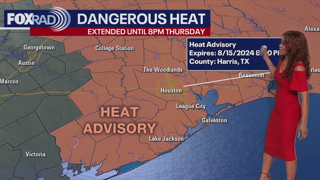

FOX 26 Houston Weather Forecast: Heat continues for Thursday
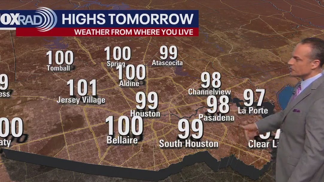
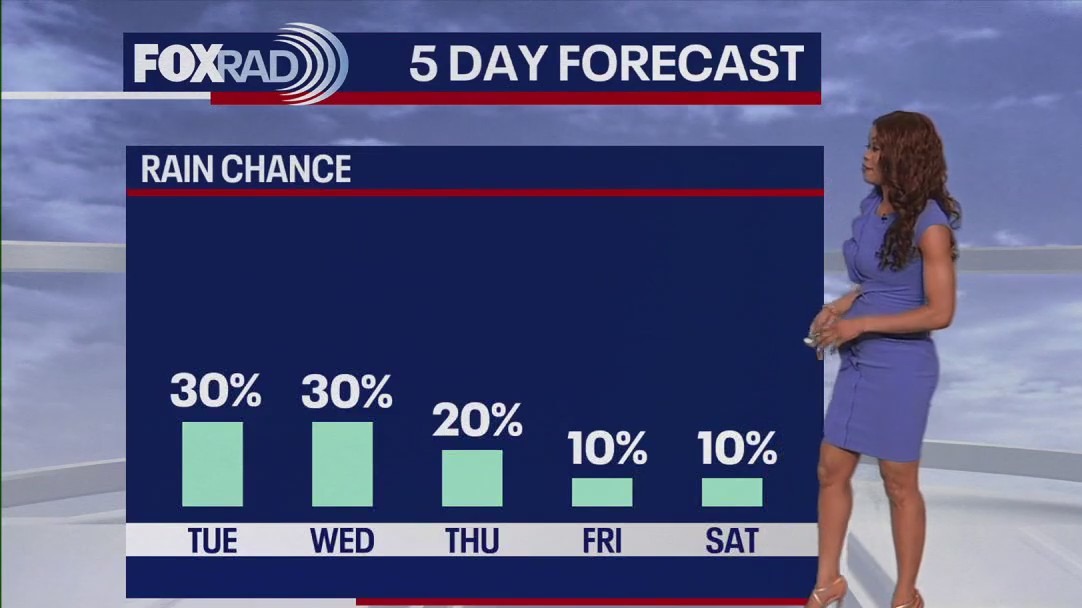
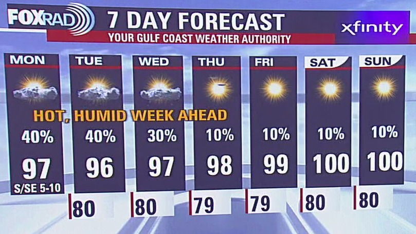
Heat Advisory has been extended once again for Houston and surrounding areas until 8 pm Thursday. Heat index values will still soar to around 110 for Thursday afternoon and most likely stay there through the weekend. Actual temperatures remain near triple digits for the next several days. Rain will be limited with isolated showers and storms possible the next few days. Rain chances drop to only 10% this weekend. So be careful in the heat with not much relief expected anytime soon. Gulf of Mexico is quiet. But Ernesto is now a category 1 hurricane in the western Atlantic. As it pulls away from Puerto Rico, it will strengthen & get dangerously close to Bermuda late Friday & Saturday bringing the threat for strong winds and flooding. Outside of Ernesto, the rest of the Atlantic basin is quiet for now.
Heat Advisory has been extended once again for Houston and surrounding areas until 8 pm Thursday. Heat index values will still soar to around 110 for Thursday afternoon and most likely stay there through the weekend. Actual temperatures remain near triple digits for the next several days. Rain will be limited with isolated showers and storms possible the next few days. Rain chances drop to only 10% this weekend. So be careful in the heat with not much relief expected anytime soon. Gulf of Mexico is quiet. But Ernesto is now a category 1 hurricane in the western Atlantic. As it pulls away from Puerto Rico, it will strengthen & get dangerously close to Bermuda late Friday & Saturday bringing the threat for strong winds and flooding. Outside of Ernesto, the rest of the Atlantic basin is quiet for now.


FOX 26 Houston Weather Forecast
Heat Advisory has been extended once again for Houston and surrounding areas until 8 p.m. Thursday. Heat index values will still soar to around 110 for Thursday afternoon and most likely stay there through the weekend. Actual temperatures remain near triple digits for the next several days. Rain will be limited with isolated showers and storms possible the next few days. Rain chances drop to only 10% this weekend. So be careful in the heat with not much relief expected anytime soon. Gulf of Mexico is quiet. But Ernesto is now a category 1 hurricane in the western Atlantic. As it pulls away from Puerto Rico, it will strengthen & get dangerously close to Bermuda late Friday & Saturday bringing the threat for strong winds and flooding. Outside of Ernesto, the rest of the Atlantic basin is quiet for now.
Heat Advisory has been extended once again for Houston and surrounding areas until 8 p.m. Thursday. Heat index values will still soar to around 110 for Thursday afternoon and most likely stay there through the weekend. Actual temperatures remain near triple digits for the next several days. Rain will be limited with isolated showers and storms possible the next few days. Rain chances drop to only 10% this weekend. So be careful in the heat with not much relief expected anytime soon. Gulf of Mexico is quiet. But Ernesto is now a category 1 hurricane in the western Atlantic. As it pulls away from Puerto Rico, it will strengthen & get dangerously close to Bermuda late Friday & Saturday bringing the threat for strong winds and flooding. Outside of Ernesto, the rest of the Atlantic basin is quiet for now.


Fox 26 Houston Weather Forecast
Again, welcome back to school for even more kids across the area - it's going to be another very hot one with a heat advisory in effect until 8pm today. Highs should hit the upper 90s with a heat index topping out between 104 and 109. Highs all across our region will head into the upper 90s and low 100s and that pattern will remain in place for at least a week. Ernesto will get stronger today and tomorrow as it moves away from Puerto Rico and toward Bermuda. It could hit major hurricane strength late this week and a cat 3 or 4 is not out of the question. Elsewhere, we have a lot of Saharan dust in the Atlantic which is suppressing activity for now.
Again, welcome back to school for even more kids across the area - it's going to be another very hot one with a heat advisory in effect until 8pm today. Highs should hit the upper 90s with a heat index topping out between 104 and 109. Highs all across our region will head into the upper 90s and low 100s and that pattern will remain in place for at least a week. Ernesto will get stronger today and tomorrow as it moves away from Puerto Rico and toward Bermuda. It could hit major hurricane strength late this week and a cat 3 or 4 is not out of the question. Elsewhere, we have a lot of Saharan dust in the Atlantic which is suppressing activity for now.


FOX 26 Houston Weather Forecast: More heat for Wednesday
Heat Advisory has been extended until 8pm Wednesday for Houston and surrounding areas. Heat index values near 110 are likely once again Wednesday PM with more heat alerts likely coming later this week. A few showers and storms have popped up near Katy & Houston that may provide some brief heat relief. But showers should start to fade after 7pm. Rain chances remain at 30% Wednesday but get even lower the rest of the week. Temperatures should reach triple digits by Saturday so plan on a very hot August pattern. Tropical Storm Ernesto should brush by Puerto Rico tonight and become a hurricane tomorrow. Bermuda could get a direct hit by Saturday as Ernesto is projected to strengthen to a Category 2 hurricane. Get the latest weather where you live and all of the tropical forecasts by downloading our FOX 26 weather app and our smart TV app, FOX Local.
Heat Advisory has been extended until 8pm Wednesday for Houston and surrounding areas. Heat index values near 110 are likely once again Wednesday PM with more heat alerts likely coming later this week. A few showers and storms have popped up near Katy & Houston that may provide some brief heat relief. But showers should start to fade after 7pm. Rain chances remain at 30% Wednesday but get even lower the rest of the week. Temperatures should reach triple digits by Saturday so plan on a very hot August pattern. Tropical Storm Ernesto should brush by Puerto Rico tonight and become a hurricane tomorrow. Bermuda could get a direct hit by Saturday as Ernesto is projected to strengthen to a Category 2 hurricane. Get the latest weather where you live and all of the tropical forecasts by downloading our FOX 26 weather app and our smart TV app, FOX Local.


FOX 26 Houston Weather Forecast
Heat Advisory has been extended until 8pm Wednesday for Houston and surrounding areas. Heat index values near 110 are likely once again Wednesday PM with more heat alerts likely coming later this week. A few showers and storms have popped up near Katy & Houston that may provide some brief heat relief. But showers should start to fade after 7pm. Rain chances remain at 30% Wednesday but get even lower the rest of the week. Temperatures should reach triple digits by Saturday so plan on a very hot August pattern. Tropical Storm Ernesto should brush by Puerto Rico tonight and become a hurricane tomorrow. Bermuda could get a direct hit by Saturday as Ernesto is projected to strengthen to a Category 2 hurricane. Get the latest weather where you live and all of the tropical forecasts by downloading our FOX 26 weather app and our smart TV app FOX Local.
Heat Advisory has been extended until 8pm Wednesday for Houston and surrounding areas. Heat index values near 110 are likely once again Wednesday PM with more heat alerts likely coming later this week. A few showers and storms have popped up near Katy & Houston that may provide some brief heat relief. But showers should start to fade after 7pm. Rain chances remain at 30% Wednesday but get even lower the rest of the week. Temperatures should reach triple digits by Saturday so plan on a very hot August pattern. Tropical Storm Ernesto should brush by Puerto Rico tonight and become a hurricane tomorrow. Bermuda could get a direct hit by Saturday as Ernesto is projected to strengthen to a Category 2 hurricane. Get the latest weather where you live and all of the tropical forecasts by downloading our FOX 26 weather app and our smart TV app FOX Local.


Fox 26 Houston Weather Forecast
Welcome back to school for thousands more kids today - it's going to be another very muggy day with a heat advisory in effect, but with scattered afternoon storms expected. For the rest of the week it should get progressively hotter with only isolated rain. Highs will reach the upper 90s and possibly some low 100s for the next couple of weeks. In the tropics, Tropical Storm Ernesto is pounding the northeast Caribbean and is headed toward Puerto Rico before curving into the Atlantic. It could become a major hurricane as it moves toward Bermuda. It's not likely to be a threat to the US.
Welcome back to school for thousands more kids today - it's going to be another very muggy day with a heat advisory in effect, but with scattered afternoon storms expected. For the rest of the week it should get progressively hotter with only isolated rain. Highs will reach the upper 90s and possibly some low 100s for the next couple of weeks. In the tropics, Tropical Storm Ernesto is pounding the northeast Caribbean and is headed toward Puerto Rico before curving into the Atlantic. It could become a major hurricane as it moves toward Bermuda. It's not likely to be a threat to the US.

FOX 26 Houston Weather Forecast: Heat, heat, and more heat!
Heat Advisory has been extended until 7pm Tuesday evening and will include the entire area Tuesday. Look for heat index values up to 112 which makes it difficult to be outside for long periods of time. Try to stay in the shade and drink lots of water if you must be outside. Make sure kids are being extra careful in the heat for after school practices. More heat advisories will likely be needed later this week. Temperatures stay near 100 and there will only be a few downpours to cool us off. Tropical Storm Ernesto has formed in the western Atlantic with 40 mph winds. Ernesto is forecast to become a hurricane by Thursday. It should turn north and away from the United States but will be a threat for Puerto Rico and Bermuda.
Heat Advisory has been extended until 7pm Tuesday evening and will include the entire area Tuesday. Look for heat index values up to 112 which makes it difficult to be outside for long periods of time. Try to stay in the shade and drink lots of water if you must be outside. Make sure kids are being extra careful in the heat for after school practices. More heat advisories will likely be needed later this week. Temperatures stay near 100 and there will only be a few downpours to cool us off. Tropical Storm Ernesto has formed in the western Atlantic with 40 mph winds. Ernesto is forecast to become a hurricane by Thursday. It should turn north and away from the United States but will be a threat for Puerto Rico and Bermuda.


FOX 26 Houston Weather Forecast: The heat is here to stay this week
Heat Advisory has been extended until 7pm Tuesday evening and will include the entire area Tuesday. Look for heat index values up to 112 which makes it difficult to be outside for long periods of time. Try to stay in the shade and drink lots of water if you must be outside. Make sure kids are being extra careful in the heat for after school practices. More heat advisories will likely be needed later this week. Temperatures stay near 100 and there will only be a few downpours to cool us off. Tropical Storm Ernesto has formed in the western Atlantic with 40 mph winds. Ernesto is forecast to become a hurricane by Thursday. It should turn north and away from the United States but will be a threat for Puerto Rico and Bermuda.
Heat Advisory has been extended until 7pm Tuesday evening and will include the entire area Tuesday. Look for heat index values up to 112 which makes it difficult to be outside for long periods of time. Try to stay in the shade and drink lots of water if you must be outside. Make sure kids are being extra careful in the heat for after school practices. More heat advisories will likely be needed later this week. Temperatures stay near 100 and there will only be a few downpours to cool us off. Tropical Storm Ernesto has formed in the western Atlantic with 40 mph winds. Ernesto is forecast to become a hurricane by Thursday. It should turn north and away from the United States but will be a threat for Puerto Rico and Bermuda.

Fox 26 Houston Weather Forecast
Welcome back to school for tens of thousands of students across our area this week - it is going to be a hot one with high temperatures ranging from about 95-99 and morning bus stop temperatures near 80. Today, Tuesday and Wednesday will bring a chance for scattered storms for the late afternoon and early evening, so keep that in mind for after school practices. In the tropics, we are getting into the historically busy time of the year and we will be watching a developing system (likely Ernesto) this week that may become an intense hurricane late in the week. The system is not likely to have a direct impact on the United States and will stay far away from the Gulf of Mexico.
Welcome back to school for tens of thousands of students across our area this week - it is going to be a hot one with high temperatures ranging from about 95-99 and morning bus stop temperatures near 80. Today, Tuesday and Wednesday will bring a chance for scattered storms for the late afternoon and early evening, so keep that in mind for after school practices. In the tropics, we are getting into the historically busy time of the year and we will be watching a developing system (likely Ernesto) this week that may become an intense hurricane late in the week. The system is not likely to have a direct impact on the United States and will stay far away from the Gulf of Mexico.