

Tropical Storm Beta approaches Texas coast
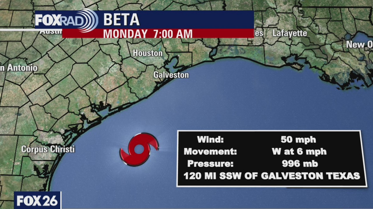
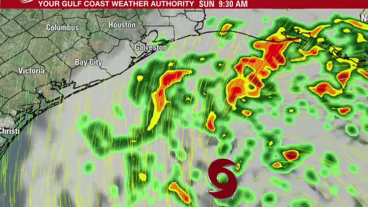
Tropical Storm Beta has winds at 50 mph and it is moving west-northwest at 7 mph. Rain is still heavy along the coast where a 3-5 foot storm surge has flooded some areas. The forecast keeps the storm near the coast after making landfall later today. The on-and-off rain bands will continue into Wednesday.
Tropical Storm Beta has winds at 50 mph and it is moving west-northwest at 7 mph. Rain is still heavy along the coast where a 3-5 foot storm surge has flooded some areas. The forecast keeps the storm near the coast after making landfall later today. The on-and-off rain bands will continue into Wednesday.
Tropical Storm Beta approaches Texas coast
Tropical Storm Beta is continuing to move toward the central Texas coast. Watches and warning have been issued in the Houston area ahead of the tropical storm.
Tropical Storm Beta is continuing to move toward the central Texas coast. Watches and warning have been issued in the Houston area ahead of the tropical storm.
Monday morning forecast/tropics update
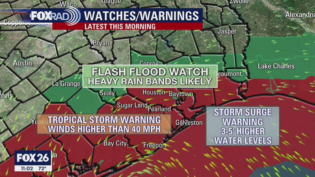
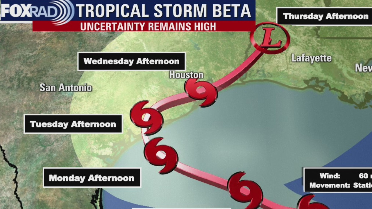
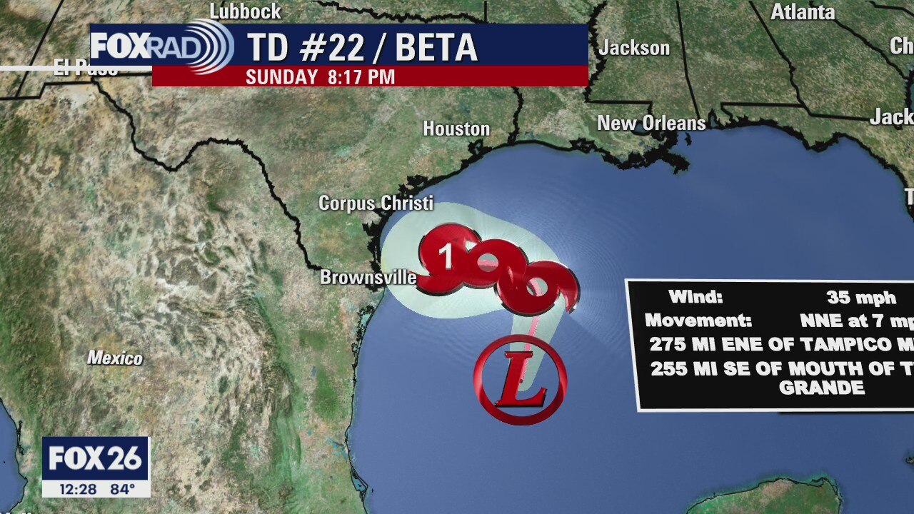
All eyes are still on the Gulf with Tropical Storm Beta. This storm is struggling but still a concern for Houston. Landfall will happen near Matagorda Bay tomorrow afternoon. The forecast track takes the storm slowly over the Houston area Tuesday. So rain chances remain high and a Flash Flood Watch is in place until Tuesday evening for most of the Houston area. Harris County along with all the coastal counties are under a Tropical Storm Warning.
All eyes are still on the Gulf with Tropical Storm Beta. This storm is struggling but still a concern for Houston. Landfall will happen near Matagorda Bay tomorrow afternoon. The forecast track takes the storm slowly over the Houston area Tuesday. So rain chances remain high and a Flash Flood Watch is in place until Tuesday evening for most of the Houston area. Harris County along with all the coastal counties are under a Tropical Storm Warning.
Sunday evening weather forecast/tropics update
All eyes are still on the Gulf with Tropical Storm Beta. This storm is struggling but still a concern for Houston. Landfall will happen near Matagorda Bay tomorrow afternoon. The forecast track takes the storm slowly over the Houston area Tuesday. So rain chances remain high and a Flash Flood Watch is in place until Tuesday evening for most of the Houston area. Harris County along with all the coastal counties are under a Tropical Storm Warning.
All eyes are still on the Gulf with Tropical Storm Beta. This storm is struggling but still a concern for Houston. Landfall will happen near Matagorda Bay tomorrow afternoon. The forecast track takes the storm slowly over the Houston area Tuesday. So rain chances remain high and a Flash Flood Watch is in place until Tuesday evening for most of the Houston area. Harris County along with all the coastal counties are under a Tropical Storm Warning.
Houston-area weather forecast 9/20
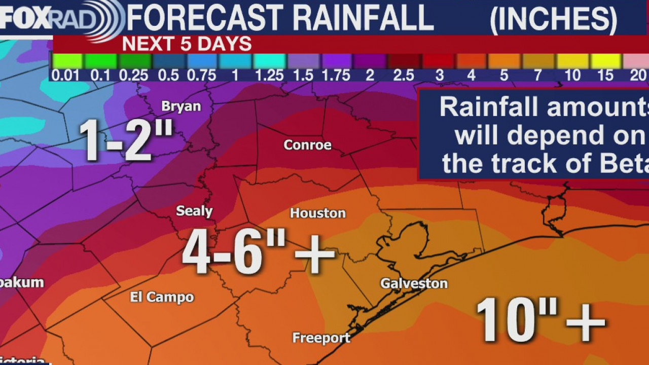
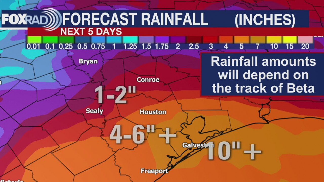
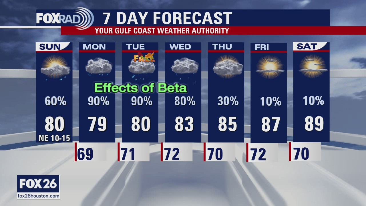
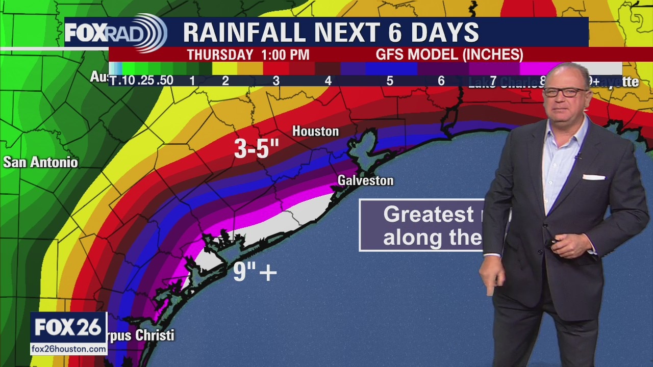
The effects of tropical storm Beta are already being felt along the Texas coastline and the outer rain bands will begin moving into the Houston-area later this afternoon. Expect the heaviest rain to hold off until Monday and Tuesday. A widespread 10"+ rainfall along our coast is expected before Beta moves out on Wednesday, with isolated higher amounts likely. Farther inland, totals will range between 4" and 6" with some spots picking up more than that. Totals will drop off rather significantly once you get north of Liberty, Harris, Fort Bend, and Wharton counties. A Flash Flood Watch is in effect until Tuesday for most of the area as well as a Tropical Storm Warning for our coastal counties including Harris, Fort Bend, and Wharton counties.
The effects of tropical storm Beta are already being felt along the Texas coastline and the outer rain bands will begin moving into the Houston-area later this afternoon. Expect the heaviest rain to hold off until Monday and Tuesday. A widespread 10"+ rainfall along our coast is expected before Beta moves out on Wednesday, with isolated higher amounts likely. Farther inland, totals will range between 4" and 6" with some spots picking up more than that. Totals will drop off rather significantly once you get north of Liberty, Harris, Fort Bend, and Wharton counties. A Flash Flood Watch is in effect until Tuesday for most of the area as well as a Tropical Storm Warning for our coastal counties including Harris, Fort Bend, and Wharton counties.
Sunday morning weather forecast/tropics update
FOX 26's John Dawson has the latest on Tropical Storm Beta and the local Houston area forecast.
FOX 26's John Dawson has the latest on Tropical Storm Beta and the local Houston area forecast.
Saturday evening forecast/tropics update
FOX 26's John Dawson has the very latest forecast on TS Beta and its potential impacts on the Houston area.
FOX 26's John Dawson has the very latest forecast on TS Beta and its potential impacts on the Houston area.
Houston-area weather forecast 9/19
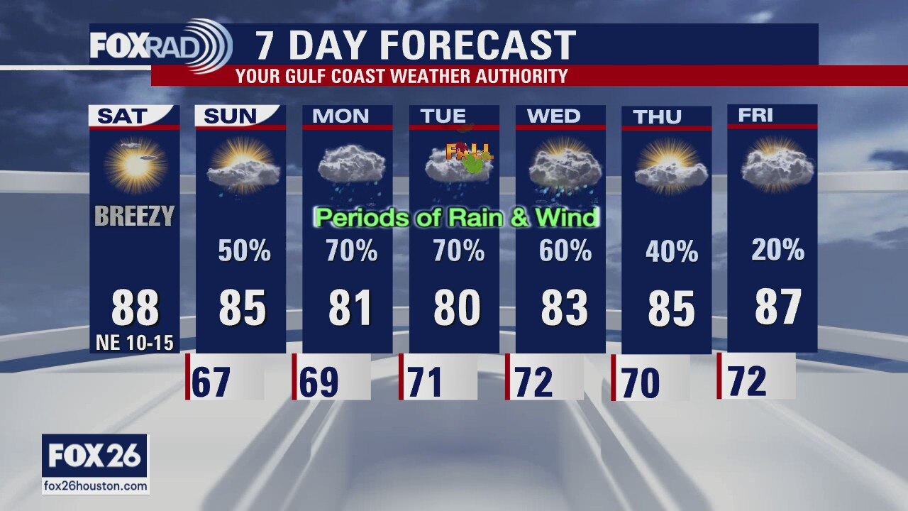
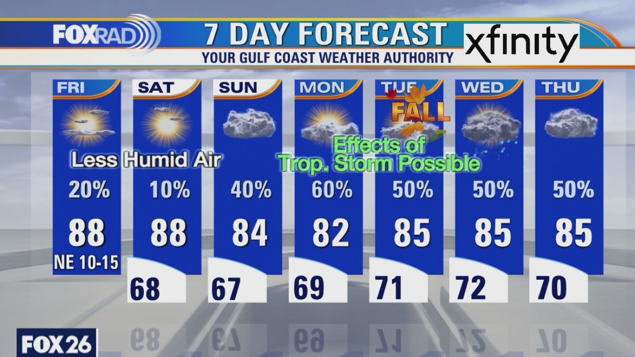
Saturday is going to be a spectacular day with mostly sunny skies and highs reaching the upper 80s, but don't get used to the nice forecast. Things will begin changing as we deal with some of the initial impacts of Tropical Storm Beta, beginning on Sunday. This will mainly be a coastal event so conditions should dramatically improve the farther inland you live. Look for waves of rain and wind to begin on Sunday and increasing as we head through at least Wednesday. Beta will initially slow as it makes a close encounter with the Texas coast and possibly move northeast and hug that coastline causing major beach erosion and coastal flooding Tuesday into Wednesday. This is a forecast to stay up to date on, so check back throughout the weekend.
Saturday is going to be a spectacular day with mostly sunny skies and highs reaching the upper 80s, but don't get used to the nice forecast. Things will begin changing as we deal with some of the initial impacts of Tropical Storm Beta, beginning on Sunday. This will mainly be a coastal event so conditions should dramatically improve the farther inland you live. Look for waves of rain and wind to begin on Sunday and increasing as we head through at least Wednesday. Beta will initially slow as it makes a close encounter with the Texas coast and possibly move northeast and hug that coastline causing major beach erosion and coastal flooding Tuesday into Wednesday. This is a forecast to stay up to date on, so check back throughout the weekend.

Saturday morning weather forecast
Besides coastal flooding, rainfall is the other big concern with TS Beta next week. Right now it looks like the problem areas would be right along the coast where they could get 8-10 inches of rainfall. We all need to stay alert next week.
Besides coastal flooding, rainfall is the other big concern with TS Beta next week. Right now it looks like the problem areas would be right along the coast where they could get 8-10 inches of rainfall. We all need to stay alert next week.
Keeping an eye on Beta...
As expected Tropical Storm Beta has formed in the Gulf with winds at 40mph. The forecast is still very much in question, but it looks to be a problem for a lot of the Texas coast early next week. Stay aware of the forecast over the weekend.
As expected Tropical Storm Beta has formed in the Gulf with winds at 40mph. The forecast is still very much in question, but it looks to be a problem for a lot of the Texas coast early next week. Stay aware of the forecast over the weekend.
Tropical storm expected to form in the Gulf
Our weather looks very nice over the next two days as we enjoy less humid air and a cooler Saturday and Sunday morning. Beyond that, we have to watch what will likely be Tropical Storm Beta moving slowly toward Texas. At this point, the forecast is highly uncertain both in location and size of this storm. Be prepared for rain beginning Sunday through the middle of next week, especially near the coast.
Our weather looks very nice over the next two days as we enjoy less humid air and a cooler Saturday and Sunday morning. Beyond that, we have to watch what will likely be Tropical Storm Beta moving slowly toward Texas. At this point, the forecast is highly uncertain both in location and size of this storm. Be prepared for rain beginning Sunday through the middle of next week, especially near the coast.
Friday weather forecast
Our weather looks very nice over the next two days as we enjoy less humid air and a cooler Saturday and Sunday morning. Beyond that, we have to watch what will likely be Tropical Storm Wilfred moving slowly toward Texas. At this point, the forecast is highly uncertain both in location and size of this storm. Be prepared for rain beginning Sunday through the middle of next week, especially near the coast.
Our weather looks very nice over the next two days as we enjoy less humid air and a cooler Saturday and Sunday morning. Beyond that, we have to watch what will likely be Tropical Storm Wilfred moving slowly toward Texas. At this point, the forecast is highly uncertain both in location and size of this storm. Be prepared for rain beginning Sunday through the middle of next week, especially near the coast.
Thursday evening weather forecast
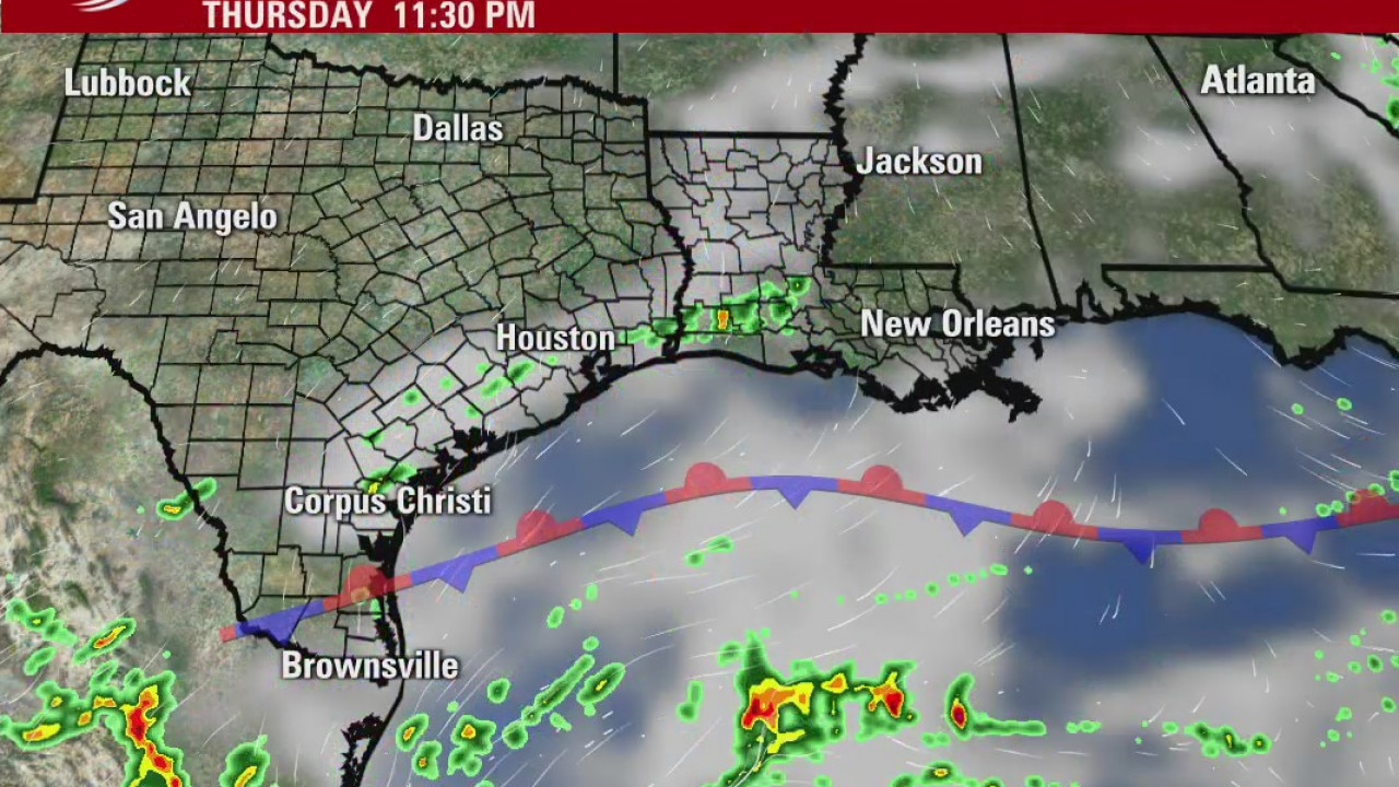
A weak front will push into the region over the next day or so and that will lead to clearing skies and somewhat cooler temperatures. We can expect lows dipping into the 60s over the weekend. The rain possibilities for the coming week will greatly depend on what happens with TD 22 in the southern Gulf of Mexico and at this point it is too early to tell.
A weak front will push into the region over the next day or so and that will lead to clearing skies and somewhat cooler temperatures. We can expect lows dipping into the 60s over the weekend. The rain possibilities for the coming week will greatly depend on what happens with TD 22 in the southern Gulf of Mexico and at this point it is too early to tell.
Thursday weather forecast
Tropical depression Sally will soak the Carolinas today after dropping more than 25? of rain in Florida. Our high yesterday reached 96, but today?s scattered showers and storms should hold our highs closer to 90. Look for a gradual arrival of drier air tomorrow and this weekend with lows in the 60s. A weak tropical low is likely to form well to our south, so we?ll watch that over the next several days.
Tropical depression Sally will soak the Carolinas today after dropping more than 25? of rain in Florida. Our high yesterday reached 96, but today?s scattered showers and storms should hold our highs closer to 90. Look for a gradual arrival of drier air tomorrow and this weekend with lows in the 60s. A weak tropical low is likely to form well to our south, so we?ll watch that over the next several days.
Thursday morning weather forecast
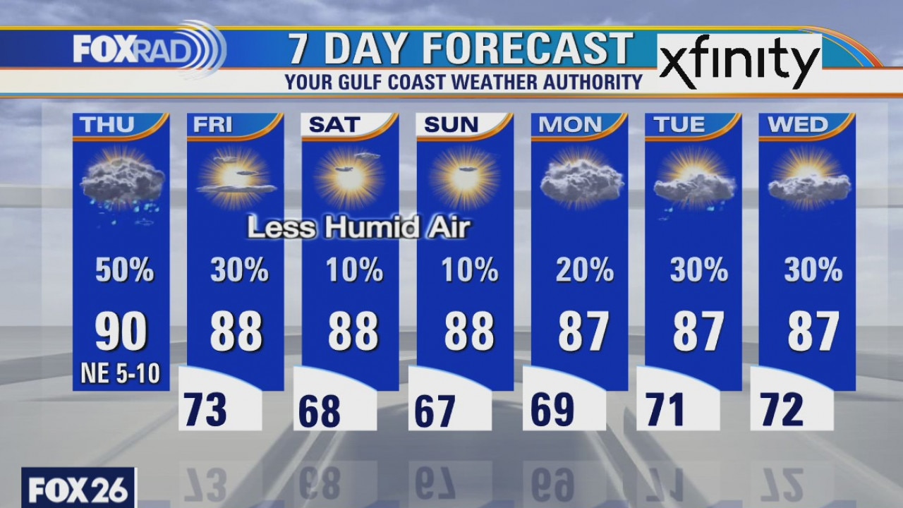
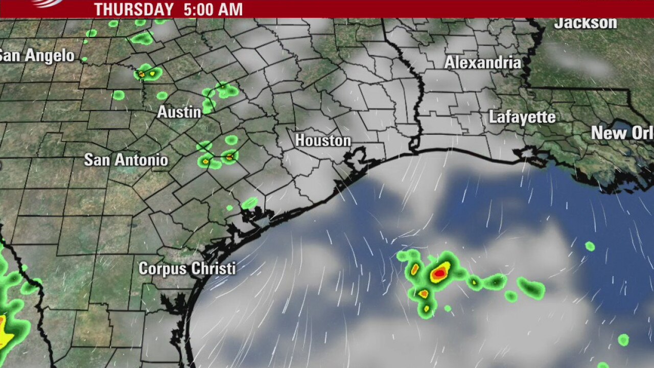
The rain chances have dropped a bit on Thur as the air over SE Texas will remain somewhat stable. The showers will mostly be west of Houston. A weak front will approach us later on Friday. That should clear things out for a beautiful weekend with lows in the upper 60s and highs in the 80s.
The rain chances have dropped a bit on Thur as the air over SE Texas will remain somewhat stable. The showers will mostly be west of Houston. A weak front will approach us later on Friday. That should clear things out for a beautiful weekend with lows in the upper 60s and highs in the 80s.
Wednesday evening weather forecast
The rain chances have dropped a bit on Thur as the air over SE Texas will remain somewhat stable. The showers will mostly be west of Houston. A weak front will approach us later on Friday. That should clear things out for a beautiful weekend with lows in the upper 60s and highs in the 80s.
The rain chances have dropped a bit on Thur as the air over SE Texas will remain somewhat stable. The showers will mostly be west of Houston. A weak front will approach us later on Friday. That should clear things out for a beautiful weekend with lows in the upper 60s and highs in the 80s.
Wednesday weather forecast
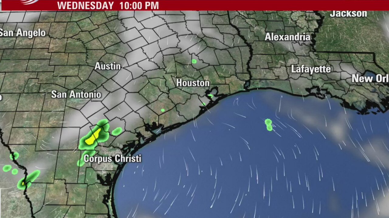
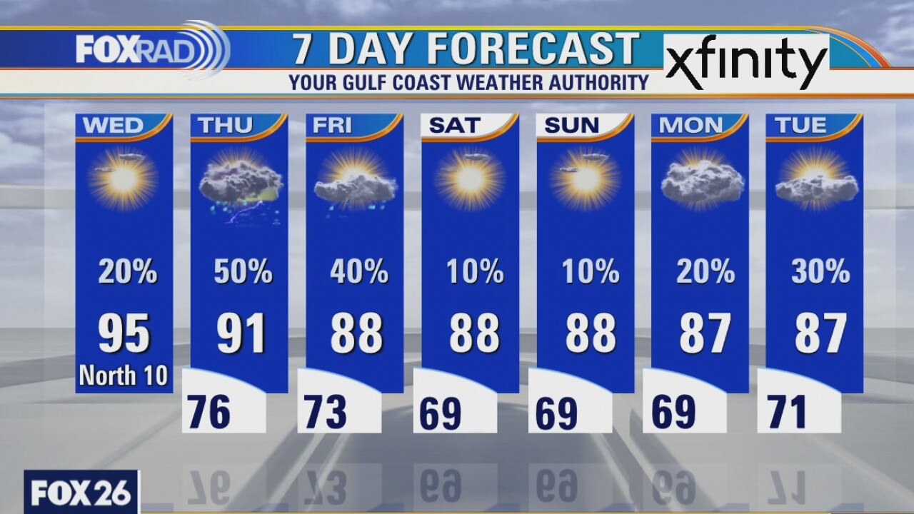
As Sally brings historic flooding to the Florida Panhandle, our weather is the complete opposite today. Watch for a few late day storms, otherwise just a mostly sunny and warm day. Temps should be slightly cooler tomorrow and Friday, then much more pleasant this weekend.
As Sally brings historic flooding to the Florida Panhandle, our weather is the complete opposite today. Watch for a few late day storms, otherwise just a mostly sunny and warm day. Temps should be slightly cooler tomorrow and Friday, then much more pleasant this weekend.
It's getting a tad cooler
It will cool a bit as we get closer to the weekend with highs in the 80s by around Friday. The best chance for rain comes on Thursday, and next week looks drier. A weak front will cool us down just a little, but we will feel a difference.
It will cool a bit as we get closer to the weekend with highs in the 80s by around Friday. The best chance for rain comes on Thursday, and next week looks drier. A weak front will cool us down just a little, but we will feel a difference.
Tuesday Weather Forecast
It will cool a bit as we get closer to the weekend with highs in the 80s by around Friday. The best chance for rain comes on Thursday and next week looks drier. A weak front will cool us down just a little, but we will feel a difference.
It will cool a bit as we get closer to the weekend with highs in the 80s by around Friday. The best chance for rain comes on Thursday and next week looks drier. A weak front will cool us down just a little, but we will feel a difference.

Tuesday weather forecast
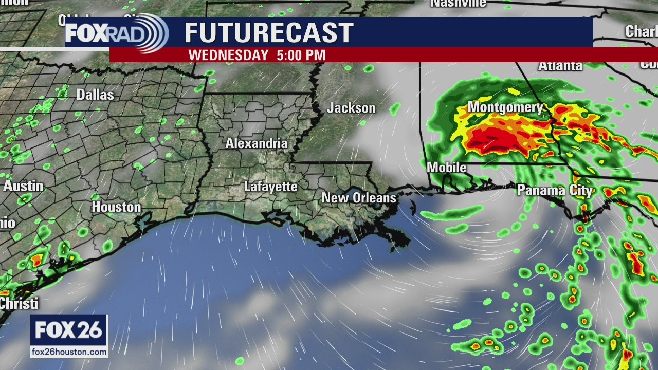
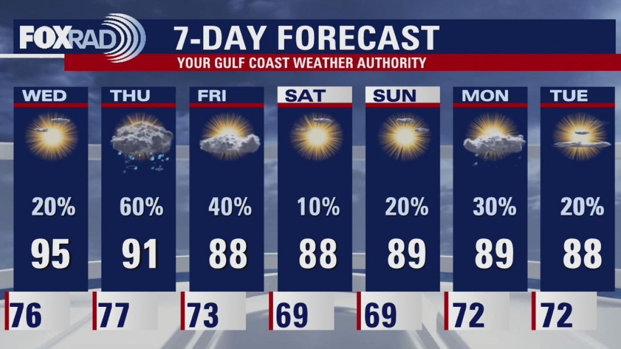
With Hurricane Sally drifting slowly toward the Alabama, Mississippi and Florida coastlines, our forecast remains hot and a bit breezy. Look for mid 90s today and tomorrow with a north breeze and a few storms. Rain chances rise in Thursday and possibly Friday with slightly cooler air. Lows could reach the 60s this weekend.
With Hurricane Sally drifting slowly toward the Alabama, Mississippi and Florida coastlines, our forecast remains hot and a bit breezy. Look for mid 90s today and tomorrow with a north breeze and a few storms. Rain chances rise in Thursday and possibly Friday with slightly cooler air. Lows could reach the 60s this weekend.