

Thursday morning weather forecast
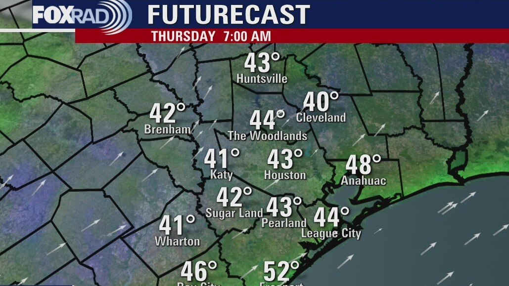
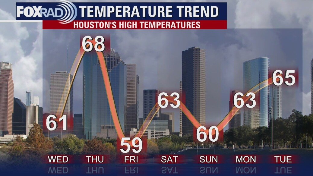
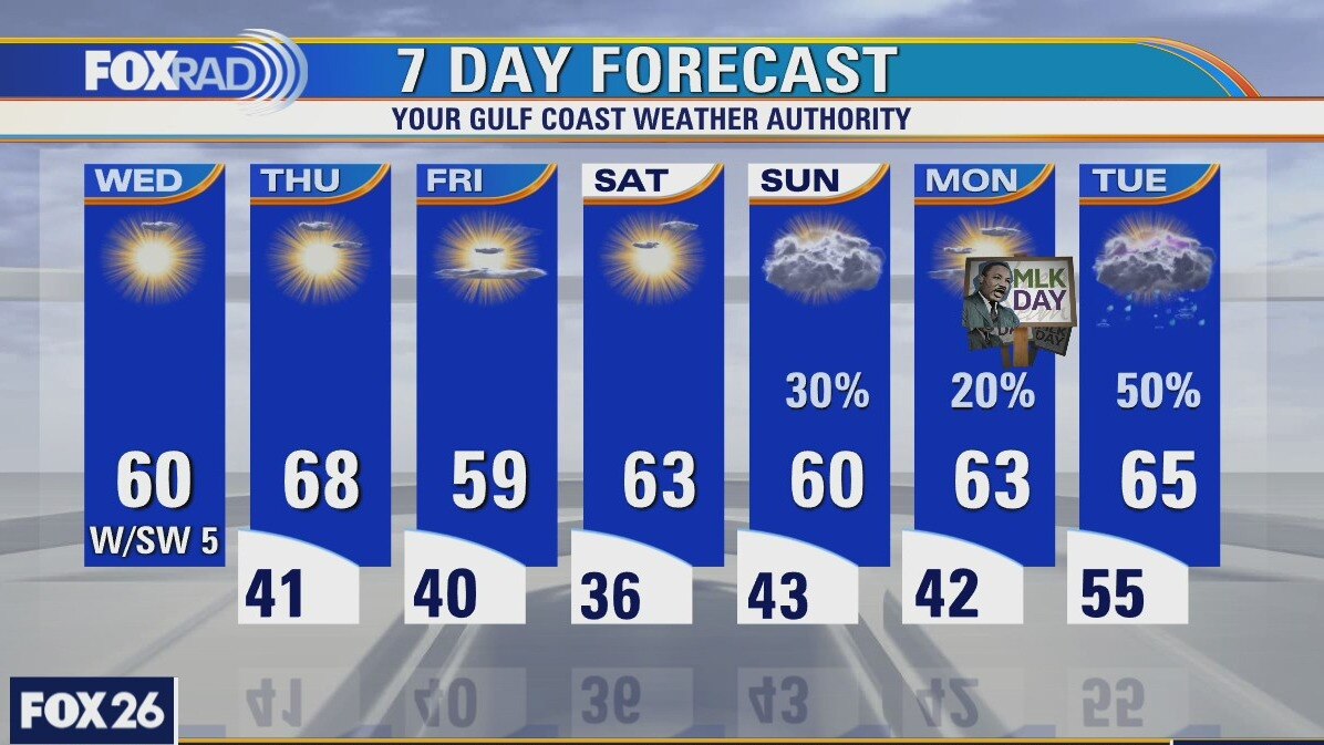
Thursday will be the warmest day of the week with highs reaching the upper 60s. A front will come through on Friday and while it won?t bring any rain, the temperatures will drop into the 50s. Look for a few showers Sunday and a much better chance for rain on Tues next week.
Thursday will be the warmest day of the week with highs reaching the upper 60s. A front will come through on Friday and while it won?t bring any rain, the temperatures will drop into the 50s. Look for a few showers Sunday and a much better chance for rain on Tues next week.
Wednesday Evening Weather Forecast
Thursday will be the warmest day of the week with highs reaching the upper 60s. A front will come through on Friday and while it won?t bring any rain, the temperatures will drop into the 50s. Look for a few showers Sunday and a much better chance for rain on Tuesday next week.
Thursday will be the warmest day of the week with highs reaching the upper 60s. A front will come through on Friday and while it won?t bring any rain, the temperatures will drop into the 50s. Look for a few showers Sunday and a much better chance for rain on Tuesday next week.
Wednesday weather forecast
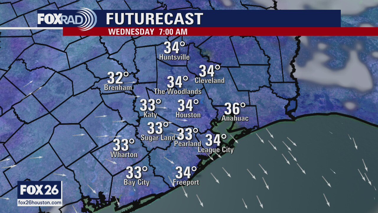
Sunshine and light southwest breezes will help temperatures warm to around 60 this afternoon, this following highs of 44 on Monday and 52 on Tuesday. Thursday's high could get close to 70, but another cold front will move through Thursday night. The next best chance for rain arrives on Sunday, then again on Tuesday with storms possible. For now, MLK Jr. Day looks seasonably cool.
Sunshine and light southwest breezes will help temperatures warm to around 60 this afternoon, this following highs of 44 on Monday and 52 on Tuesday. Thursday's high could get close to 70, but another cold front will move through Thursday night. The next best chance for rain arrives on Sunday, then again on Tuesday with storms possible. For now, MLK Jr. Day looks seasonably cool.
Wednesday morning weather forecast
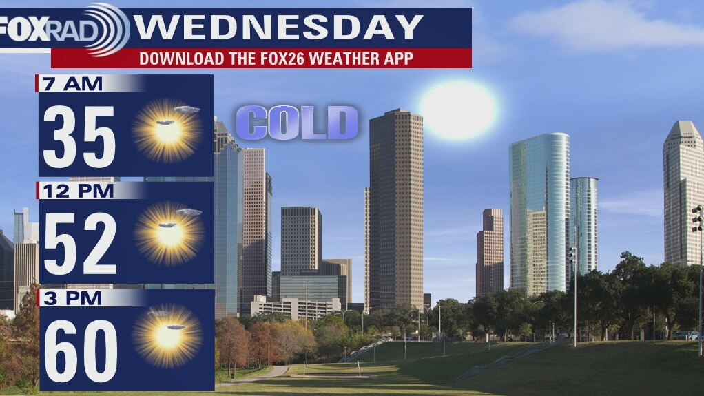
High clouds will stick around through the overnight hours, but by Wednesday morning the skies will be sunny. It will be cool to start the day with lows in the middle 30s, but it will warm into the low 60s by the afternoon. The rest of the week looks very sunny and rather nice.
High clouds will stick around through the overnight hours, but by Wednesday morning the skies will be sunny. It will be cool to start the day with lows in the middle 30s, but it will warm into the low 60s by the afternoon. The rest of the week looks very sunny and rather nice.
Tuesday Evening Weather Forecast
High clouds will stick around through the overnight hours, but by Wed morning the skies will be sunny. It will be cool to start the day with lows in the middle 30s, but it will warm into the low 60s by the afternoon. The rest of the week looks very sunny and rather nice.
High clouds will stick around through the overnight hours, but by Wed morning the skies will be sunny. It will be cool to start the day with lows in the middle 30s, but it will warm into the low 60s by the afternoon. The rest of the week looks very sunny and rather nice.
Tuesday weather forecast
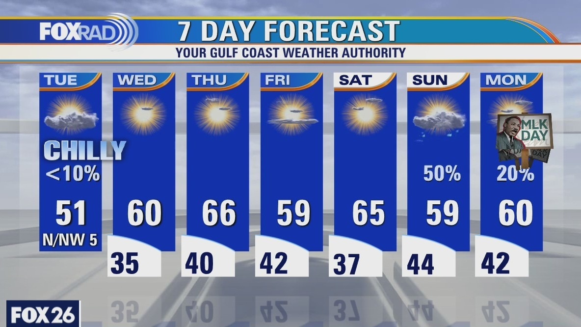
Following a cold, frosty morning, we will have another chilly day. Expect much lighter winds today with highs in the low 50s. Clouds may increase by the afternoon as well. Tonight, lows should drop into the mid 30s followed by a milder Wednesday afternoon with highs near 60. The MLK holiday weekend looks cool with rain likely on Sunday.
Following a cold, frosty morning, we will have another chilly day. Expect much lighter winds today with highs in the low 50s. Clouds may increase by the afternoon as well. Tonight, lows should drop into the mid 30s followed by a milder Wednesday afternoon with highs near 60. The MLK holiday weekend looks cool with rain likely on Sunday.
Tuesday Early Morning Weather Forecast
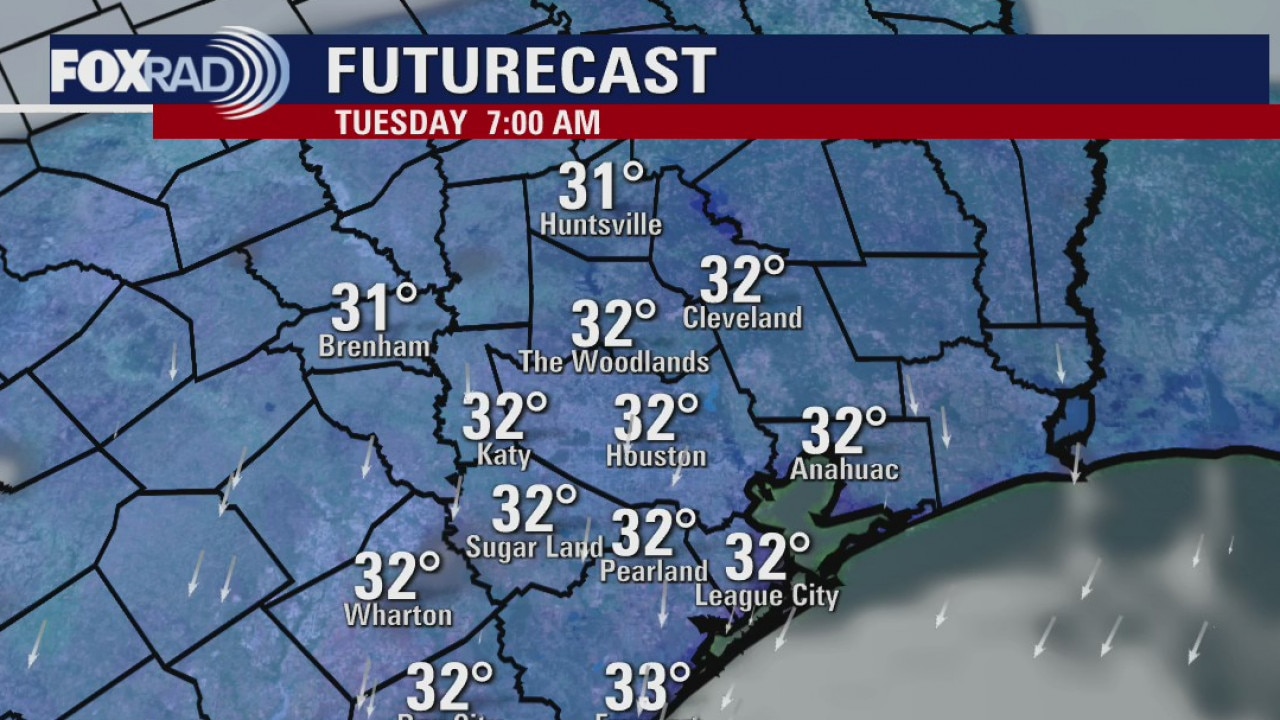
A light freeze is expected for most of SE Texas and Houston tonight and Tuesday will start a warming trend for the rest of the week. Highs will be back into the 60s by Wednesday. The next chance for rain comes on Sunday, but MLK Day looks rather nice on Monday.
A light freeze is expected for most of SE Texas and Houston tonight and Tuesday will start a warming trend for the rest of the week. Highs will be back into the 60s by Wednesday. The next chance for rain comes on Sunday, but MLK Day looks rather nice on Monday.
Monday Evening Weather Forecast
Chief Meteorologist Dr. Jim Siebert has the latest forecast for you.
Chief Meteorologist Dr. Jim Siebert has the latest forecast for you.
Monday weather forecast
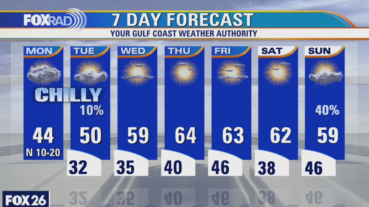
Houston just barely missed getting snow, but 4-6" of it fell from College Station to Madisonville. It will all slowly melt today as highs across Texas rise to the mid 40s. Prepare for a light freeze tonight, so protect pets and plants. The rest of the week stays chilly at night and seasonably cool during the day. The next best chance for rain arrives on Sunday.
Houston just barely missed getting snow, but 4-6" of it fell from College Station to Madisonville. It will all slowly melt today as highs across Texas rise to the mid 40s. Prepare for a light freeze tonight, so protect pets and plants. The rest of the week stays chilly at night and seasonably cool during the day. The next best chance for rain arrives on Sunday.

Houston-area weather forecast January 10th
A winter storm continues to unfold across the state of Texas with southeast Texas finding itself on the dividing line between a cold rain and accumulating snowfall. Today will be quite gloomy with temperatures basically holding steady, if not dropping, throughout the day. Rain will transition to all snow well north of Houston and could even mix over to all snow in northern portions of Harris county before the system wraps up by Monday morning. If you live south of I-10, the event will remain all rain, but the snow will not be too far away. Highest accumulations in the area look to be from Grimes to Walker to Trinity counties were 2-4" will be possible, with locally higher amounts. Totals will taper off rather quickly the farther south you head. Much colder air will filter in on Monday with lows dipping into the low 30s by Tuesday morning.
A winter storm continues to unfold across the state of Texas with southeast Texas finding itself on the dividing line between a cold rain and accumulating snowfall. Today will be quite gloomy with temperatures basically holding steady, if not dropping, throughout the day. Rain will transition to all snow well north of Houston and could even mix over to all snow in northern portions of Harris county before the system wraps up by Monday morning. If you live south of I-10, the event will remain all rain, but the snow will not be too far away. Highest accumulations in the area look to be from Grimes to Walker to Trinity counties were 2-4" will be possible, with locally higher amounts. Totals will taper off rather quickly the farther south you head. Much colder air will filter in on Monday with lows dipping into the low 30s by Tuesday morning.

Houston-area weather forecast for January 9th
Clear skies this morning have allowed temperatures to drop well into the 30s, but we should warm into the upper 50s as clouds slowly return ahead of our next system. On Sunday, most of us in southeast Texas will see a cold rain as temperatures remain in the mid 40s throughout the day, but farther to the north through Washington, Grimes, Walker and Trinity counties (where a Winter Storm Watch will go into effect at 12PM on Sunday), snow is likely with accumulations ranging from 1 to 3 inches. It?s possible a few snowflakes will try to mix in farther south, but no accumulations are expected. By Monday, the system exits but we will remain chilly. It?s not until Wednesday that we see a return to the 60s for highs.
Clear skies this morning have allowed temperatures to drop well into the 30s, but we should warm into the upper 50s as clouds slowly return ahead of our next system. On Sunday, most of us in southeast Texas will see a cold rain as temperatures remain in the mid 40s throughout the day, but farther to the north through Washington, Grimes, Walker and Trinity counties (where a Winter Storm Watch will go into effect at 12PM on Sunday), snow is likely with accumulations ranging from 1 to 3 inches. It?s possible a few snowflakes will try to mix in farther south, but no accumulations are expected. By Monday, the system exits but we will remain chilly. It?s not until Wednesday that we see a return to the 60s for highs.
Cooler weather in Houston weather
It will still be chilly in the mornings over the weekend and the afternoons will still be cool. Rain becomes likely on Sunday for all of us and a few northern counties are under a Winter Storm Watch. They could get 1-3 inches of snow. Houston is likely to have a cold rain and maybe a few flakes of sleet or snow mixed in.
It will still be chilly in the mornings over the weekend and the afternoons will still be cool. Rain becomes likely on Sunday for all of us and a few northern counties are under a Winter Storm Watch. They could get 1-3 inches of snow. Houston is likely to have a cold rain and maybe a few flakes of sleet or snow mixed in.
Friday weather forecast
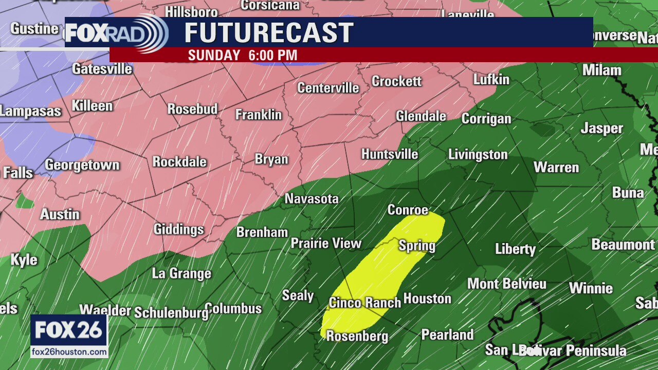
We're starting off chilly this morning with temperatures, areawide, in the upper 30s and low 40s. Winds will be lighter today, but temperatures will remain cooler with highs reaching the upper 50s and low 60s. Saturday will be similar to Friday before changes are expected on Sunday. Rain will overspread the area with temperatures remaining pretty chilly all day. It's not until late Sunday night and early Monday where we're tracking the chance for a wintry mix impact the region. The best chance of seeing snow will be well north of Houston, even north of Conroe. While we can't entirely rule out a few flakes mixing in with the rain late on Sunday; most of it will stay liquid in Houston. Temperatures slowly rebound after Monday as we dry out.
We're starting off chilly this morning with temperatures, areawide, in the upper 30s and low 40s. Winds will be lighter today, but temperatures will remain cooler with highs reaching the upper 50s and low 60s. Saturday will be similar to Friday before changes are expected on Sunday. Rain will overspread the area with temperatures remaining pretty chilly all day. It's not until late Sunday night and early Monday where we're tracking the chance for a wintry mix impact the region. The best chance of seeing snow will be well north of Houston, even north of Conroe. While we can't entirely rule out a few flakes mixing in with the rain late on Sunday; most of it will stay liquid in Houston. Temperatures slowly rebound after Monday as we dry out.
Friday morning weather forecast
It will be cool over the next couple of days with highs in the 50s and lows in the 30s. Sunday will bring another round of cold showers and a rain/snow mix is still possible north of Houston. high temps won?t reach into the 60s again until the middle of next week.
It will be cool over the next couple of days with highs in the 50s and lows in the 30s. Sunday will bring another round of cold showers and a rain/snow mix is still possible north of Houston. high temps won?t reach into the 60s again until the middle of next week.
Cooler weather over next few days
It will be cool over the next couple of days with highs in the 50s and lows in the 30s. Sunday will bring another round of cold showers and a rain/snow mix is still possible north of Houston. High temperatures won?t reach into the 60s again until the middle of next week.
It will be cool over the next couple of days with highs in the 50s and lows in the 30s. Sunday will bring another round of cold showers and a rain/snow mix is still possible north of Houston. High temperatures won?t reach into the 60s again until the middle of next week.
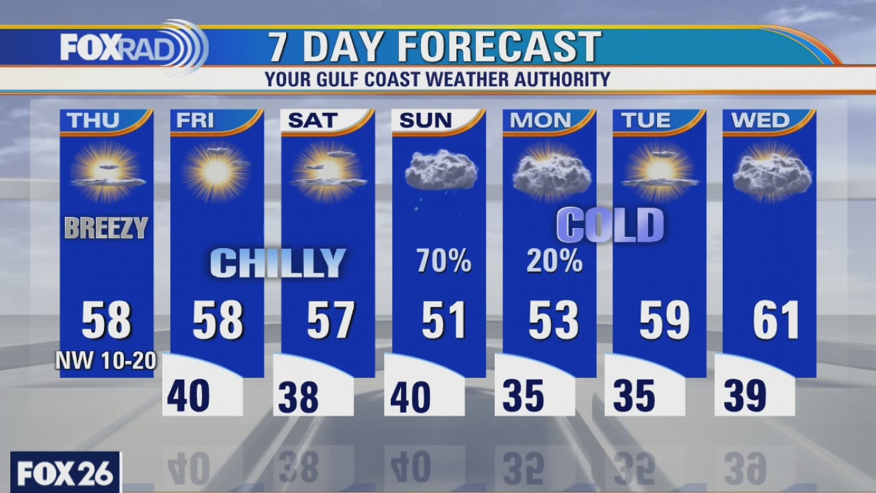
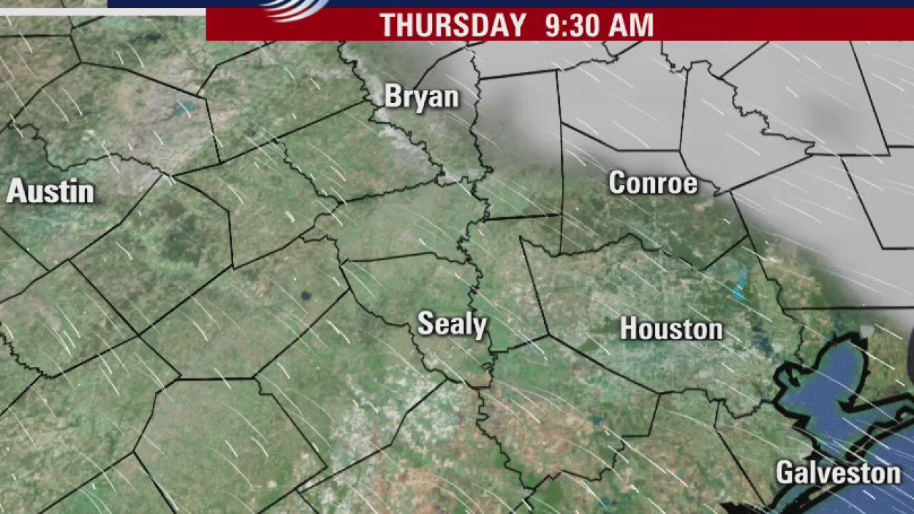
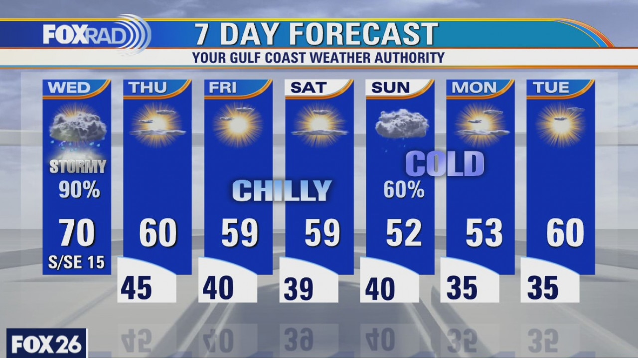
Thursday weather forecast
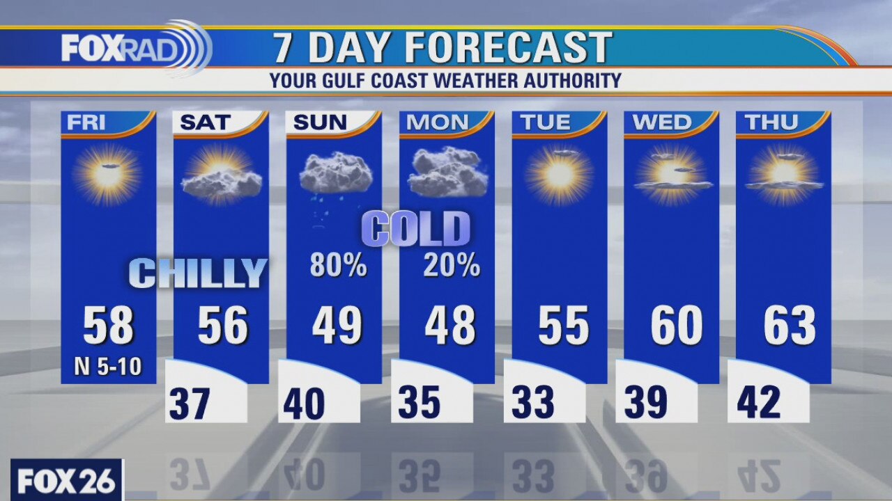
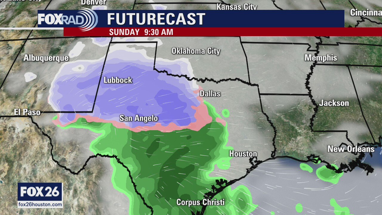
After the expected line of severe storms yesterday, we're looking for chilly and breezy weather for the next three days. Lows will drop into the upper 30s and low 40s with highs likely stuck in the upper 50s. On Sunday, a winter storm could form in NW Texas and move across the state by Sunday night. Our area will be on the edge of an area of cold rain and an area that could produce some sleet or snow. The highest chance will be north of Houston late Sunday night. The exact location is still uncertain, so stay tuned.
After the expected line of severe storms yesterday, we're looking for chilly and breezy weather for the next three days. Lows will drop into the upper 30s and low 40s with highs likely stuck in the upper 50s. On Sunday, a winter storm could form in NW Texas and move across the state by Sunday night. Our area will be on the edge of an area of cold rain and an area that could produce some sleet or snow. The highest chance will be north of Houston late Sunday night. The exact location is still uncertain, so stay tuned.
Thursday morning weather forecast
It will be cooler for the rest of the week with highs in the 50s and 60s. An area of low pressure will form near the coast on Sun. and that will help pull down more chilly air. There could be a little rain/snow mix north of Houston on Sun.
It will be cooler for the rest of the week with highs in the 50s and 60s. An area of low pressure will form near the coast on Sun. and that will help pull down more chilly air. There could be a little rain/snow mix north of Houston on Sun.
Wednesday weather forecast
Stay alert this afternoon as a cold front will likely bring a fast-moving line of storms that could be strong to severe during the mid afternoon. High winds, brief heavy rain and frequent lightning are all expected. Beginning tonight, our weather will turn breezy and chilly with lows near 40 and highs in the upper 50s. An area of low pressure on Sunday will bring a slight chance for wintry precipitation for areas north of Houston.
Stay alert this afternoon as a cold front will likely bring a fast-moving line of storms that could be strong to severe during the mid afternoon. High winds, brief heavy rain and frequent lightning are all expected. Beginning tonight, our weather will turn breezy and chilly with lows near 40 and highs in the upper 50s. An area of low pressure on Sunday will bring a slight chance for wintry precipitation for areas north of Houston.

Wednesday morning weather forecast
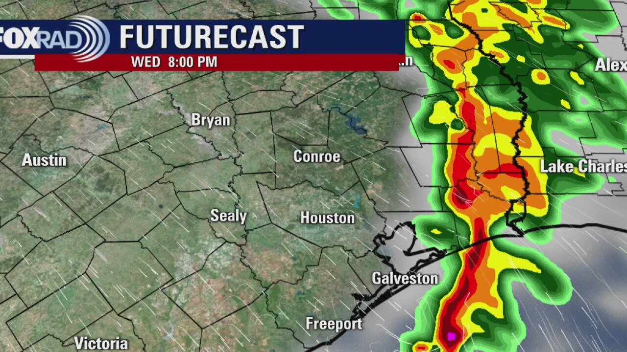
Thunderstorms will be likely by the afternoon on Wednesday as a front arrives in the Houston area. There is a marginal risk a few storms could be strong to severe. The timing will be generally between 3pm to 7pm. Most of us will just get some rain.
Thunderstorms will be likely by the afternoon on Wednesday as a front arrives in the Houston area. There is a marginal risk a few storms could be strong to severe. The timing will be generally between 3pm to 7pm. Most of us will just get some rain.
Tuesday Evening Weather Forecast
Thunderstorms will be likely by the afternoon on Wednesday as a front arrives in the Houston area. There is a marginal risk a few storms could be strong to severe. The timing will be generally between 3pm to 7pm. Most of us will just get some rain.
Thunderstorms will be likely by the afternoon on Wednesday as a front arrives in the Houston area. There is a marginal risk a few storms could be strong to severe. The timing will be generally between 3pm to 7pm. Most of us will just get some rain.