


Houston-area weather forecast: January 31st
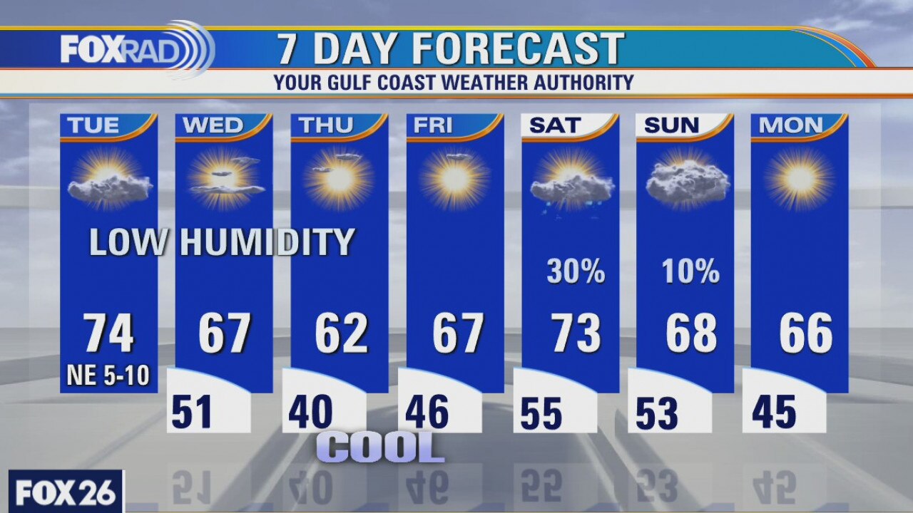
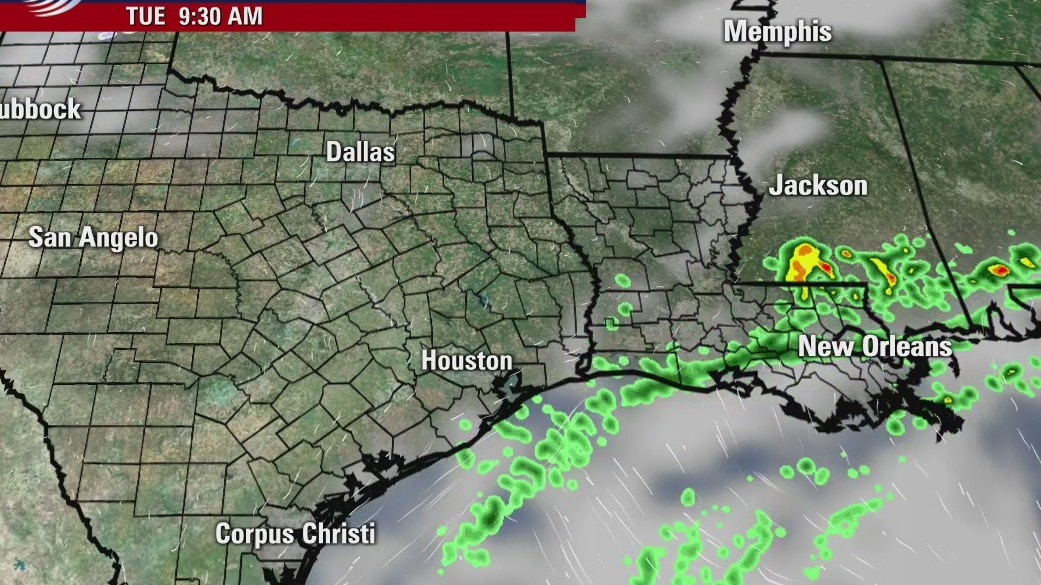
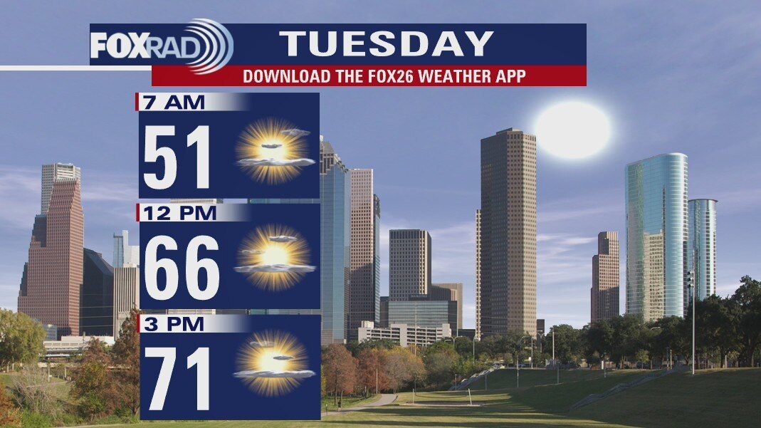
A cold front has moved through the area overnight and cooler temperatures will continue filtering in this morning. With sunny skies, we should warm into the mid 60s today, but that?s close to 10 degrees cooler than what we felt on Saturday. It?s also going to be breezy today with winds coming out of the north. February will start off chilly, but dry. Our next rain chances don?t arrive until later in the week, ramping up late on Thursday when another front will try to move in, ushering in even cooler air.
A cold front has moved through the area overnight and cooler temperatures will continue filtering in this morning. With sunny skies, we should warm into the mid 60s today, but that?s close to 10 degrees cooler than what we felt on Saturday. It?s also going to be breezy today with winds coming out of the north. February will start off chilly, but dry. Our next rain chances don?t arrive until later in the week, ramping up late on Thursday when another front will try to move in, ushering in even cooler air.
Houston-area weather forecast: January 30
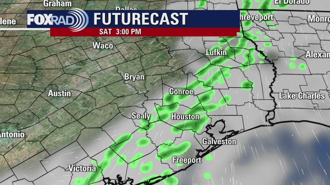
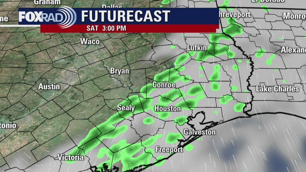
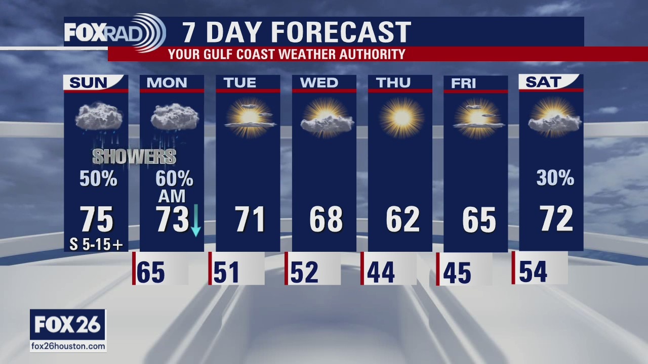
Mild weather has returned to southeast Texas, but a cold front will arrive later today and knock a few degrees off our high temperatures to round out the weekend. Rain chances will also briefly increase as that front gets closer to us. Best shot at rain will come after 3PM this afternoon. Highs, ahead of the front, will reach the mid 70s. It will also be breezy today with winds coming from the south. On Sunday, breezy conditions will continue except the wind direction will shift and come from the north. Highs, on Sunday, with mostly sunny skies will reach the mid and upper 60s.
Mild weather has returned to southeast Texas, but a cold front will arrive later today and knock a few degrees off our high temperatures to round out the weekend. Rain chances will also briefly increase as that front gets closer to us. Best shot at rain will come after 3PM this afternoon. Highs, ahead of the front, will reach the mid 70s. It will also be breezy today with winds coming from the south. On Sunday, breezy conditions will continue except the wind direction will shift and come from the north. Highs, on Sunday, with mostly sunny skies will reach the mid and upper 60s.
Saturday Morning Weather Forecast
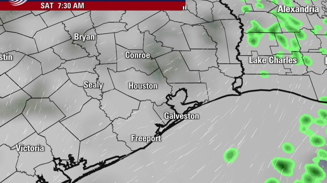
There is a good chance for scattered showers on Saturday as a front arrives in the SE Texas. It will cool things down into the 60s for highs over the next few days. It will also be rather sunny for the end of the weekend and into the coming week.
There is a good chance for scattered showers on Saturday as a front arrives in the SE Texas. It will cool things down into the 60s for highs over the next few days. It will also be rather sunny for the end of the weekend and into the coming week.
Friday Evening Weather Forecast
There is a good chance for scattered showers on Saturday as a front arrives in the SE Texas. It will cool things down into the 60s for highs over the next few days. It will also be rather sunny for the end of the weekend and into the coming week.
There is a good chance for scattered showers on Saturday as a front arrives in the SE Texas. It will cool things down into the 60s for highs over the next few days. It will also be rather sunny for the end of the weekend and into the coming week.
Friday weather forecast
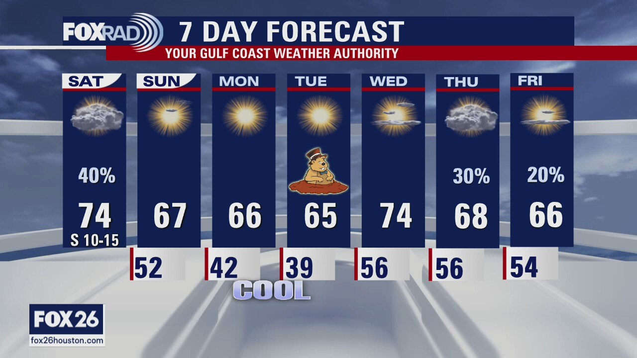
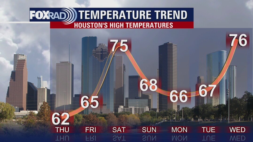
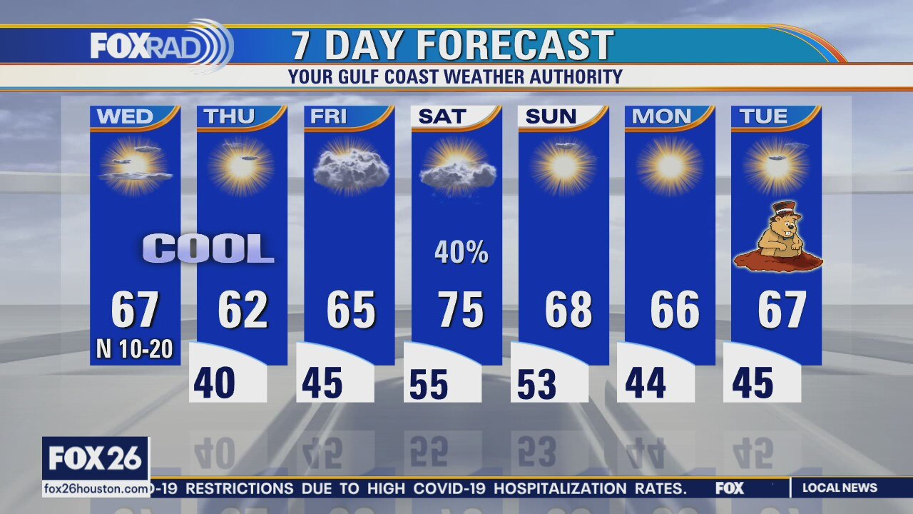
We'll wrap up the week with some normal late January weather today. Highs should reach the mid 60s, but with winds gradually returning from the southeast, drizzle and milder weather will move in overnight, Watch for scattered showers on Saturday with breezy highs in the 70s followed by a cool, dry pattern Sunday through Tuesday.
We'll wrap up the week with some normal late January weather today. Highs should reach the mid 60s, but with winds gradually returning from the southeast, drizzle and milder weather will move in overnight, Watch for scattered showers on Saturday with breezy highs in the 70s followed by a cool, dry pattern Sunday through Tuesday.
Cooler temperatures on the way
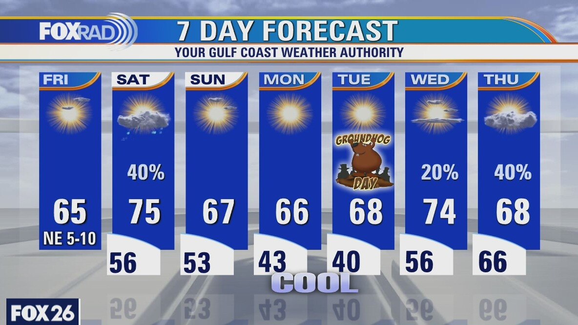
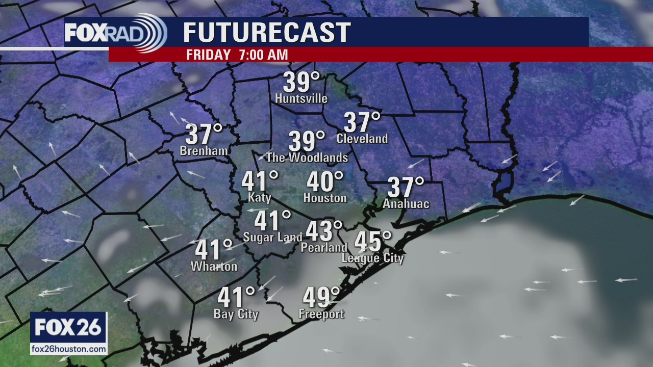
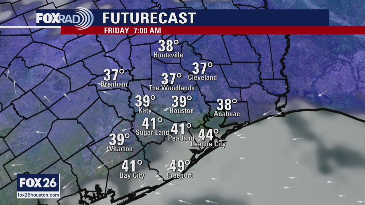
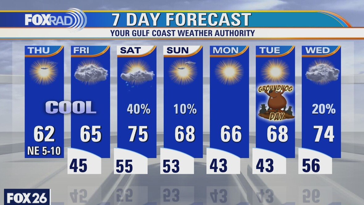
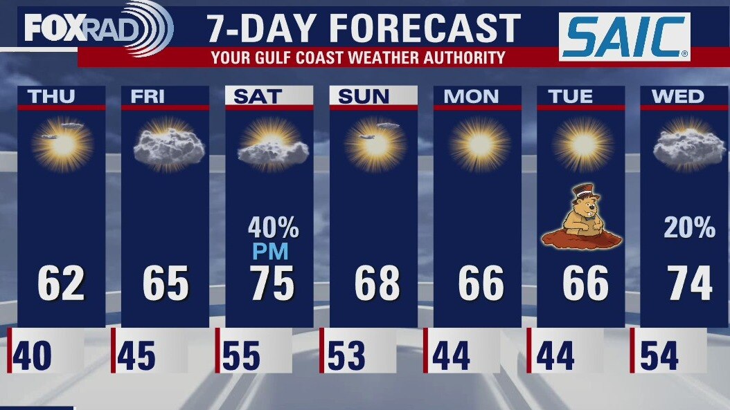
Friday will start off cool, but highs will reach the middle 60s by the afternoon. There is a 40% chance for rain mainly in the afternoon on Saturday as another front moves into the region. The first of the coming week will be a little cooler and Groundhog Day on Tuesday looks nice.
Friday will start off cool, but highs will reach the middle 60s by the afternoon. There is a 40% chance for rain mainly in the afternoon on Saturday as another front moves into the region. The first of the coming week will be a little cooler and Groundhog Day on Tuesday looks nice.
Thursday Evening Weather Forecast
Friday will start off cool, but highs will reach the middle 60s by the afternoon. There is a 40% chance for rain mainly in the afternoon on Saturday as another front moves into the region. The first of the coming week will be a little cooler and Groundhog Day on Tuesday looks nice.
Friday will start off cool, but highs will reach the middle 60s by the afternoon. There is a 40% chance for rain mainly in the afternoon on Saturday as another front moves into the region. The first of the coming week will be a little cooler and Groundhog Day on Tuesday looks nice.
Thursday weather forecast
This morning was the coolest in about a week and a half and today is looking cool and dry. We'll stay cool tomorrow, then a south breeze should bring milder air and scattered showers on Saturday. Sunday through Tuesday look dry with seasonably cool temperatures.
This morning was the coolest in about a week and a half and today is looking cool and dry. We'll stay cool tomorrow, then a south breeze should bring milder air and scattered showers on Saturday. Sunday through Tuesday look dry with seasonably cool temperatures.
Thursday morning weather forecast
Low temps will drop into the 30s tonight around the Houston area, but should remain just above freezing. Highs on Thursday will reach the low 60s and only a few degrees below normal for this time of year. It will also be mostly sunny.
Low temps will drop into the 30s tonight around the Houston area, but should remain just above freezing. Highs on Thursday will reach the low 60s and only a few degrees below normal for this time of year. It will also be mostly sunny.
Wednesday Evening Weather Forecast
Tonight will be the coldest night of the week with Lows dipping into the upper 30s and low 40s. Thursday brings plenty of sunshine, but highs only reach into the low 60s. The next chance for rain comes on Saturday afternoon as another front moves into the area.
Tonight will be the coldest night of the week with Lows dipping into the upper 30s and low 40s. Thursday brings plenty of sunshine, but highs only reach into the low 60s. The next chance for rain comes on Saturday afternoon as another front moves into the area.
Wednesday weather forecast
Mostly sunny, breezy and cool with highs in the upper 60s.
Mostly sunny, breezy and cool with highs in the upper 60s.
Wednesday morning weather forecast
A front will move across SE Texas on Wednesday and will help cool things down for the rest of the work week. The next chance for rain comes on Saturday when another front arrives and that will cool us down for the first part of the coming week. It?s not too bad for January.
A front will move across SE Texas on Wednesday and will help cool things down for the rest of the work week. The next chance for rain comes on Saturday when another front arrives and that will cool us down for the first part of the coming week. It?s not too bad for January.
Tuesday Evening Weather Forecast
A front will move across SE Texas on Wednesday and will help cool things down for the rest of the work week. The next chance for rain comes on Saturday when another front arrives and that will cool us down for the first part of the coming week. It?s not too bad for January.
A front will move across SE Texas on Wednesday and will help cool things down for the rest of the work week. The next chance for rain comes on Saturday when another front arrives and that will cool us down for the first part of the coming week. It?s not too bad for January.
Tuesday weather forecast
Cooler and drier air has arrived and will bring pleasant weather for the rest of the week. Look for highs today in the mid 70s with a partly cloudy sky. Tonight will bring upper 40s and low 50s with even cooler air Thursday morning with lows near 40. Afternoons will be mostly sunny and cool. The next chance for area wide showers is on Saturday.
Cooler and drier air has arrived and will bring pleasant weather for the rest of the week. Look for highs today in the mid 70s with a partly cloudy sky. Tonight will bring upper 40s and low 50s with even cooler air Thursday morning with lows near 40. Afternoons will be mostly sunny and cool. The next chance for area wide showers is on Saturday.
Tuesday morning weather forecast
The gloomy weather is about to change after a front pushes through SE Texas today. The sunshine will return and it will be a bit cooler until the weekend. Our next best chance for rainfall comes early on Saturday, but will be gone by Sunday.
The gloomy weather is about to change after a front pushes through SE Texas today. The sunshine will return and it will be a bit cooler until the weekend. Our next best chance for rainfall comes early on Saturday, but will be gone by Sunday.
Monday Evening Weather Forecast
The gloomy weather is about to change after a front pushes through SE Texas today. The sunshine will return and it will be a bit cooler until the weekend. Our next best chance for rainfall comes early on Saturday, but will be gone by Sunday.
The gloomy weather is about to change after a front pushes through SE Texas today. The sunshine will return and it will be a bit cooler until the weekend. Our next best chance for rainfall comes early on Saturday, but will be gone by Sunday.
Monday weather forecast
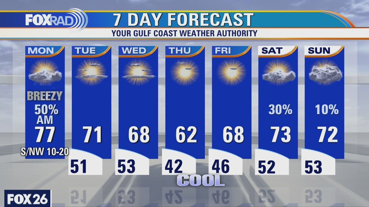
After a breezy, soupy morning, look for midday and early afternoon showers followed by a big pattern change. Drier air will begin moving in late today behind a cold front, so the rest of the week will look and feel much different than the last few days. Look for lows in the 40s and 50s with highs in the 60s and low 70s. Sunshine will return for most of the week along with low humidity.
After a breezy, soupy morning, look for midday and early afternoon showers followed by a big pattern change. Drier air will begin moving in late today behind a cold front, so the rest of the week will look and feel much different than the last few days. Look for lows in the 40s and 50s with highs in the 60s and low 70s. Sunshine will return for most of the week along with low humidity.
Houston-area weather forecast: January 24th
One of our foggiest mornings of the past several is this morning with an areawide dense fog advisory until 12PM. Our coastal counties will carry that advisory until 6PM. Showers will be possible throughout the morning, but somewhat drier conditions will filter in this afternoon. The cold front should arrive on Monday morning with skies gradually clearing behind it. Fog and mist and drizzle will be hanging around, though, until that front moves through. Highs will reach the low 70s, even after the front moves through. Our cooler weather won't likely arrive until Wednesday into Thursday where highs will drop back into the low and mid 60s...where we should be this time of year.
One of our foggiest mornings of the past several is this morning with an areawide dense fog advisory until 12PM. Our coastal counties will carry that advisory until 6PM. Showers will be possible throughout the morning, but somewhat drier conditions will filter in this afternoon. The cold front should arrive on Monday morning with skies gradually clearing behind it. Fog and mist and drizzle will be hanging around, though, until that front moves through. Highs will reach the low 70s, even after the front moves through. Our cooler weather won't likely arrive until Wednesday into Thursday where highs will drop back into the low and mid 60s...where we should be this time of year.

Houston-area weather forecast: January 23rd
It?s clear that we remain stuck in this weather pattern of sea fog and mild temperatures. These conditions will continue through the weekend, but rain chances will begin to increase tonight into Sunday. Highs on Saturday will likely reach the upper 60s and while warmer weather is expected on Sunday, scattered showers will be more likely. Conditions will finally improve after Monday when a cold front moves through. In fact, it?s possible we could see some sun as early as Monday afternoon. While a cold front will clear us of the sea fog, temperatures will still remain on the milder side with chillier mornings expected beginning on Tuesday.
It?s clear that we remain stuck in this weather pattern of sea fog and mild temperatures. These conditions will continue through the weekend, but rain chances will begin to increase tonight into Sunday. Highs on Saturday will likely reach the upper 60s and while warmer weather is expected on Sunday, scattered showers will be more likely. Conditions will finally improve after Monday when a cold front moves through. In fact, it?s possible we could see some sun as early as Monday afternoon. While a cold front will clear us of the sea fog, temperatures will still remain on the milder side with chillier mornings expected beginning on Tuesday.
Saturday morning weather forecast
It will be cloudy and misty over the weekend with the best chance for rain later Saturday and into Sunday. Monday starts off with drizzle, but will begin to clear later in the day. Tuesday could actually bring partly cloudy skies. It?s something to look forward to next week.
It will be cloudy and misty over the weekend with the best chance for rain later Saturday and into Sunday. Monday starts off with drizzle, but will begin to clear later in the day. Tuesday could actually bring partly cloudy skies. It?s something to look forward to next week.