

Thursday evening weather forecast
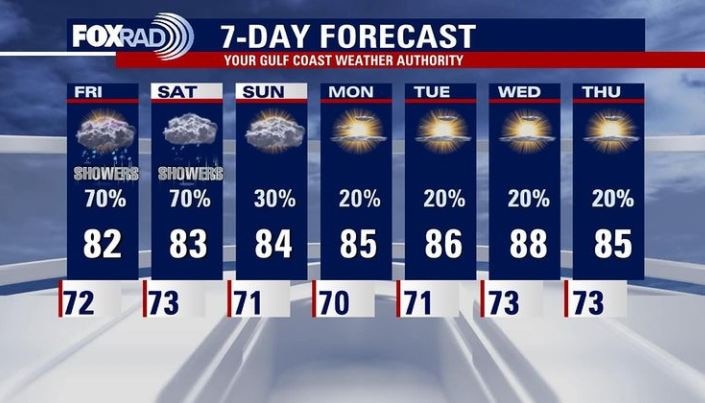
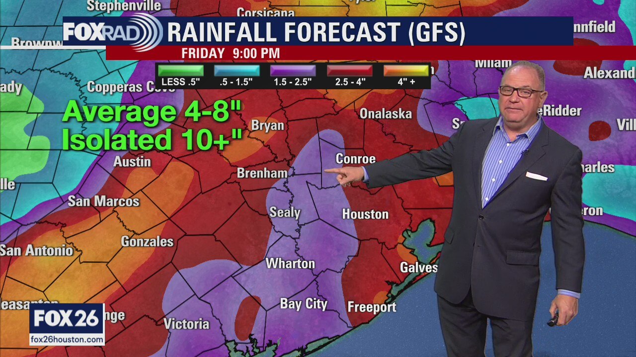
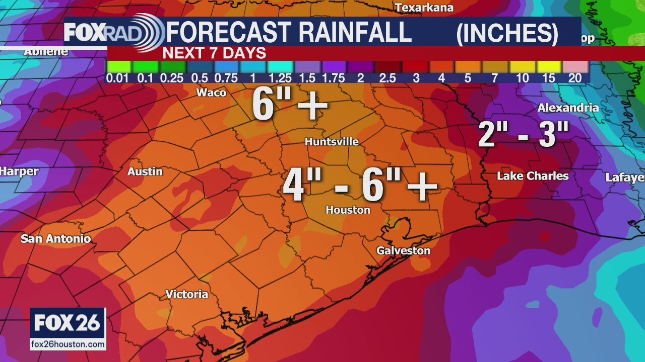
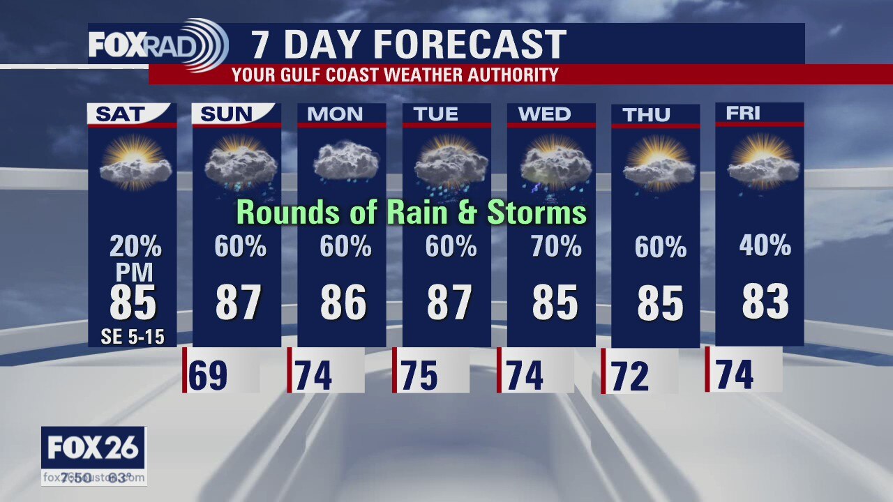
The risk for flooding has dropped, but showers are likely through Saturday. An area of high pressure to our east will push more humidity into SE Texas and that means scattered showers and a few storms. It will be a bit drier starting Sunday and into the coming week.
The risk for flooding has dropped, but showers are likely through Saturday. An area of high pressure to our east will push more humidity into SE Texas and that means scattered showers and a few storms. It will be a bit drier starting Sunday and into the coming week.

Thursday weather forecast
Patches of fog and drizzle this morning will give way to a mostly cloudy sky with afternoon showers a possibility. It's also possible we'll see peeks of sun throughout the day so temperatures will likely warm more than they did on Wednesday; highs should reach the low 80s. Rain chances will remain on the higher side through Saturday, but conditions look to be improving by Sunday. We finally have a reasonable opportunity to dry out then. Highs will likely near 90 degrees by the end of next week.
Patches of fog and drizzle this morning will give way to a mostly cloudy sky with afternoon showers a possibility. It's also possible we'll see peeks of sun throughout the day so temperatures will likely warm more than they did on Wednesday; highs should reach the low 80s. Rain chances will remain on the higher side through Saturday, but conditions look to be improving by Sunday. We finally have a reasonable opportunity to dry out then. Highs will likely near 90 degrees by the end of next week.

Thursday weather forecast
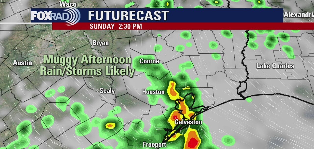
Cloudy this morning with scattered showers and storms possible by this afternoon. Highs in the low 80s.
Cloudy this morning with scattered showers and storms possible by this afternoon. Highs in the low 80s.

Thursday morning weather forecast
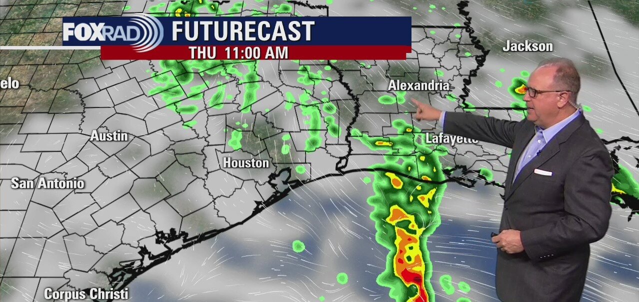
The Flash Flood Watch continues for SE Texas until 1pm Thursday, but the rain has been a bit more manageable for most areas except in our coastal counties. The coming week does look drier, but there will still be a risk for a few showers. High temps will also be warm and it will feel like the 90s with the humidity.
The Flash Flood Watch continues for SE Texas until 1pm Thursday, but the rain has been a bit more manageable for most areas except in our coastal counties. The coming week does look drier, but there will still be a risk for a few showers. High temps will also be warm and it will feel like the 90s with the humidity.
Wednesday Evening Weather Forecast
We know more rain is in the forecast but is it looking a little better for some of us now? Our Chief Meteorologist Dr. Jim Siebert has more with Your Gulf Coast Weather Authority Forecast.
We know more rain is in the forecast but is it looking a little better for some of us now? Our Chief Meteorologist Dr. Jim Siebert has more with Your Gulf Coast Weather Authority Forecast.

Wednesday weather forecast
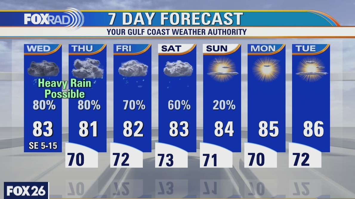
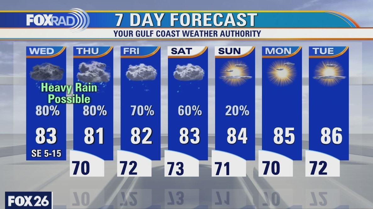
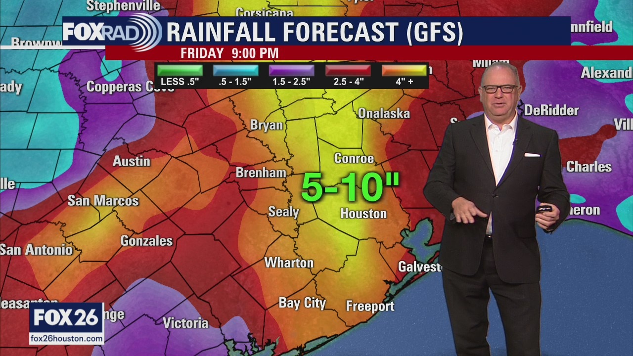
The Flash Flood Watch has been extended for Southeast Texas until 1pm on Thursday. Houston could still see several more rounds of heavy downpours. Be on the lookout for street flooding. Rain stays in the forecast for the start of the weekend.
The Flash Flood Watch has been extended for Southeast Texas until 1pm on Thursday. Houston could still see several more rounds of heavy downpours. Be on the lookout for street flooding. Rain stays in the forecast for the start of the weekend.
Wednesday weather forecast
The Flash Flood Watch has been extended for Southeast Texas until 1pm on Thursday. Houston could still see several more rounds of heavy downpours. Be on the lookout for street flooding. Rain stays in the forecast for the start of the weekend.
The Flash Flood Watch has been extended for Southeast Texas until 1pm on Thursday. Houston could still see several more rounds of heavy downpours. Be on the lookout for street flooding. Rain stays in the forecast for the start of the weekend.
Wednesday weather forecast
The Flash Flood Watch has been extended for Southeast Texas until 1 pm on Thursday. Houston could still see several more rounds of heavy downpours. Be on the lookout for street flooding. Rain stays in the forecast for the start of the weekend.
The Flash Flood Watch has been extended for Southeast Texas until 1 pm on Thursday. Houston could still see several more rounds of heavy downpours. Be on the lookout for street flooding. Rain stays in the forecast for the start of the weekend.
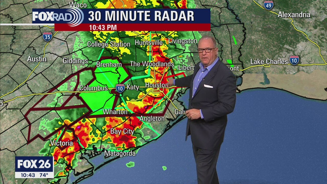
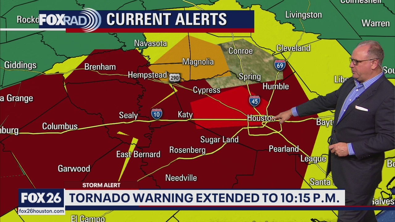
Severe Weather Update
Your Gulf Coast Weather Authority Chief Meteorologist Dr. Jim Siebert has the latest storms moving through the Houston area.
Your Gulf Coast Weather Authority Chief Meteorologist Dr. Jim Siebert has the latest storms moving through the Houston area.
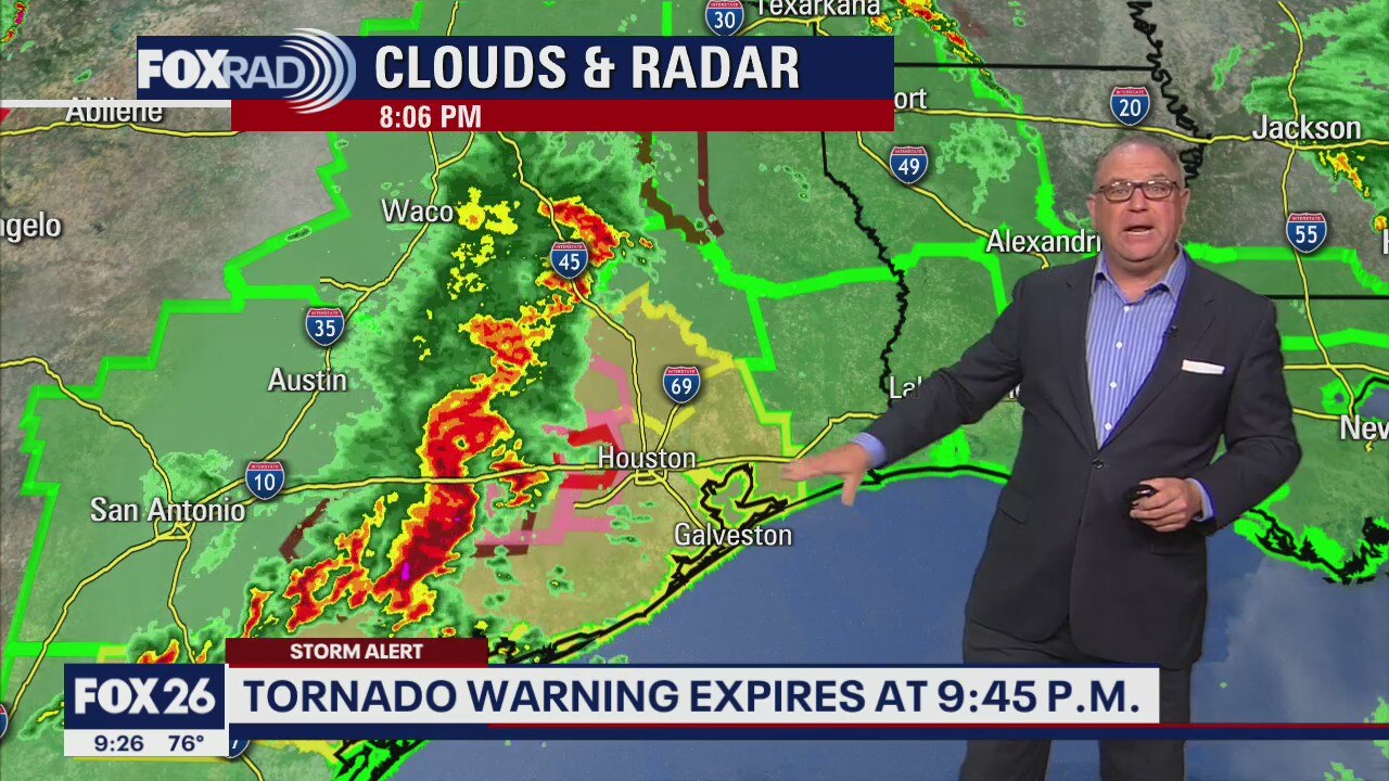
Severe Weather Update
Your Gulf Coast Weather Authority Chief Meteorologist Dr. Jim Siebert has the latest on severe weather moving through southeast Texas.
Your Gulf Coast Weather Authority Chief Meteorologist Dr. Jim Siebert has the latest on severe weather moving through southeast Texas.
Severe Weather Update
Your Gulf Coast Weather Authority Chief Meteorologist Dr. Jim Siebert has the latest on storms moving through the Houston area.
Your Gulf Coast Weather Authority Chief Meteorologist Dr. Jim Siebert has the latest on storms moving through the Houston area.
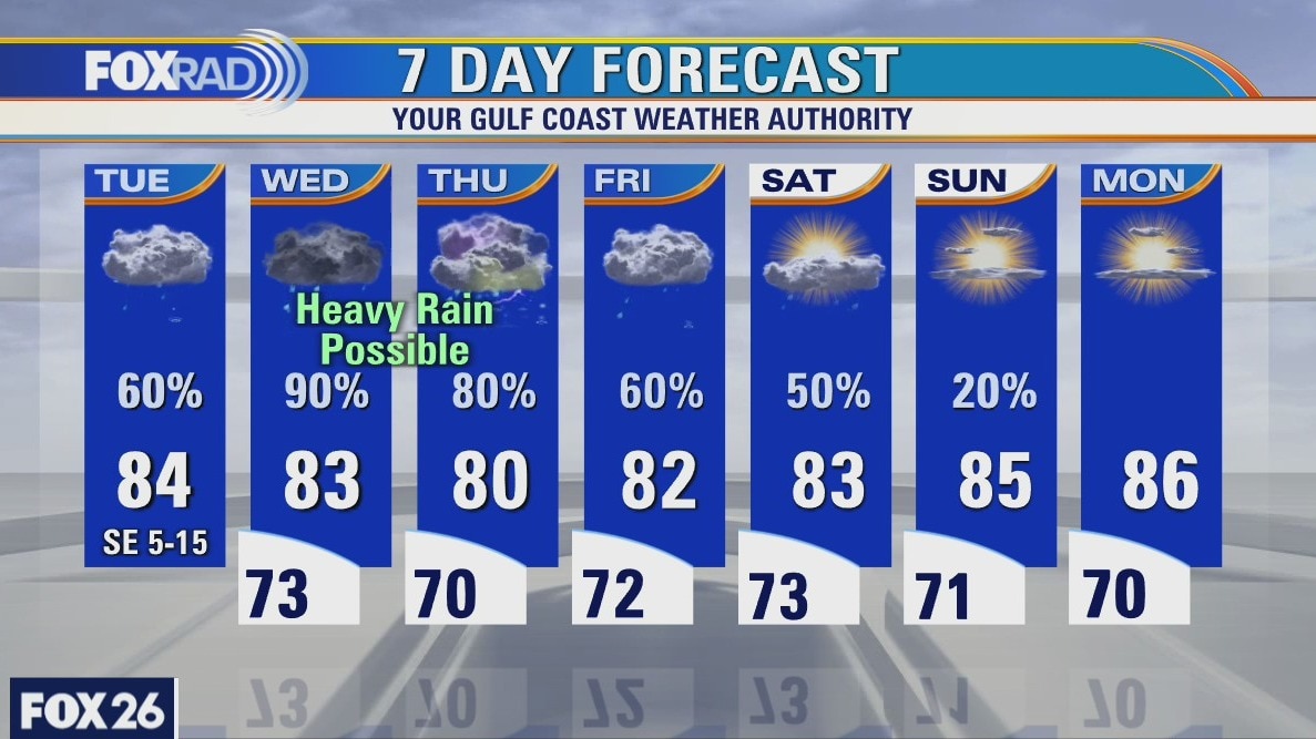
Tuesday Evening Weather Forecast
More showers and storms are expected Wednesday and the rest of the week. The area of low pressure is moving, but it is still close enough to keep the rain chances high and the Flash Flood Watch remains until 7am Thursday. It may be extended, because the humidity will still be in place and showers will be more likely than not.
More showers and storms are expected Wednesday and the rest of the week. The area of low pressure is moving, but it is still close enough to keep the rain chances high and the Flash Flood Watch remains until 7am Thursday. It may be extended, because the humidity will still be in place and showers will be more likely than not.
Tuesday weather forecast
Mild this morning with showers and storms likely in the afternoon. A few storms could produce heavy rain. Highs in the low to mid 80s.
Mild this morning with showers and storms likely in the afternoon. A few storms could produce heavy rain. Highs in the low to mid 80s.

Tuesday Morning Weather Forecast
There is always light at the end of a storm and while we remain under a Flash Flood Watch until 7am Thursday, this picture from Susan Neilson in Katy makes me feel peaceful. Stay weather alert over the next few days.
There is always light at the end of a storm and while we remain under a Flash Flood Watch until 7am Thursday, this picture from Susan Neilson in Katy makes me feel peaceful. Stay weather alert over the next few days.
Monday Evening Weather Forecast
Heavy rainfall is likely on-and-off through at least Friday and that means flooding risks will continue for all of SE Texas and the Houston area. The air will remain very humid and the low causing all of this will stay off to our northwest. It will finally move by Thursday, but it will drag a weak front across the region. That will lead to some of the possibly heaviest rainfall from Wednesday into Thursday and a Flash Flood Watch is posted until 7am Thursday.
Heavy rainfall is likely on-and-off through at least Friday and that means flooding risks will continue for all of SE Texas and the Houston area. The air will remain very humid and the low causing all of this will stay off to our northwest. It will finally move by Thursday, but it will drag a weak front across the region. That will lead to some of the possibly heaviest rainfall from Wednesday into Thursday and a Flash Flood Watch is posted until 7am Thursday.
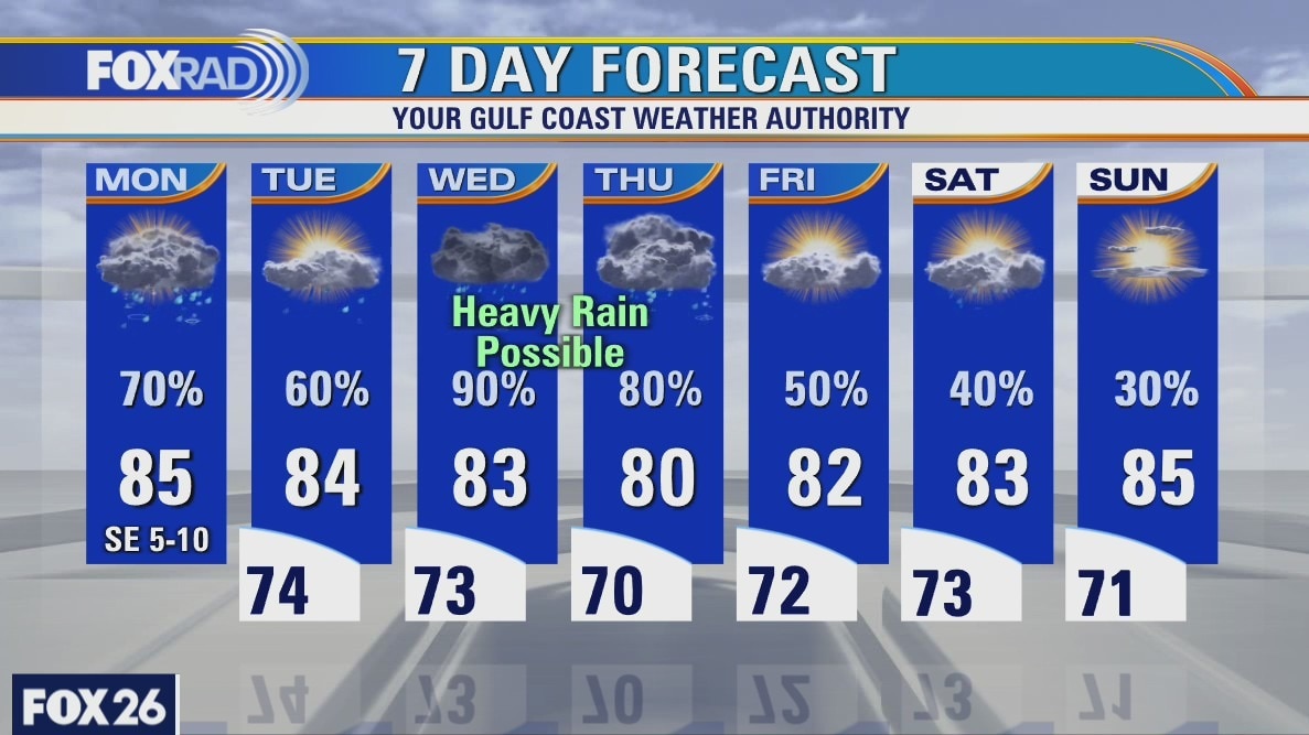
Monday weather forecast
Showers and storms are expected to develop later this morning into the afternoon with most of the Houston-area likely seeing rain. Some of the rain this afternoon could be heavy and given the rain we saw yesterday, a few spots could experience some minor flooding. Our flood threat will increase as we work toward the middle of the week as more rain falls. While it's difficult to pinpoint exactly where the heaviest of rain will fall, the threat exists for all of us living here in southeast Texas. Rain chances will taper off as we head toward Friday and Saturday.
Showers and storms are expected to develop later this morning into the afternoon with most of the Houston-area likely seeing rain. Some of the rain this afternoon could be heavy and given the rain we saw yesterday, a few spots could experience some minor flooding. Our flood threat will increase as we work toward the middle of the week as more rain falls. While it's difficult to pinpoint exactly where the heaviest of rain will fall, the threat exists for all of us living here in southeast Texas. Rain chances will taper off as we head toward Friday and Saturday.
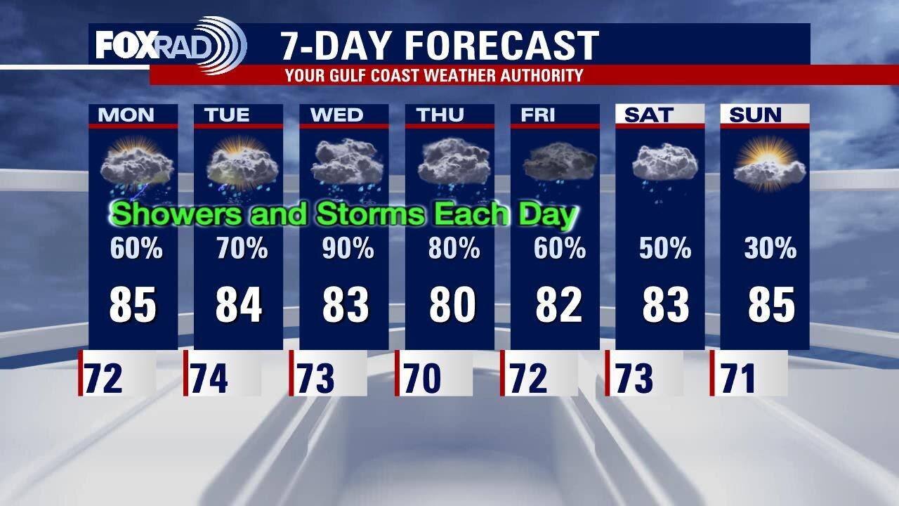
Sunday Evening Weather Forecast
Several upper-level disturbances will pass through the Houston area this week bringing a chance of showers and storms every day this week.
Several upper-level disturbances will pass through the Houston area this week bringing a chance of showers and storms every day this week.
Houston-area weather forecast 5/16
Rainy times ahead for the Houston-area beginning on Sunday. Temperatures will remain mild, but stay below average as rain chances increase Sunday afternoon. Meanwhile, rain chances will remain on the high side, each day, for the entire week. It won?t be raining all the time, but several inches of rain will be possible by next Sunday. As it looks now, our greatest chance of seeing heavy rain will be on Wednesday.
Rainy times ahead for the Houston-area beginning on Sunday. Temperatures will remain mild, but stay below average as rain chances increase Sunday afternoon. Meanwhile, rain chances will remain on the high side, each day, for the entire week. It won?t be raining all the time, but several inches of rain will be possible by next Sunday. As it looks now, our greatest chance of seeing heavy rain will be on Wednesday.
Saturday Evening Weather Forecast
Our Meteorologist John Dawson tells you what to be on the lookout for with your Fox 26 Weather.
Our Meteorologist John Dawson tells you what to be on the lookout for with your Fox 26 Weather.
Houston-area weather forecast 5/15
After a couple of days with pleasant temperatures and drier air, humidity is returning to southeast Texas today. Temperatures will warm well into the 80s this afternoon, but we should remain mostly dry. Rain chances ramp up tomorrow as showers and storms will be likely throughout the day. Rain chances continue into the work week and remain on the higher side until at least Thursday. While it won't be raining all day, we'll see multiple rounds of rain and storms throughout the week.
After a couple of days with pleasant temperatures and drier air, humidity is returning to southeast Texas today. Temperatures will warm well into the 80s this afternoon, but we should remain mostly dry. Rain chances ramp up tomorrow as showers and storms will be likely throughout the day. Rain chances continue into the work week and remain on the higher side until at least Thursday. While it won't be raining all day, we'll see multiple rounds of rain and storms throughout the week.