

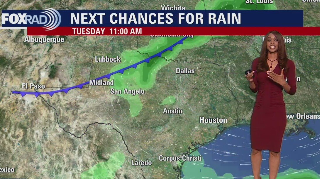
Tuesday morning weather forecast
It's a beautiful start to the week with lots of sunshine and warm temperatures. Moisture will increase by Tuesday and Wednesday ahead of a weak cold front that arrives early Thursday. A 30-40% chance for showers will be with us Midweek. A stronger cold front arrives late Sunday into early Monday that could bring more widespread rain and a bigger drop in temperatures. Julia is no longer a tropical cyclone but is bringing heavy rain to parts of Guatemala and S. Mexico. Another disturbance over the Yucatan Peninsula has a low chance for development over the next few days.
It's a beautiful start to the week with lots of sunshine and warm temperatures. Moisture will increase by Tuesday and Wednesday ahead of a weak cold front that arrives early Thursday. A 30-40% chance for showers will be with us Midweek. A stronger cold front arrives late Sunday into early Monday that could bring more widespread rain and a bigger drop in temperatures. Julia is no longer a tropical cyclone but is bringing heavy rain to parts of Guatemala and S. Mexico. Another disturbance over the Yucatan Peninsula has a low chance for development over the next few days.

Monday evening weather forecast
It's a beautiful start to the week with lots of sunshine and warm temperatures. Moisture will increase by Tuesday and Wednesday ahead of a weak cold front that arrives early Thursday. A 30-40% chance for showers will be with us Midweek. A stronger cold front arrives late Sunday into early Monday that could bring more widespread rain and a bigger drop in temperatures. Julia is no longer a tropical cyclone but is bringing heavy rain to parts of Guatemala and S. Mexico. Another disturbance over the Yucatan Peninsula has a low chance for development over the next few days.
It's a beautiful start to the week with lots of sunshine and warm temperatures. Moisture will increase by Tuesday and Wednesday ahead of a weak cold front that arrives early Thursday. A 30-40% chance for showers will be with us Midweek. A stronger cold front arrives late Sunday into early Monday that could bring more widespread rain and a bigger drop in temperatures. Julia is no longer a tropical cyclone but is bringing heavy rain to parts of Guatemala and S. Mexico. Another disturbance over the Yucatan Peninsula has a low chance for development over the next few days.
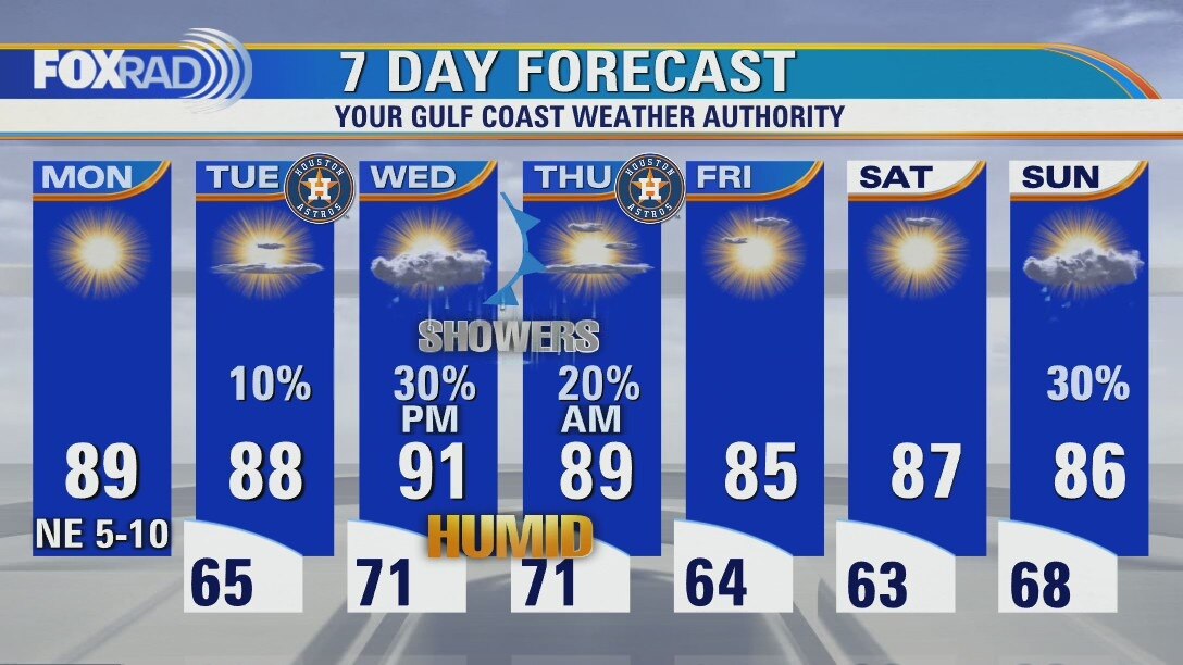
Another pleasant day, with lots of sunshine Monday
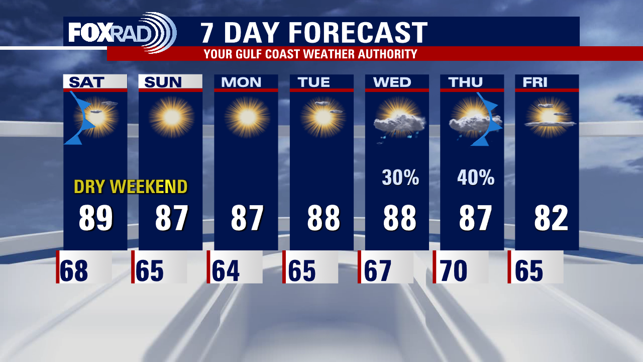
Starting off the week with a continuation of our near perfect streak of weather. Onshore flow will slowly return, with building humidity by the middle of the week. As we transition towards those more humid conditions, we may squeeze out a sprinkle or brief shower Tuesday. Chances have decreased some for midweek rain, but some showers still look to be about as a weak front slides through overnight Wednesday into Thursday morning. That will lead to a dry start to the weekend, with some more showers possible on Sunday. Models continue to hint at a more potent front arriving on the 16th/17th so we'll keep our eyes on that and fine tune details as things draws closer.
Starting off the week with a continuation of our near perfect streak of weather. Onshore flow will slowly return, with building humidity by the middle of the week. As we transition towards those more humid conditions, we may squeeze out a sprinkle or brief shower Tuesday. Chances have decreased some for midweek rain, but some showers still look to be about as a weak front slides through overnight Wednesday into Thursday morning. That will lead to a dry start to the weekend, with some more showers possible on Sunday. Models continue to hint at a more potent front arriving on the 16th/17th so we'll keep our eyes on that and fine tune details as things draws closer.
Sunday night leading into Monday morning weather forecast
A cool front is on the way, but we'll have to wait until Thursday night to feel the arrival of refreshing air. In the meantime, expect warm days with a slight increase in humidity Monday and Tuesday. Our best chance for showers comes along with the front from late Wednesday into Thursday morning. Otherwise, our weather looks pretty quiet. Hurricane Julia hit Nicaragua overnight Saturday and brought very heavy rain - the system will cross Central America and will briefly maintain its status as Tropical Storm Julia in the Pacific ocean before weakening along the coast of Guatemala and Mexico.
A cool front is on the way, but we'll have to wait until Thursday night to feel the arrival of refreshing air. In the meantime, expect warm days with a slight increase in humidity Monday and Tuesday. Our best chance for showers comes along with the front from late Wednesday into Thursday morning. Otherwise, our weather looks pretty quiet. Hurricane Julia hit Nicaragua overnight Saturday and brought very heavy rain - the system will cross Central America and will briefly maintain its status as Tropical Storm Julia in the Pacific ocean before weakening along the coast of Guatemala and Mexico.

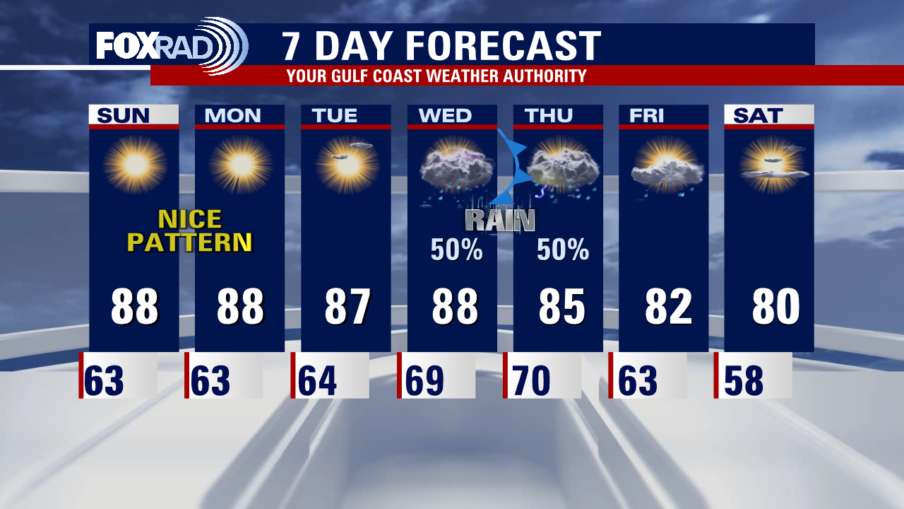
Sunday Morning Forecast with Meteorologist Lena Maria Arango
Quiet, pleasant weather will linger through the start of the week with humidity building by Wednesday. Our next front looks to arrive by Thursday, interacting with remnant moisture from Hurricane Julia providing a much-needed boost in rain chances. Conditions look to improve for game 2 of the ALDS Thursday evening, with dry air draining in to start the weekend. Another front may swing through on Sunday bringing some more showers to close out the weekend.
Quiet, pleasant weather will linger through the start of the week with humidity building by Wednesday. Our next front looks to arrive by Thursday, interacting with remnant moisture from Hurricane Julia providing a much-needed boost in rain chances. Conditions look to improve for game 2 of the ALDS Thursday evening, with dry air draining in to start the weekend. Another front may swing through on Sunday bringing some more showers to close out the weekend.
Saturday night leading into Sunday morning weather forecast
FOX 26 is your Gulf Coast Weather Authority and Chief Meteorologist Mike Iscovitz gives us a look at our weekend forecast.
FOX 26 is your Gulf Coast Weather Authority and Chief Meteorologist Mike Iscovitz gives us a look at our weekend forecast.
Your Saturday Morning Forecast with Meteorologist Lena Maria
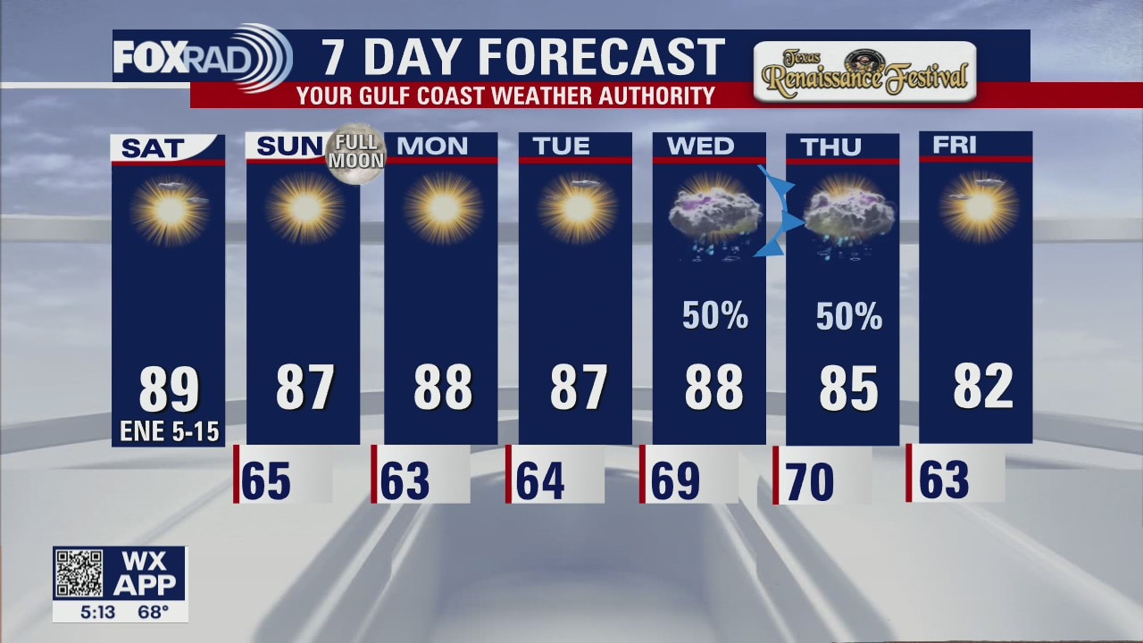
Blissful weather continues for now, which is great news for a busy weekend and week for events and sports in Houston. Middle of next week, a stronger fall front looks to collide with leftover moisture from Julia finally bringing a promising chance for rain. It also looks to bring a much more potent dose of cooler, drier air with lows falling into the 50s for most of us by next Saturday.
Blissful weather continues for now, which is great news for a busy weekend and week for events and sports in Houston. Middle of next week, a stronger fall front looks to collide with leftover moisture from Julia finally bringing a promising chance for rain. It also looks to bring a much more potent dose of cooler, drier air with lows falling into the 50s for most of us by next Saturday.
Saturday morning weather forecast
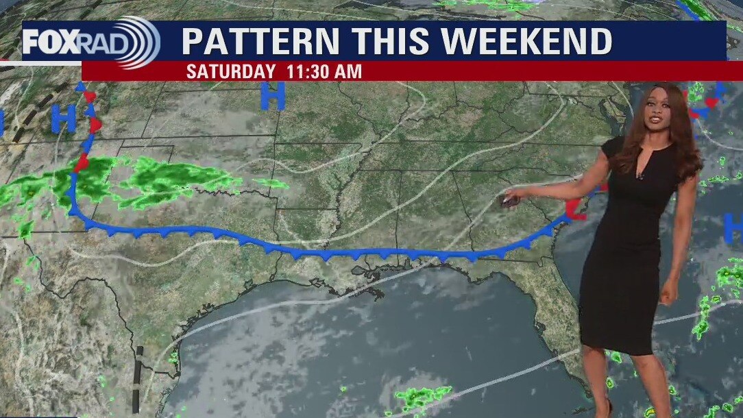
Weak cold front will be dropping into the area tonight through early Saturday. It's bringing thicker clouds and there may be a few sprinkles but no major rain is expected. Clouds should clear for the weekend and it will be breezy Saturday but not quite as hot and dry. Sunday will be bright and dry also. Pattern shifts next week as moisture from what's left of Julia and a stronger cold front will combine to increase our rain and storm chances by Wednesday and Thursday.
Weak cold front will be dropping into the area tonight through early Saturday. It's bringing thicker clouds and there may be a few sprinkles but no major rain is expected. Clouds should clear for the weekend and it will be breezy Saturday but not quite as hot and dry. Sunday will be bright and dry also. Pattern shifts next week as moisture from what's left of Julia and a stronger cold front will combine to increase our rain and storm chances by Wednesday and Thursday.
Friday evening weather forecast with Meteorologist Remeisha Shade
Weak cold front will be dropping into the area tonight through early Saturday. It's bringing thicker clouds and there may be a few sprinkles but no major rain is expected. Clouds should clear for the weekend and it will be breezy Saturday but not quite as hot and dry. Sunday will be bright and dry also. Pattern shifts next week as moisture from what's left of Julia and a stronger cold front will combine to increase our rain and storm chances by Wednesday and Thursday.
Weak cold front will be dropping into the area tonight through early Saturday. It's bringing thicker clouds and there may be a few sprinkles but no major rain is expected. Clouds should clear for the weekend and it will be breezy Saturday but not quite as hot and dry. Sunday will be bright and dry also. Pattern shifts next week as moisture from what's left of Julia and a stronger cold front will combine to increase our rain and storm chances by Wednesday and Thursday.
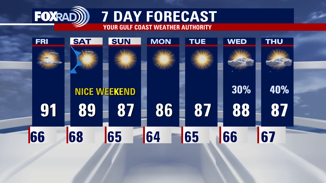
Another warm, dry day Friday with highs in the low 90s
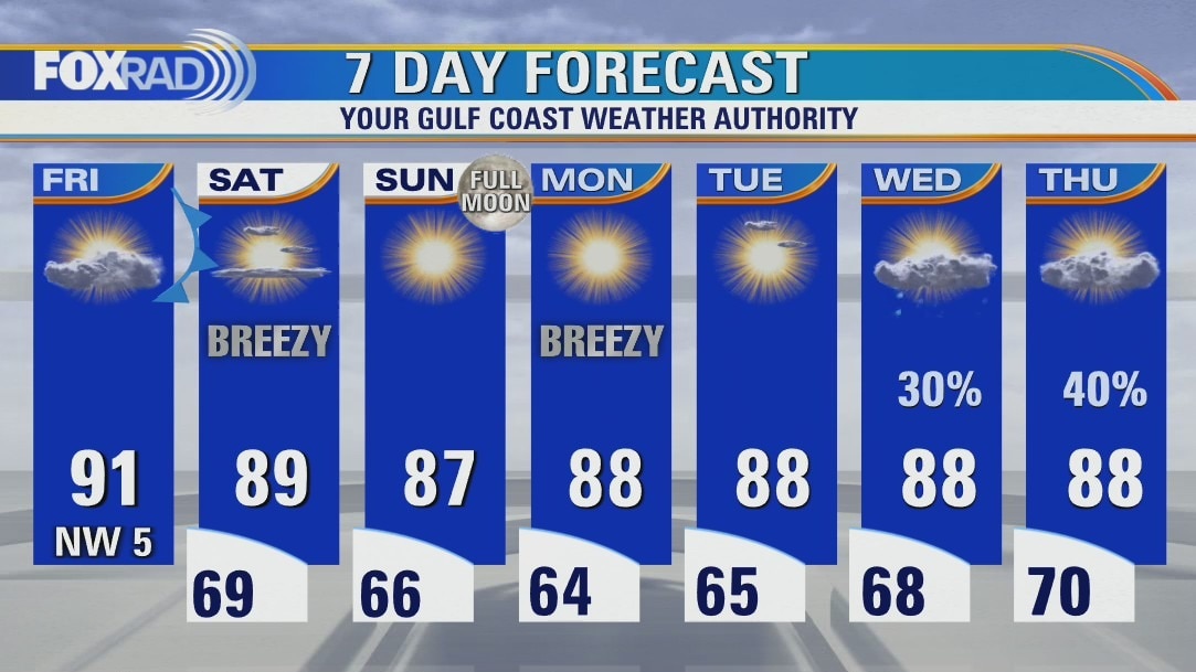
Heading into the long weekend on a warm note, with more cloud cover and another air quality alert for ozone. By tomorrow morning, a weak front will have cleared the coastline and north breezes will quickly scatter out any leftover clouds as drier, cooler air drains in. Sunny, dry weather with near seasonable temperatures will linger until middle of next week, when a combination of another approaching front and leftover moisture from now TD13 will bring us the best rain chances we have seen in a while.
Heading into the long weekend on a warm note, with more cloud cover and another air quality alert for ozone. By tomorrow morning, a weak front will have cleared the coastline and north breezes will quickly scatter out any leftover clouds as drier, cooler air drains in. Sunny, dry weather with near seasonable temperatures will linger until middle of next week, when a combination of another approaching front and leftover moisture from now TD13 will bring us the best rain chances we have seen in a while.
Friday weather forecast
Friday will be another warm, dry day with highs in the low 90s and a bit more cloudiness.
Friday will be another warm, dry day with highs in the low 90s and a bit more cloudiness.
Friday morning weather forecast
A few changes are finally showing up in our extended forecast. For the short term, it will be more warm and dry weather that will prevail. A weak cold front will arrive late Friday that will knock temperatures down a few degrees for the weekend. Moisture gradually increases mid-late next week from a tropical system south and an approaching cold front. That means rain chances are increasing by Wednesday and Thursday.
A few changes are finally showing up in our extended forecast. For the short term, it will be more warm and dry weather that will prevail. A weak cold front will arrive late Friday that will knock temperatures down a few degrees for the weekend. Moisture gradually increases mid-late next week from a tropical system south and an approaching cold front. That means rain chances are increasing by Wednesday and Thursday.
Thursday evening weather forecast with Meteorologist Remeisha Shade
A few changes are finally showing up in our extended forecast. For the short term, it will be more warm and dry weather that will prevail. A weak cold front will arrive late Friday that will knock temperatures down a few degrees for the weekend. Moisture gradually increases mid-late next week from a tropical system south and an approaching cold front. That means rain chances are increasing by Wednesday and Thursday.
A few changes are finally showing up in our extended forecast. For the short term, it will be more warm and dry weather that will prevail. A weak cold front will arrive late Friday that will knock temperatures down a few degrees for the weekend. Moisture gradually increases mid-late next week from a tropical system south and an approaching cold front. That means rain chances are increasing by Wednesday and Thursday.
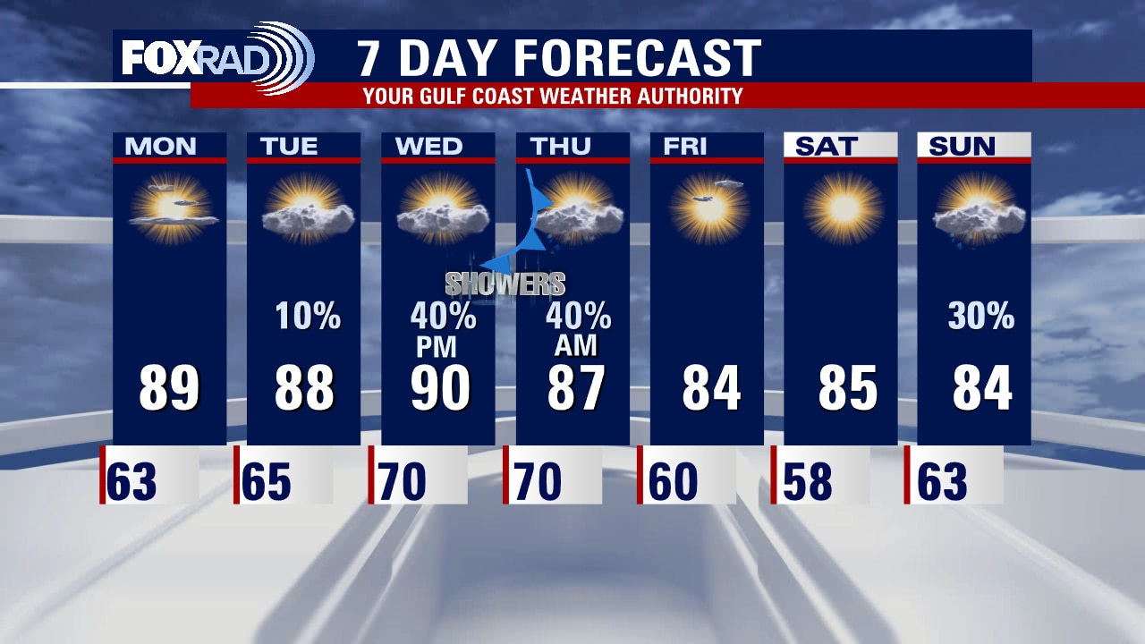
More sunny and dry conditions Thursday afternoon, rain chances next week
Of the last 30 days, 21 of them have seen air quality alerts issued for ozone and today is no exception. Sunny, dry weather continues for now. Cloud cover may increase some as a weak surface front works its way across the area, but it won't shake up our pattern all that much. It will however put a halt to the increasing temperatures and humidity. As a plus, clear skies will provide great views of our October full moon on Sunday! Our next front, paired with better rain chances looks to arrive middle of next week. No tropical cyclone development is expected in the Pacific in the next 2-5 days. In the Atlantic, Potential Tropical Cyclone 13 (formerly Invest 91-L) has formed and is marching west toward Central America. The Gulf has no tropical concerns at this time.
Of the last 30 days, 21 of them have seen air quality alerts issued for ozone and today is no exception. Sunny, dry weather continues for now. Cloud cover may increase some as a weak surface front works its way across the area, but it won't shake up our pattern all that much. It will however put a halt to the increasing temperatures and humidity. As a plus, clear skies will provide great views of our October full moon on Sunday! Our next front, paired with better rain chances looks to arrive middle of next week. No tropical cyclone development is expected in the Pacific in the next 2-5 days. In the Atlantic, Potential Tropical Cyclone 13 (formerly Invest 91-L) has formed and is marching west toward Central America. The Gulf has no tropical concerns at this time.

Another warm, dry, sunny day with an air quality alert for ozone
Of the last 30 days, 21 of them have seen air quality alerts issued for ozone and today is no exception. Sunny, dry weather continues for now. Cloud cover may increase some as a weak surface front works its way across the area, but it won't shake up our pattern all that much. It will, however put a halt to the increasing temperatures and humidity nudging that down ever so slightly. As a plus, clear skies will provide great views of our October full moon on Sunday! Our next front, paired with better rain chances looks to arrive middle of next week. Paine has dissipated in the tropical Pacific with no further cyclone development expected in the next 2-5 days. In the tropical Atlantic, TD-12 is holding on but barely, and Invest 91-L is marching westward bringing heavy rain, flooding potential, and gusty winds to the ABC islands and eventually Central America. The Gulf has no tropical concerns at this time.
Of the last 30 days, 21 of them have seen air quality alerts issued for ozone and today is no exception. Sunny, dry weather continues for now. Cloud cover may increase some as a weak surface front works its way across the area, but it won't shake up our pattern all that much. It will, however put a halt to the increasing temperatures and humidity nudging that down ever so slightly. As a plus, clear skies will provide great views of our October full moon on Sunday! Our next front, paired with better rain chances looks to arrive middle of next week. Paine has dissipated in the tropical Pacific with no further cyclone development expected in the next 2-5 days. In the tropical Atlantic, TD-12 is holding on but barely, and Invest 91-L is marching westward bringing heavy rain, flooding potential, and gusty winds to the ABC islands and eventually Central America. The Gulf has no tropical concerns at this time.

Thursday morning weather forecast
Another stellar weather day is in progress for SE Texas with a good supply of sunshine and warm temperatures in the 80s to near 90. Look for more of the same through the weekend. Weak cool front will bring a little relief from the heat for the weekend but no rain is expected. Moisture builds back in next week with a better chance for a few showers and storms showing up by next Wednesday.
Another stellar weather day is in progress for SE Texas with a good supply of sunshine and warm temperatures in the 80s to near 90. Look for more of the same through the weekend. Weak cool front will bring a little relief from the heat for the weekend but no rain is expected. Moisture builds back in next week with a better chance for a few showers and storms showing up by next Wednesday.
Wednesday evening weather forecast
Another stellar weather day is in progress for SE Texas with a good supply of sunshine and warm temperatures in the 80s to near 90. Look for more of the same through the weekend. Weak cool front will bring a little relief from the heat for the weekend but no rain is expected. Moisture builds back in next week with a better chance for a few showers and storms showing up by next Wednesday.
Another stellar weather day is in progress for SE Texas with a good supply of sunshine and warm temperatures in the 80s to near 90. Look for more of the same through the weekend. Weak cool front will bring a little relief from the heat for the weekend but no rain is expected. Moisture builds back in next week with a better chance for a few showers and storms showing up by next Wednesday.
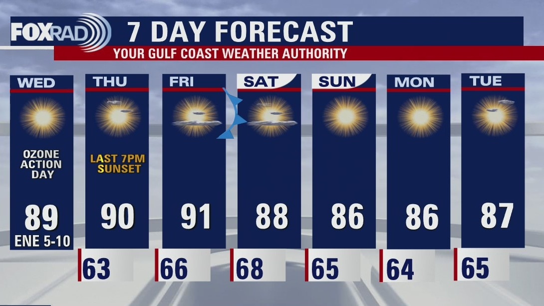
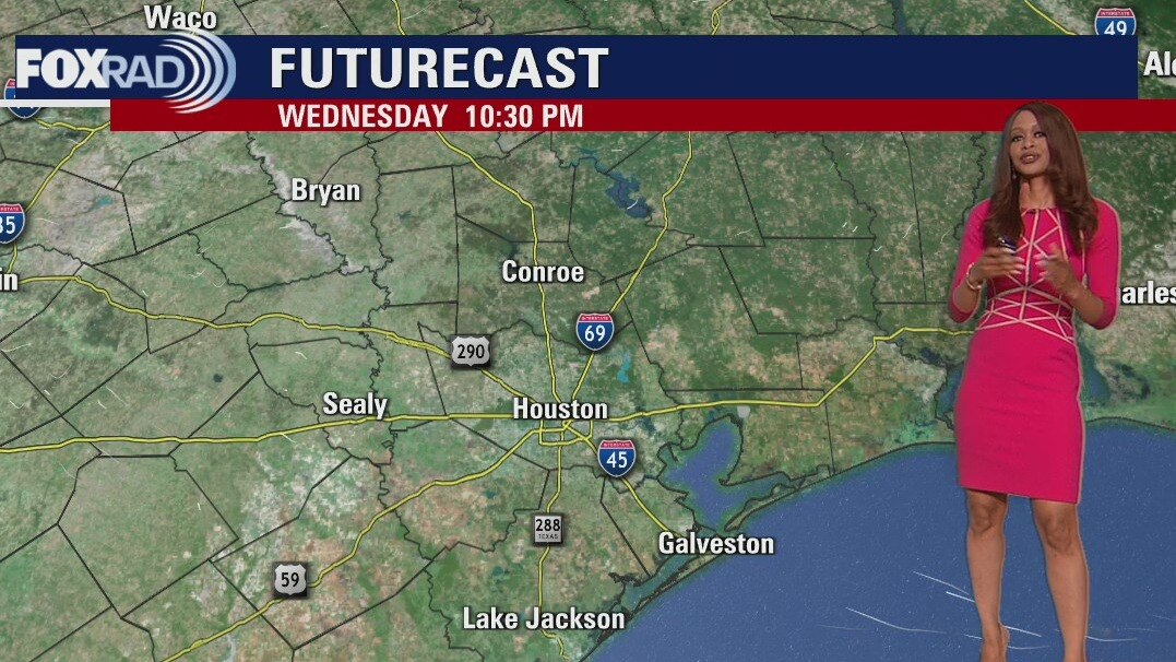
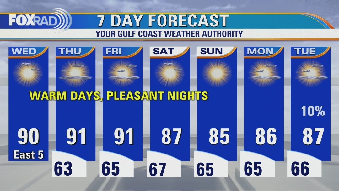
Staying warm, sunny, and in 80s this Wednesday afternoon
Our sunny, dry weather has been blissful but it's led to problematic air quality in particular for sensitive groups. Temperatures and humidity will continue to creep up as we head toward the weekend, but a weak front arrives just in time to put a halt to that. Aside from an increase in cloud cover, though... don't count on it bringing us any rain. Next best shot at rain looks to arrive middle of next week. Nothing is headed our way in the tropics, but NHC is monitoring TD-12 and Invest 91-L in the Atlantic.
Our sunny, dry weather has been blissful but it's led to problematic air quality in particular for sensitive groups. Temperatures and humidity will continue to creep up as we head toward the weekend, but a weak front arrives just in time to put a halt to that. Aside from an increase in cloud cover, though... don't count on it bringing us any rain. Next best shot at rain looks to arrive middle of next week. Nothing is headed our way in the tropics, but NHC is monitoring TD-12 and Invest 91-L in the Atlantic.
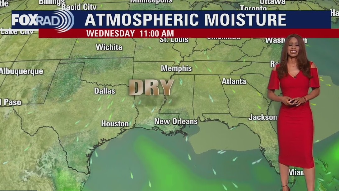
Pleasant Wednesday morning, then mostly sunny and slightly more humid
With fewer clouds overhead today, temperatures got cooler this morning, but should also get warmer this afternoon - mostly near 90. Our pleasant, dry weather pattern won't change very much over the next few days, but humidity could increase by the middle of next week. In the tropics, a wave entering the Caribbean has a good chance of becoming a tropical depression or storm this week. TD #12 is a non-factor in the far eastern Atlantic.
With fewer clouds overhead today, temperatures got cooler this morning, but should also get warmer this afternoon - mostly near 90. Our pleasant, dry weather pattern won't change very much over the next few days, but humidity could increase by the middle of next week. In the tropics, a wave entering the Caribbean has a good chance of becoming a tropical depression or storm this week. TD #12 is a non-factor in the far eastern Atlantic.
Wednesday morning weather forecast
Weather locally still looks awesome with warm afternoons and pleasant mornings. Humidity will be increasing the next few days. Weak cold front drops down late Friday ushering in some drier and slightly cooler air for the weekend. Tropical Depression 12 formed in the far east Caribbean this afternoon but is not expected to be a threat to anyone. Another tropical wave close to the eastern Caribbean may also become a tropical cyclone as it enters the Caribbean over the next few days.
Weather locally still looks awesome with warm afternoons and pleasant mornings. Humidity will be increasing the next few days. Weak cold front drops down late Friday ushering in some drier and slightly cooler air for the weekend. Tropical Depression 12 formed in the far east Caribbean this afternoon but is not expected to be a threat to anyone. Another tropical wave close to the eastern Caribbean may also become a tropical cyclone as it enters the Caribbean over the next few days.