

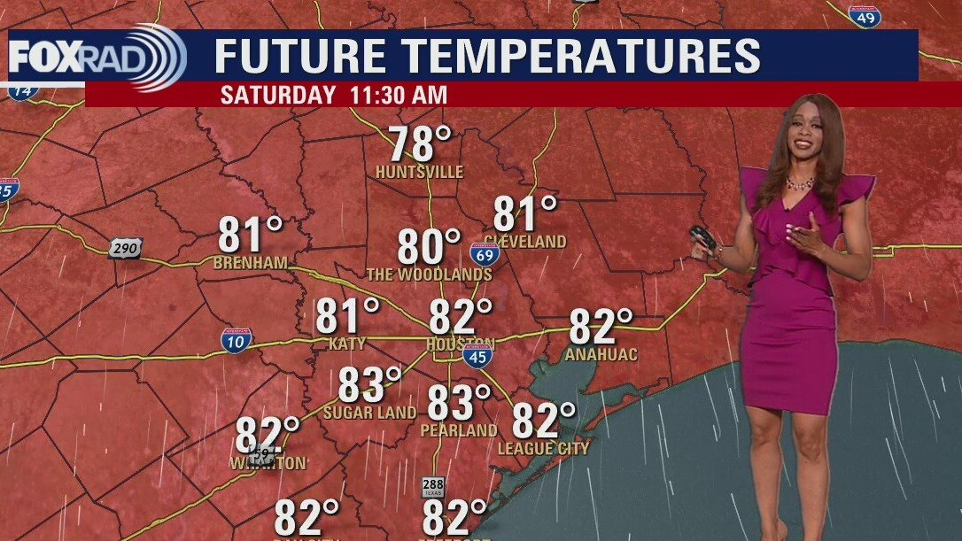
Saturday morning weather forecast
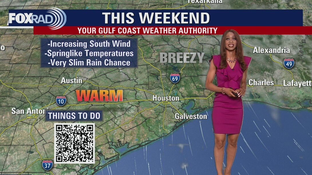
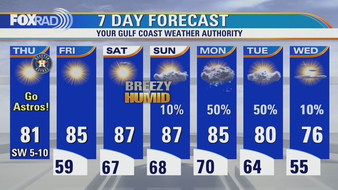
Few changes are in store for Houston weather over the weekend and next week. It will get even warmer with increasing humidity and wind. In fact, winds could gust to near 25 mph this weekend. There's a slim shot for a shower Sunday with better rain and storm chances with a cold front Monday and Tuesday. Also, the remnants of Roslyn early next week could contribute to more moisture over SE Texas and better rain chances.
Few changes are in store for Houston weather over the weekend and next week. It will get even warmer with increasing humidity and wind. In fact, winds could gust to near 25 mph this weekend. There's a slim shot for a shower Sunday with better rain and storm chances with a cold front Monday and Tuesday. Also, the remnants of Roslyn early next week could contribute to more moisture over SE Texas and better rain chances.
Low 80s, some winds this Friday evening with slim rain chances
Few changes are in store for Houston weather over the weekend and next week. It will get even warmer with increasing humidity and wind. In fact winds could gust to near 25 mph this weekend. There's a slim shot for a shower Sunday with better rain and storm chances with a cold front Monday and Tuesday. Also the remnants of Roslyn early next week could contribute to more moisture over SE Texas and better rain chances.
Few changes are in store for Houston weather over the weekend and next week. It will get even warmer with increasing humidity and wind. In fact winds could gust to near 25 mph this weekend. There's a slim shot for a shower Sunday with better rain and storm chances with a cold front Monday and Tuesday. Also the remnants of Roslyn early next week could contribute to more moisture over SE Texas and better rain chances.
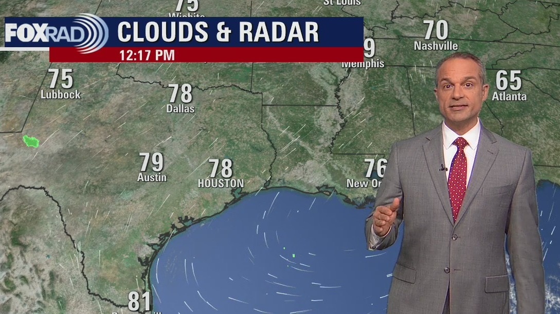
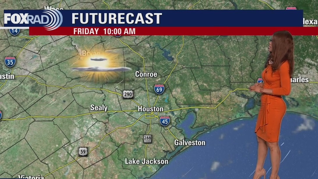
Expect a warm and breezy Friday afternoon in the 80s
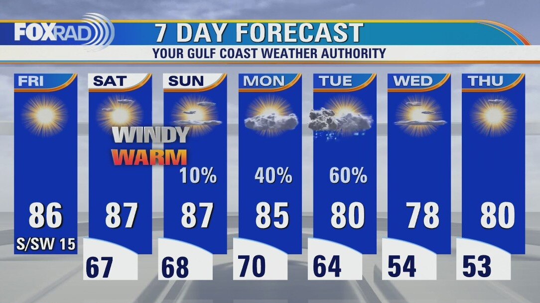
A warming trend along with increasing winds are on the way for today and this weekend. Expect highs in the mid-80s today with mid-to-upper 80s this weekend. I also think we'll have windy weather on Saturday and Sunday which will slowly increase our humidity. A weak cold front early next week should bring a round of showers late Monday into Tuesday.
A warming trend along with increasing winds are on the way for today and this weekend. Expect highs in the mid-80s today with mid-to-upper 80s this weekend. I also think we'll have windy weather on Saturday and Sunday which will slowly increase our humidity. A weak cold front early next week should bring a round of showers late Monday into Tuesday.
Not as chilly Friday morning, then sunny and breezy
A warming trend along with increasing winds are on the way for today and this weekend. Expect highs in the mid 80s today with mid to upper 80s this weekend. I also think we'll have windy weather for Saturday and Sunday which will slowly increase our humidity. A weak cold front early next week should bring a round of showers late Monday into Tuesday.
A warming trend along with increasing winds are on the way for today and this weekend. Expect highs in the mid 80s today with mid to upper 80s this weekend. I also think we'll have windy weather for Saturday and Sunday which will slowly increase our humidity. A weak cold front early next week should bring a round of showers late Monday into Tuesday.
Friday morning weather forecast
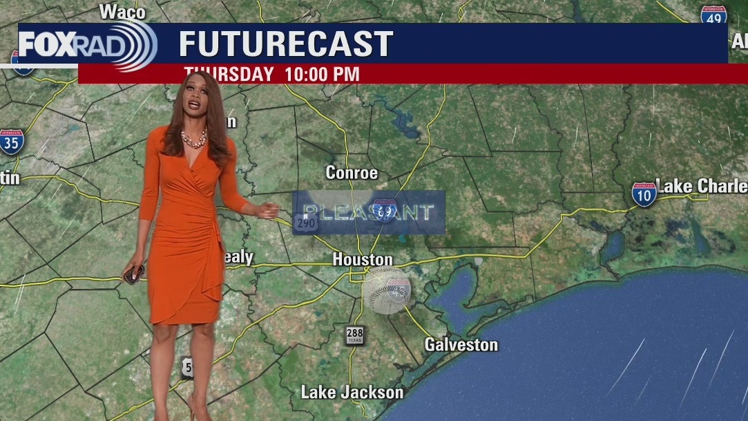
Weather looks great for Astros game tonight with clear skies and pleasant temps dropping from the 70s around the 6:37 first pitch time to the 60s for the majority of the game. Wind will be out of the SW around 5-15 mph. Warmer and more humid weather returns just in time for the weekend with temperatures not far from 90 Saturday and Sunday. Next cold front arrives early next week bringing another round of showers and storms. Tropical Storm Roslyn has formed in the eastern Pacific with 45 mph winds and is expected to become a hurricane this weekend threatening parts of Mexico.
Weather looks great for Astros game tonight with clear skies and pleasant temps dropping from the 70s around the 6:37 first pitch time to the 60s for the majority of the game. Wind will be out of the SW around 5-15 mph. Warmer and more humid weather returns just in time for the weekend with temperatures not far from 90 Saturday and Sunday. Next cold front arrives early next week bringing another round of showers and storms. Tropical Storm Roslyn has formed in the eastern Pacific with 45 mph winds and is expected to become a hurricane this weekend threatening parts of Mexico.
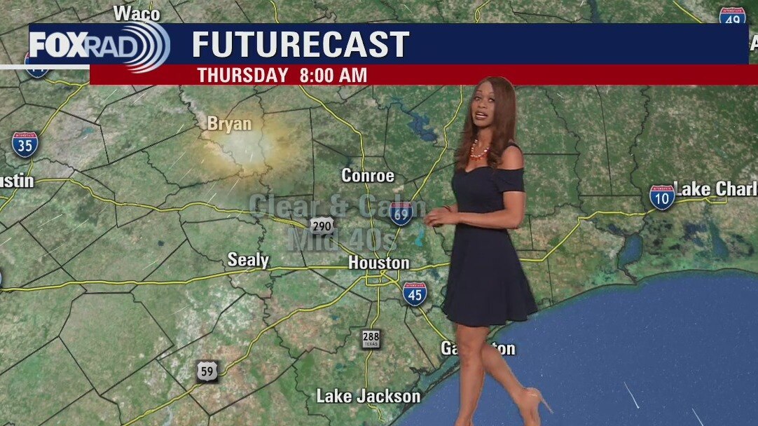
Thursday evening weather forecast
Weather looks great for Astros game tonight with clear skies and pleasant temps dropping from the 70s around the 6:37 first pitch time to the 60s for the majority of the game. Wind will be out of the SW around 5-15 mph. Warmer and more humid weather returns just in time for the weekend with temperatures not far from 90 Saturday and Sunday. Next cold front arrives early next week bringing another round of showers and storms. Tropical Storm Roslyn has formed in the eastern Pacific with 45 mph winds and is expected to become a hurricane this weekend threatening parts of Mexico.
Weather looks great for Astros game tonight with clear skies and pleasant temps dropping from the 70s around the 6:37 first pitch time to the 60s for the majority of the game. Wind will be out of the SW around 5-15 mph. Warmer and more humid weather returns just in time for the weekend with temperatures not far from 90 Saturday and Sunday. Next cold front arrives early next week bringing another round of showers and storms. Tropical Storm Roslyn has formed in the eastern Pacific with 45 mph winds and is expected to become a hurricane this weekend threatening parts of Mexico.
Warm and breezy Thursday afternoon in the mid 70s
Today's weather will be warmer than yesterday and this will mark the beginning of a warming trend taking us through the weekend. Look for highs today near 81, then warmer and breezier weather for Friday and this weekend. Another cold front is on the way early next week and should bring a round of rain either Monday or Tuesday. Go Astros!
Today's weather will be warmer than yesterday and this will mark the beginning of a warming trend taking us through the weekend. Look for highs today near 81, then warmer and breezier weather for Friday and this weekend. Another cold front is on the way early next week and should bring a round of rain either Monday or Tuesday. Go Astros!
Cold Thursday morning, then sunny and warmer
Today's weather will be warmer than yesterday and this will mark the beginning of a warming trend taking us through the weekend. Look for highs today near 81, then warmer and breezier weather for Friday and this weekend. Another cold front is on the way early next week and should bring a round of rain either Monday or Tuesday. Go Astros!
Today's weather will be warmer than yesterday and this will mark the beginning of a warming trend taking us through the weekend. Look for highs today near 81, then warmer and breezier weather for Friday and this weekend. Another cold front is on the way early next week and should bring a round of rain either Monday or Tuesday. Go Astros!
Thursday morning weather forecast
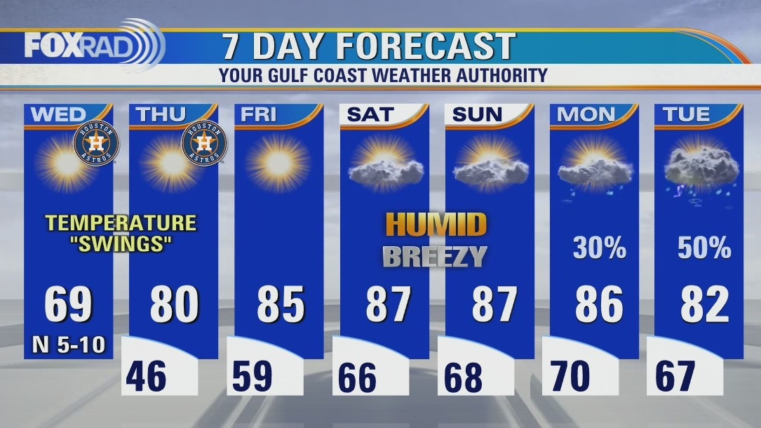
Be ready for another chilly morning in Southeast Texas on Thursday morning. The afternoon will be milder as the atmosphere around Houston starts to transition back to a more humid environment. While the weekend looks warm, it looks like most of the rain will hold off until the start of next week.
Be ready for another chilly morning in Southeast Texas on Thursday morning. The afternoon will be milder as the atmosphere around Houston starts to transition back to a more humid environment. While the weekend looks warm, it looks like most of the rain will hold off until the start of next week.
Cold Wednesday morning, then sunny and very dry
Temperatures early today reached the upper 30s to mid 40s and that was the coolest air since mid-March. Today will be sunny, dry and mild for Astros game 1 of the ALCS and a warmer, dry day for game 2. Warmer air will gradually return by the end of the week and this weekend looks windy, warm and humid. Watch for rain early next week.
Temperatures early today reached the upper 30s to mid 40s and that was the coolest air since mid-March. Today will be sunny, dry and mild for Astros game 1 of the ALCS and a warmer, dry day for game 2. Warmer air will gradually return by the end of the week and this weekend looks windy, warm and humid. Watch for rain early next week.

Wednesday morning weather forecast
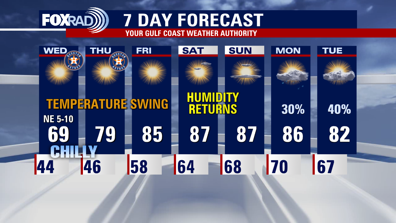
Major temperature swings have been going on over the last few days from record heat Sunday to some of the coolest air since March expected tonight. Look for overnight lows in the 30s in our northern communities tonight and 40s for Houston. Temperatures rebound to near 70 Wednesday and jump back to near 80 by Thursday. Weather should be excellent for Astros Wednesday and Thursday with pleasant and dry weather expected.
Major temperature swings have been going on over the last few days from record heat Sunday to some of the coolest air since March expected tonight. Look for overnight lows in the 30s in our northern communities tonight and 40s for Houston. Temperatures rebound to near 70 Wednesday and jump back to near 80 by Thursday. Weather should be excellent for Astros Wednesday and Thursday with pleasant and dry weather expected.
Tuesday evening weather forecast with Meteorologist Remeisha Shade
Major temperature swings have been going on over the last few days from record heat Sunday to some of the coolest air since March expected tonight. Look for overnight lows in the 30s in our northern communities tonight and 40s for Houston. Temperatures rebound to near 70 Wednesday and jump back to near 80 by Thursday. Weather should be excellent for Astros Wednesday and Thursday with pleasant and dry weather expected.
Major temperature swings have been going on over the last few days from record heat Sunday to some of the coolest air since March expected tonight. Look for overnight lows in the 30s in our northern communities tonight and 40s for Houston. Temperatures rebound to near 70 Wednesday and jump back to near 80 by Thursday. Weather should be excellent for Astros Wednesday and Thursday with pleasant and dry weather expected.
Tuesday afternoon weather forecast with Meteorologist John Dawson
If you've been craving cool air, it's here. We set a record high just two days ago, now were looking for 40s and 50s in the morning this week and highs in the 60s and 70s. Weather looks great for the Astros on Wednesday and Thursday. It does look like humidity will make a comeback this weekend.
If you've been craving cool air, it's here. We set a record high just two days ago, now were looking for 40s and 50s in the morning this week and highs in the 60s and 70s. Weather looks great for the Astros on Wednesday and Thursday. It does look like humidity will make a comeback this weekend.
Chilly and breezy Tuesday morning, then sunny and dry
If you've been craving cool air, it's here. We set a record high just two days ago, now we're looking for 40s and 50s in the morning this week and highs in the 60s and 70s. Weather looks great for the Astros on Wednesday and Thursday. It does look like humidity will make a comeback this weekend.
If you've been craving cool air, it's here. We set a record high just two days ago, now we're looking for 40s and 50s in the morning this week and highs in the 60s and 70s. Weather looks great for the Astros on Wednesday and Thursday. It does look like humidity will make a comeback this weekend.
Tuesday morning weather forecast
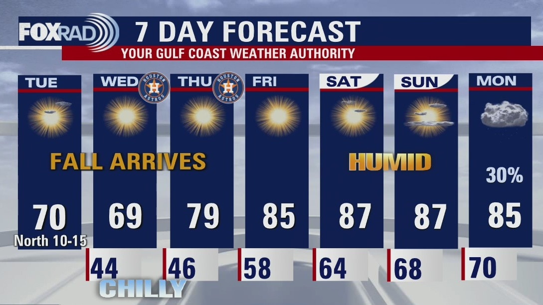
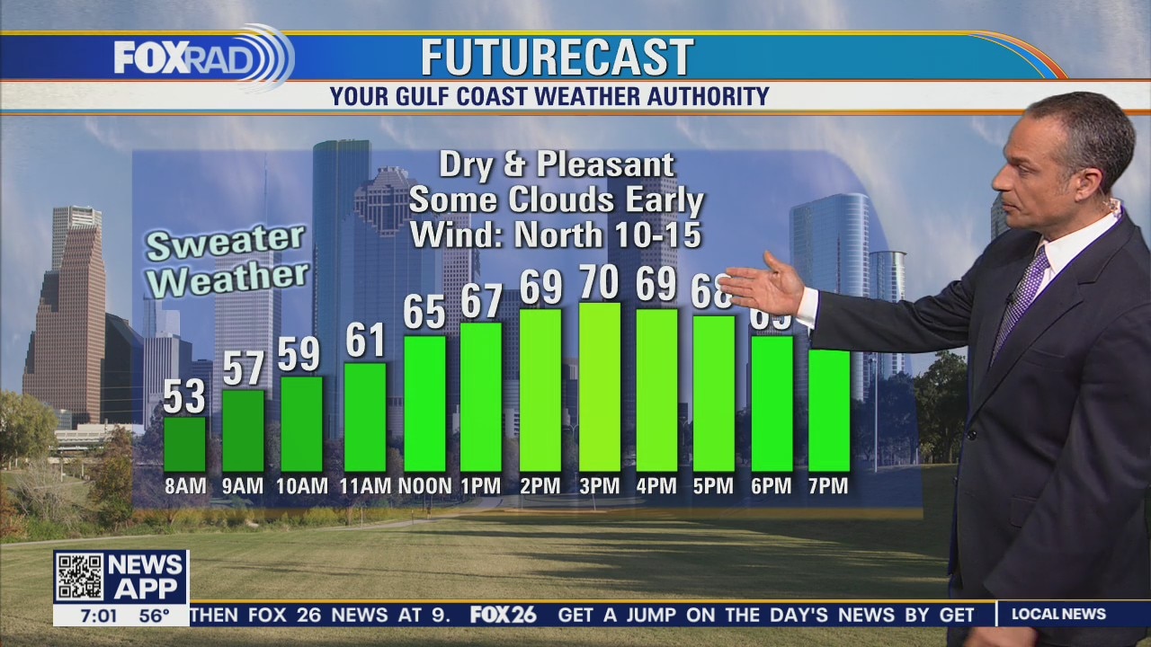
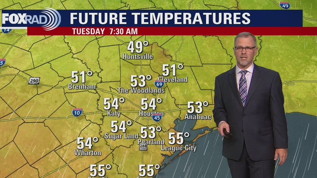
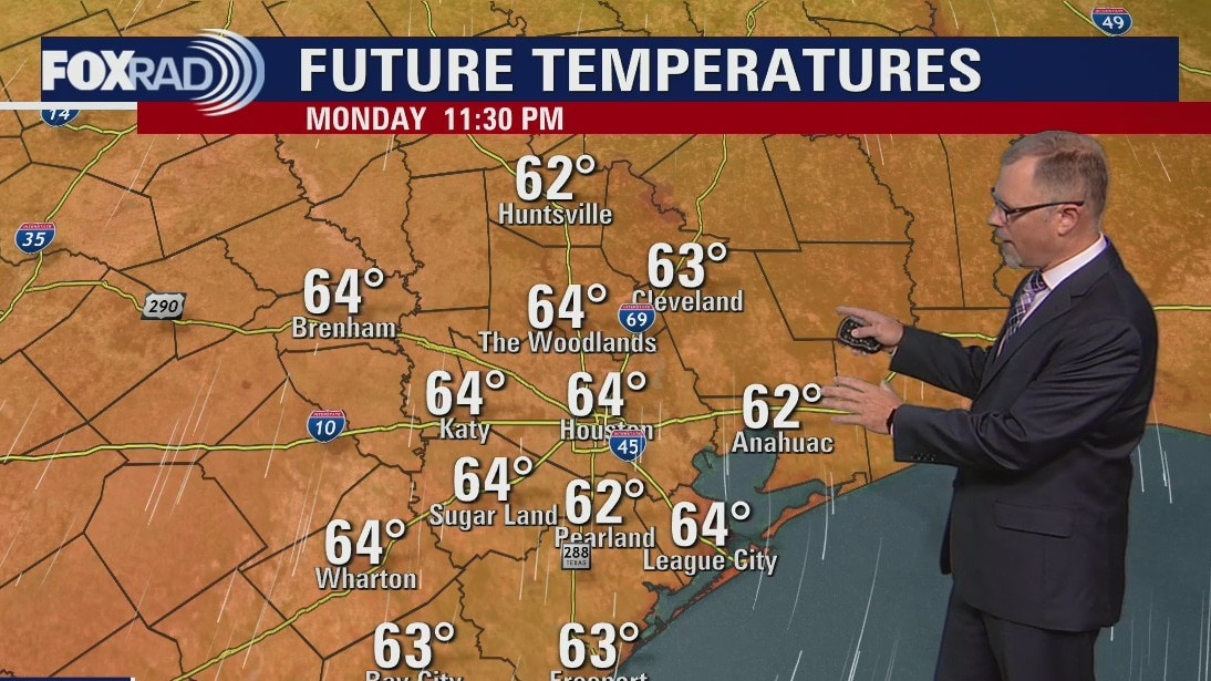
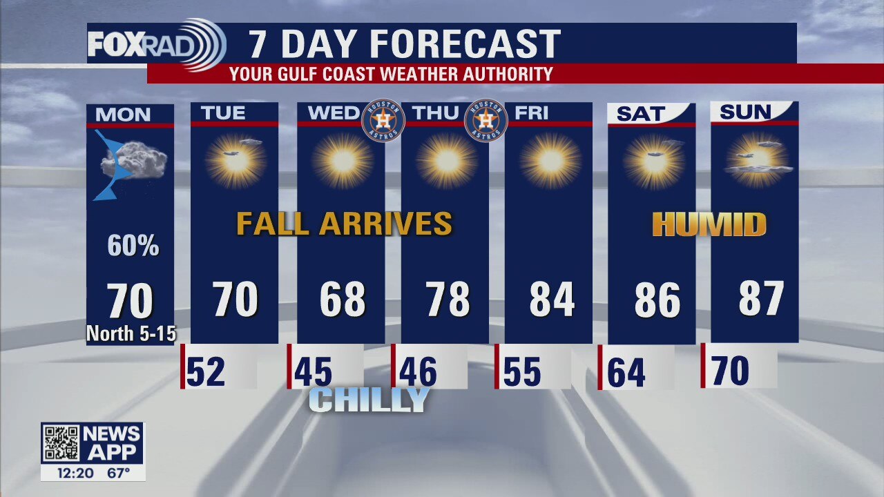
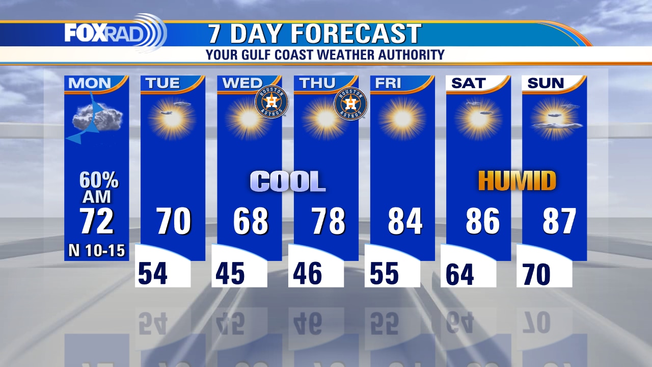
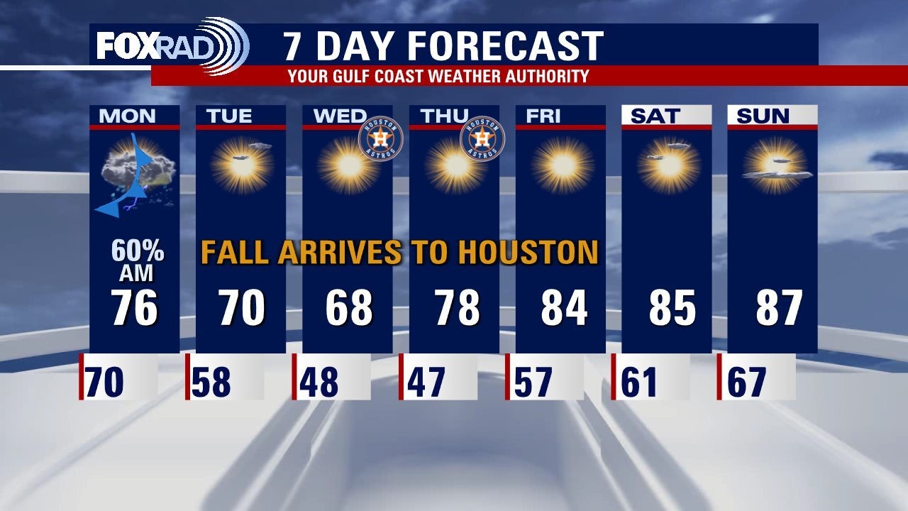
Fall weather arrives to Houston just in time for the American League Championship Series. Go Astros! Skies start to clear on Tuesday as the winds from the north start to push in cooler air. Expect some down right chilly mornings on Wednesday and Thursday with most of Southeast Texas in the 40s. The winds shift around to the southeast at the end of the week and that will lead to a milder weekend with temperatures returning to normal for this time of October.
Fall weather arrives to Houston just in time for the American League Championship Series. Go Astros! Skies start to clear on Tuesday as the winds from the north start to push in cooler air. Expect some down right chilly mornings on Wednesday and Thursday with most of Southeast Texas in the 40s. The winds shift around to the southeast at the end of the week and that will lead to a milder weekend with temperatures returning to normal for this time of October.
Monday evening weather forecast
Fall weather arrives to Houston just in time for the American League Championship Series. Go Astros! Skies start to clear on Tuesday as the winds from the north start to push in cooler air. Expect some down right chilly mornings on Wednesday and Thursday with most of Southeast Texas in the 40s. The winds shift around to the southeast at the end of the week and that will lead to a milder weekend with temperatures returning to normal for this time of October.
Fall weather arrives to Houston just in time for the American League Championship Series. Go Astros! Skies start to clear on Tuesday as the winds from the north start to push in cooler air. Expect some down right chilly mornings on Wednesday and Thursday with most of Southeast Texas in the 40s. The winds shift around to the southeast at the end of the week and that will lead to a milder weekend with temperatures returning to normal for this time of October.
Monday afternoon weather forecast with Chief Meteorologist Mike Iscovitz
After hitting a record high of 92? on Sunday, a cold front today will bring rain followed by cooler north breezes. Afternoon temps will run around 20? cool than yesterday. The next few days will really feel like fall with highs near 70 and lows in the 40s and 50s. Some areas could feel the lowest temperatures since March!
After hitting a record high of 92? on Sunday, a cold front today will bring rain followed by cooler north breezes. Afternoon temps will run around 20? cool than yesterday. The next few days will really feel like fall with highs near 70 and lows in the 40s and 50s. Some areas could feel the lowest temperatures since March!
Monday morning weather forecast with Chief Meteorologist Mike Iscovitz
After hitting a record high of 92? on Sunday, a cold front today will bring rain followed by cooler north breezes. Afternoon temps will run around 20? cool than yesterday. The next few days will really feel like fall with highs near 70 and lows in the 40s and 50s. Some areas could feel the lowest temperatures since March!
After hitting a record high of 92? on Sunday, a cold front today will bring rain followed by cooler north breezes. Afternoon temps will run around 20? cool than yesterday. The next few days will really feel like fall with highs near 70 and lows in the 40s and 50s. Some areas could feel the lowest temperatures since March!
Sunday night leading into Monday morning weather forecast
The October heat has come to an end for Houston, well at least the 90 degree days have come to an end. Look for a rainy and overcast Monday as this season's first strong cold front crawls through Southeast Texas. Highest chances of showers/storms will be during the morning commute. Skies start to clear on Tuesday morning and the cooler air really starts to move in. The southeast winds return for the end of the week bringing the 80s back into the forecast for next weekend.
The October heat has come to an end for Houston, well at least the 90 degree days have come to an end. Look for a rainy and overcast Monday as this season's first strong cold front crawls through Southeast Texas. Highest chances of showers/storms will be during the morning commute. Skies start to clear on Tuesday morning and the cooler air really starts to move in. The southeast winds return for the end of the week bringing the 80s back into the forecast for next weekend.
Sunday Morning Forecast with Meteorologist Lena Maria Arango
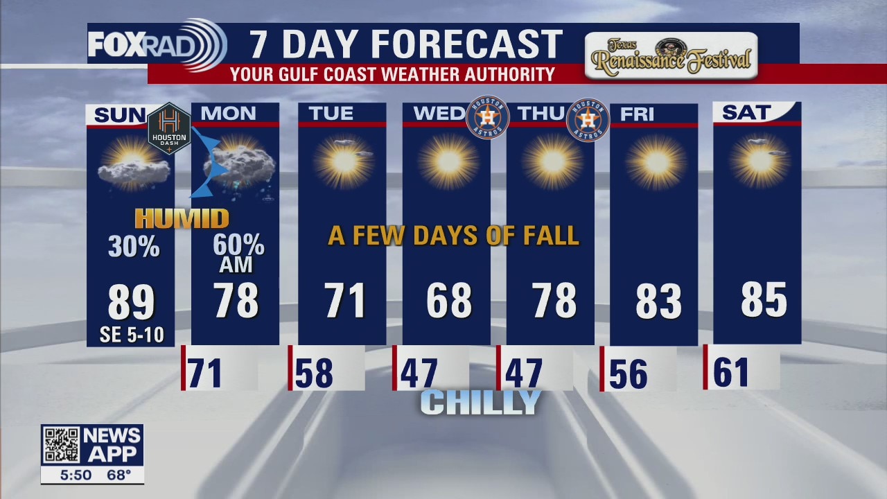
Sunday will be more showery in nature, mainly in the afternoon and evening. Monday's rain peaks in the morning, and then slowly tapers throughout the day. From there, north breezes usher in a solid dose of cooler air midweek. We may actually get to have a few roof open games for once! Enjoy it while it lasts, because high pressure exits East and onshore flow quickly returns... warming us back into the 80s by the weekend.
Sunday will be more showery in nature, mainly in the afternoon and evening. Monday's rain peaks in the morning, and then slowly tapers throughout the day. From there, north breezes usher in a solid dose of cooler air midweek. We may actually get to have a few roof open games for once! Enjoy it while it lasts, because high pressure exits East and onshore flow quickly returns... warming us back into the 80s by the weekend.