

Friday weather forecast
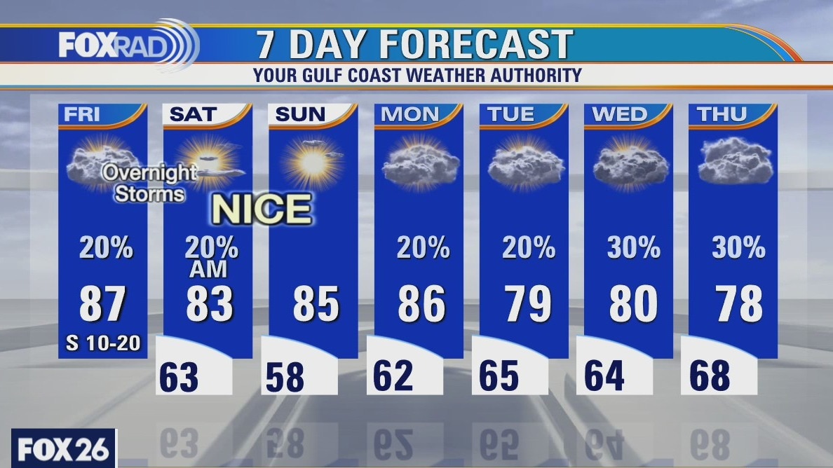
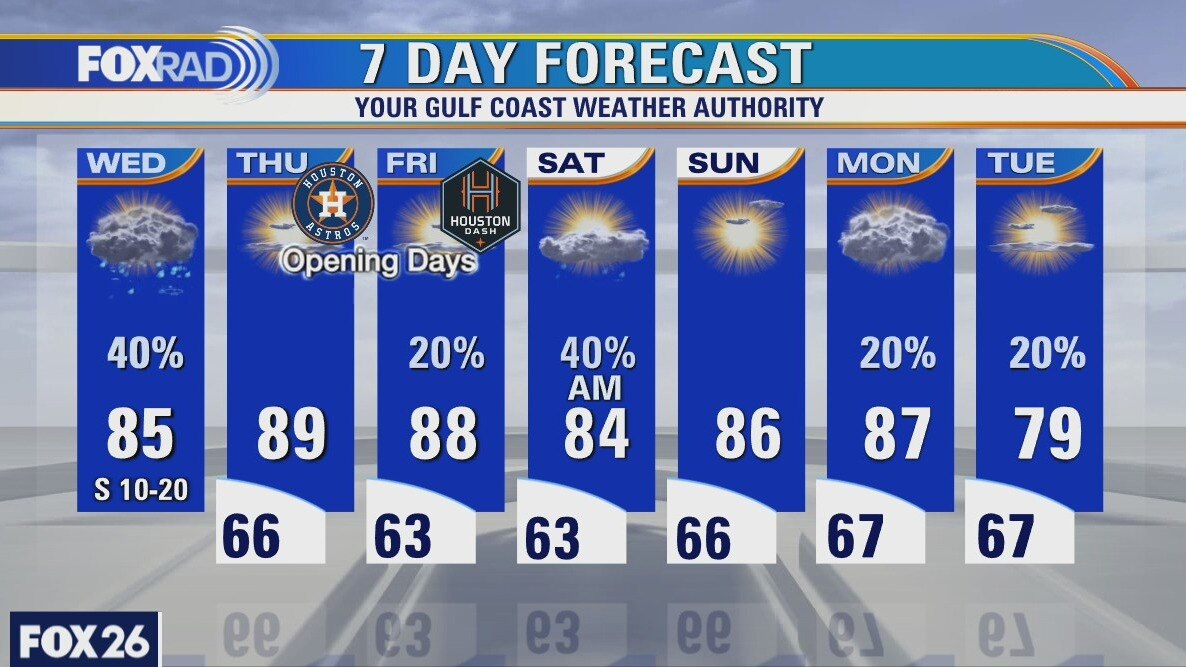
We'll have a few ups and downs over the next few days, but the good news is that the weekend looks very nice. Today, expect breezy, warm and cloudy conditions with isolated showers. Tonight through early tomorrow morning, a cold front will bring the chance for a few strong storms. That system will be followed by lower humidity and sunshine for the weekend with lows in the 50s and highs in the 80s.
We'll have a few ups and downs over the next few days, but the good news is that the weekend looks very nice. Today, expect breezy, warm and cloudy conditions with isolated showers. Tonight through early tomorrow morning, a cold front will bring the chance for a few strong storms. That system will be followed by lower humidity and sunshine for the weekend with lows in the 50s and highs in the 80s.
Friday morning weather forecast
Friday will be very warm during the day with highs in the upper 80s. Look for showers into the evening with larger storms possible mainly north of the Houston area. The weekend looks pretty nice and next week will be warm, humid and with a daily chance for a little rain.
Friday will be very warm during the day with highs in the upper 80s. Look for showers into the evening with larger storms possible mainly north of the Houston area. The weekend looks pretty nice and next week will be warm, humid and with a daily chance for a little rain.
Thursday Evening Weather Forecast
Friday will be very warm during the day with highs in the upper 80s. Look for showers into the evening with larger storms possible mainly north of the Houston area. The weekend looks pretty nice and next week will be warm, humid and with a daily chance for a little rain.
Friday will be very warm during the day with highs in the upper 80s. Look for showers into the evening with larger storms possible mainly north of the Houston area. The weekend looks pretty nice and next week will be warm, humid and with a daily chance for a little rain.
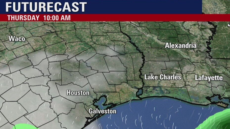
Thursday weather forecast
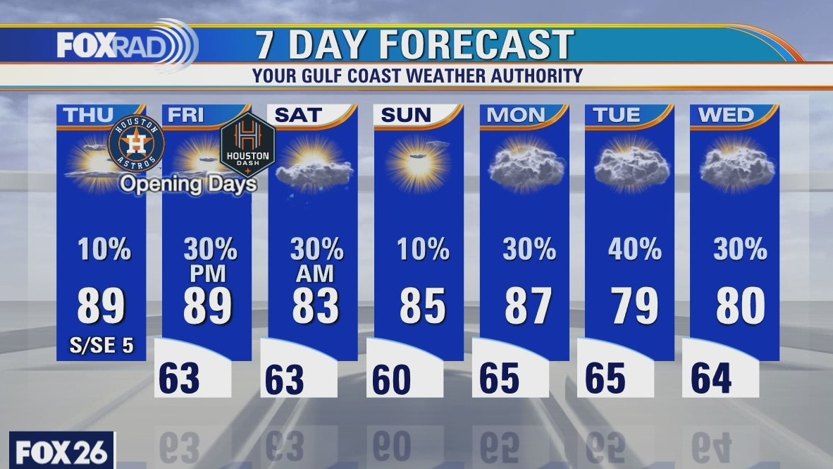
Today is looking like the warmest day of 2021 so far with highs in the mid to upper 80s and tomorrow looks very warm as well. We will be watching for a few strong storms, mostly north of Houston, Friday night into early Saturday. Beyond that, the weekend should be very nice.
Today is looking like the warmest day of 2021 so far with highs in the mid to upper 80s and tomorrow looks very warm as well. We will be watching for a few strong storms, mostly north of Houston, Friday night into early Saturday. Beyond that, the weekend should be very nice.
Thursday morning weather forecast
Showers will move through the area tonight and a few storms in our eastern counties. A better chance for rain comes Friday night and there could more storms across the region. The computer models are not in good agreement about it yet, and we will know a lot more by early Thursday.
Showers will move through the area tonight and a few storms in our eastern counties. A better chance for rain comes Friday night and there could more storms across the region. The computer models are not in good agreement about it yet, and we will know a lot more by early Thursday.
Wednesday Evening Weather Forecast
A line of thundershowers will move across portions of SE Texas and the Houston area this evening. There are no watches or warnings for us, but severe storms are just to the east. Friday may bring a better chance for more storms and rain.
A line of thundershowers will move across portions of SE Texas and the Houston area this evening. There are no watches or warnings for us, but severe storms are just to the east. Friday may bring a better chance for more storms and rain.
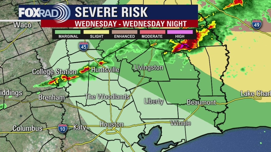
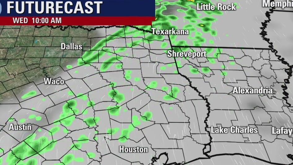
Wednesday weather forecast
Wednesday will be another breezy and warm day across Southeast Texas. There will be some scattered showers and a few isolated storms late in the afternoon. Thursday and Friday will be very warm and the next storm system will be in the Houston area Friday evening.
Wednesday will be another breezy and warm day across Southeast Texas. There will be some scattered showers and a few isolated storms late in the afternoon. Thursday and Friday will be very warm and the next storm system will be in the Houston area Friday evening.
Wednesday morning weather forecast
Scattered showers and a few t-storms are expected mainly in the afternoon and early evening Wed. Severe weather is likely east of SE Texas, but does not seem to be a big problem for the Houston area. Daily temps look warm and above average into the weekend. Showers will be possible again late Friday night or early Saturday.
Scattered showers and a few t-storms are expected mainly in the afternoon and early evening Wed. Severe weather is likely east of SE Texas, but does not seem to be a big problem for the Houston area. Daily temps look warm and above average into the weekend. Showers will be possible again late Friday night or early Saturday.

Tuesday evening weather forecast
Scattered showers and a few t-storms are expected mainly in the afternoon and early evening Wed. Severe weather is likely east of SE Texas, but does not seem to be a big problem for the Houston area. Daily temps look warm and above average into the weekend. Showers will be possible again late Friday night or early Saturday.
Scattered showers and a few t-storms are expected mainly in the afternoon and early evening Wed. Severe weather is likely east of SE Texas, but does not seem to be a big problem for the Houston area. Daily temps look warm and above average into the weekend. Showers will be possible again late Friday night or early Saturday.
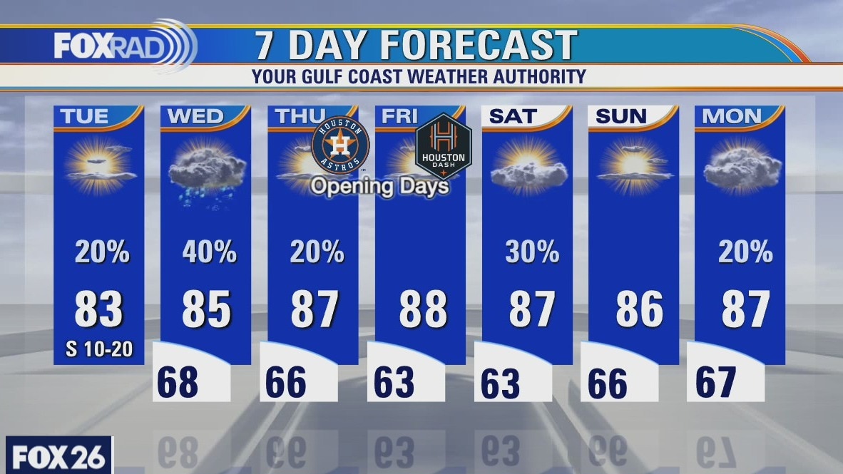
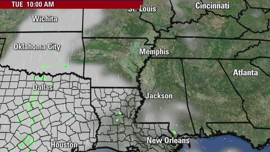
Tuesday weather forecast
A mild morning will lead to a warm afternoon with temperatures in the lower 80s. Look for another breezy day with a few showers. Isolated storms possible late tomorrow as a weak front nears Southeast Texas. Look for warmer temperatures at the end of the week with afternoon highs in the upper 80s on Thursday and Friday.
A mild morning will lead to a warm afternoon with temperatures in the lower 80s. Look for another breezy day with a few showers. Isolated storms possible late tomorrow as a weak front nears Southeast Texas. Look for warmer temperatures at the end of the week with afternoon highs in the upper 80s on Thursday and Friday.
Tuesday morning weather forecast
The weather pattern this week looks rather steady with warm afternoons and mild mornings. Highs will be in the 80s and lows in the 60s. Look for fog early in the mornings and a daily chance for brief showers. Wed. could bring a little thunder to the Houston area, but any severe storms look to be more east and north of our area.
The weather pattern this week looks rather steady with warm afternoons and mild mornings. Highs will be in the 80s and lows in the 60s. Look for fog early in the mornings and a daily chance for brief showers. Wed. could bring a little thunder to the Houston area, but any severe storms look to be more east and north of our area.
Monday evening weather forecast
The weather pattern this week looks rather steady with warm afternoons and mild mornings. Highs will be in the 80s and lows in the 60s. Look for fog early in the mornings and a daily chance for brief showers. Wed. could bring a little thunder to the Houston area, but any severe storms look to be more east and north of our area.
The weather pattern this week looks rather steady with warm afternoons and mild mornings. Highs will be in the 80s and lows in the 60s. Look for fog early in the mornings and a daily chance for brief showers. Wed. could bring a little thunder to the Houston area, but any severe storms look to be more east and north of our area.
Morning Weather Forecast
Our cool mornings are disappearing and warm afternoons are on the way. We could also see a few April Showers this week. No storms expected but Houston is really starting to get dry, we could use some rain soon.
Our cool mornings are disappearing and warm afternoons are on the way. We could also see a few April Showers this week. No storms expected but Houston is really starting to get dry, we could use some rain soon.
Houston-area weather forecast: April 4th
We?re starting off cool on this Easter Sunday, but it appears that we will be warmer by the afternoon as we could see a few more peeks of sun today. Highs should reach the mid 70s, but an isolated shower will be possible mainly after noon. Temperatures will really begin to warm up as we had toward the middle part of the week with highs by Thursday possibly reaching the upper 80s. Rain chances will remain slim throughout the week.
We?re starting off cool on this Easter Sunday, but it appears that we will be warmer by the afternoon as we could see a few more peeks of sun today. Highs should reach the mid 70s, but an isolated shower will be possible mainly after noon. Temperatures will really begin to warm up as we had toward the middle part of the week with highs by Thursday possibly reaching the upper 80s. Rain chances will remain slim throughout the week.

Sunday Morning Weather Forecast
Are you one that enjoys temperatures in the 90s? Well, we are headed that direction! This week will bring a couple opportunities for some April Showers but fortunately no Spring Storms expected.
Are you one that enjoys temperatures in the 90s? Well, we are headed that direction! This week will bring a couple opportunities for some April Showers but fortunately no Spring Storms expected.
Houston-area weather forecast: April 3rd
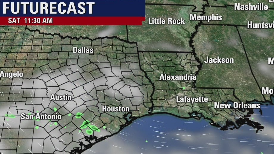
A few showers...even a stray storm will be possible on Saturday as Sunday as we deal with an upper level disturbance that will move through the area. Most of our weekend will be dry, but some may encounter these showers. Temperatures will start off cooler each day, but we?ll warm into the upper 60s and low 70s. The real warming occurs next week as we kick off our first full week of April. Some of the warmest air of the year is expected as we will likely climb into the upper 80s by Thursday and Friday. Rain chances will remain between 10% and 20% throughout the week.
A few showers...even a stray storm will be possible on Saturday as Sunday as we deal with an upper level disturbance that will move through the area. Most of our weekend will be dry, but some may encounter these showers. Temperatures will start off cooler each day, but we?ll warm into the upper 60s and low 70s. The real warming occurs next week as we kick off our first full week of April. Some of the warmest air of the year is expected as we will likely climb into the upper 80s by Thursday and Friday. Rain chances will remain between 10% and 20% throughout the week.
Saturday morning weather forecast
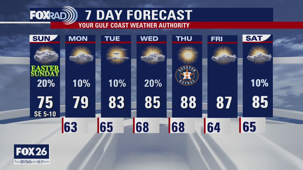
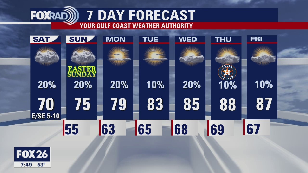
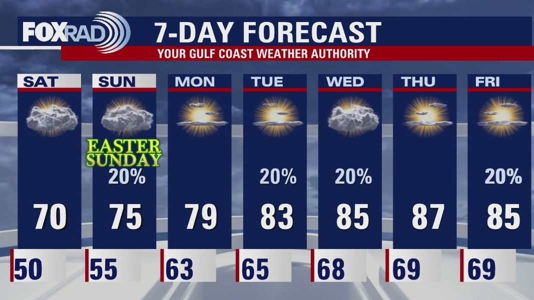
The humidity will return over the weekend and temps will start to warm up some. There is a 20% risk for light showers or mist on Easter Sunday, but it will not be overly wet. The coming week looks warmer with highs in the 80s. There will continue to be a slight chance for rain, but nothing looks very impressive or too organized.
The humidity will return over the weekend and temps will start to warm up some. There is a 20% risk for light showers or mist on Easter Sunday, but it will not be overly wet. The coming week looks warmer with highs in the 80s. There will continue to be a slight chance for rain, but nothing looks very impressive or too organized.
Friday evening weather forecast
The humidity will return over the weekend and temps will start to warm up some. There is a 20% risk for light showers or mist on Easter Sunday, but it will not be overly wet. The coming week looks warmer with highs in the 80s. There will continue to be a slight chance for rain, but nothing looks very impressive or too organized.
The humidity will return over the weekend and temps will start to warm up some. There is a 20% risk for light showers or mist on Easter Sunday, but it will not be overly wet. The coming week looks warmer with highs in the 80s. There will continue to be a slight chance for rain, but nothing looks very impressive or too organized.
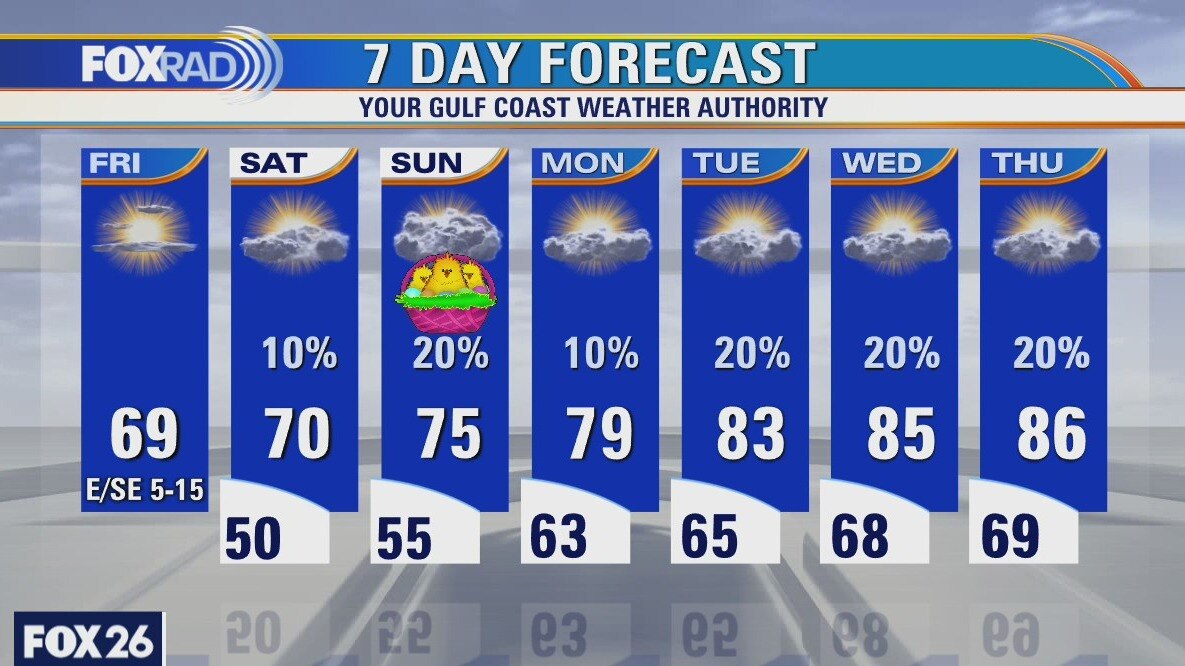
Friday weather forecast
Lows this morning were likely the coldest we'll have for many months (low 40s) as we will begin a warming trend beginning on Easter Sunday afternoon. Look for sunshine with high clouds today and highs in the upper 60s. This weekend looks breezy and slightly cool with a few isolated drizzles. Next week, mid to upper 80s are possible.
Lows this morning were likely the coldest we'll have for many months (low 40s) as we will begin a warming trend beginning on Easter Sunday afternoon. Look for sunshine with high clouds today and highs in the upper 60s. This weekend looks breezy and slightly cool with a few isolated drizzles. Next week, mid to upper 80s are possible.
Friday morning weather forecast
Conditions will cool this evening and the winds will turn from the north and be breezy. It will be chilly over the next couple of mornings with lows mostly dipping into the 40s. There will be plenty of sunshine during the day, but highs will only reach the upper 60s and low 70s until Easter Sunday. A few light showers are possible on Sunday, but nothing too soggy for Easter Egg hunts.
Conditions will cool this evening and the winds will turn from the north and be breezy. It will be chilly over the next couple of mornings with lows mostly dipping into the 40s. There will be plenty of sunshine during the day, but highs will only reach the upper 60s and low 70s until Easter Sunday. A few light showers are possible on Sunday, but nothing too soggy for Easter Egg hunts.