


Houston weather: Isolated storms Thursday afternoon
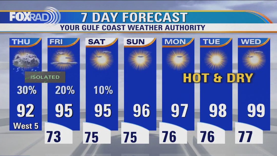
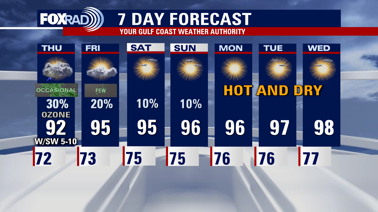
We are looking for more afternoon storms in the Houston area today. Less expected for Friday with more heat building in this week. We may need a heat advisory next week as temperatures will get close to triple digits. Ozone Action Day again for today.
We are looking for more afternoon storms in the Houston area today. Less expected for Friday with more heat building in this week. We may need a heat advisory next week as temperatures will get close to triple digits. Ozone Action Day again for today.

Houston-weather: Severe weather possible on Thursday
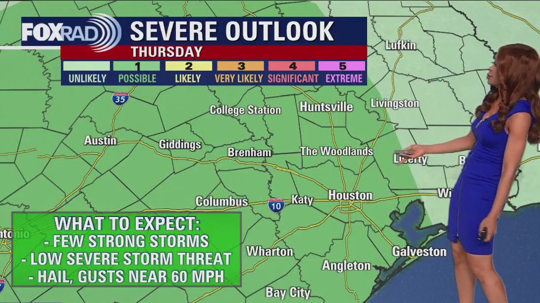
Spotty storms are once again possible Thursday afternoon and evening with a few heavy downpours, frequent lightning and some strong wind gusts. There's even a low risk for an isolated severe storm with gusts near 60 mph and hail near 1". But after Thursday, our rain chances start to wind down and temperatures soar. Look for a heat dome to build in for much of next week with hot and dry weather as temperatures soar to near 100 by the middle of next week.
Spotty storms are once again possible Thursday afternoon and evening with a few heavy downpours, frequent lightning and some strong wind gusts. There's even a low risk for an isolated severe storm with gusts near 60 mph and hail near 1". But after Thursday, our rain chances start to wind down and temperatures soar. Look for a heat dome to build in for much of next week with hot and dry weather as temperatures soar to near 100 by the middle of next week.

Houston Weather: Lower floodthreat but isolated street flooding is possible due to heavy downpours
A few showers and storms are still possible through early tonight. The flood threat is much lower but I can't rule out a heavy downpour causing some isolated street flooding. Otherwise, look for us to dry out for much of the night with a bit of patchy fog possible early Thursday. Spotty storms are once again possible Thursday afternoon and evening with a few heavy downpours, frequent lightning, and some strong wind gusts. There's even a low risk for an isolated severe storm with gusts near 60 mph and hail near 1". But after Thursday, our rain chances start to wind down and temperatures soar. Look for a heat dome to build in for much of next week with hot and dry weather as temperatures soar to near 100 by the middle of next week.
A few showers and storms are still possible through early tonight. The flood threat is much lower but I can't rule out a heavy downpour causing some isolated street flooding. Otherwise, look for us to dry out for much of the night with a bit of patchy fog possible early Thursday. Spotty storms are once again possible Thursday afternoon and evening with a few heavy downpours, frequent lightning, and some strong wind gusts. There's even a low risk for an isolated severe storm with gusts near 60 mph and hail near 1". But after Thursday, our rain chances start to wind down and temperatures soar. Look for a heat dome to build in for much of next week with hot and dry weather as temperatures soar to near 100 by the middle of next week.


Houston weather: Mostly sunny, hot Wednesday afternoon in the 80s
Be on the lookout for isolated to scattered downpours and storms in the afternoons today, and tomorrow. As we head into the weekend, rain chances drop but temperatures on the thermometer will begin to spike. Next week, a heat dome will build leading to several hot and dry days. "Feels Like" values will likely approach thresholds to prompt our first heat advisories of the season. Nothing is being monitored for development at this time in the tropical Atlantic.
Be on the lookout for isolated to scattered downpours and storms in the afternoons today, and tomorrow. As we head into the weekend, rain chances drop but temperatures on the thermometer will begin to spike. Next week, a heat dome will build leading to several hot and dry days. "Feels Like" values will likely approach thresholds to prompt our first heat advisories of the season. Nothing is being monitored for development at this time in the tropical Atlantic.


Houston weather: Triple digital temperatures returning soon
Live & breaking news for the entire Houston area.
Live & breaking news for the entire Houston area.


Houston weather: Isolated Wednesday afternoon showers/storms
We've got a few more days with decent shots at isolated afternoon downpours today and tomorrow. Temperatures will begin to spike next week as a heat dome builds and we turn the page back to a hot and dry pattern. We'll likely see our first heat advisories and triple digit days of the season soon, so brush up on heat safety for yourself, pets and little ones. Tropics are quiet with only one area being monitored way out in the Atlantic with only a 10% shot of development and it won't be coming anywhere near us.
We've got a few more days with decent shots at isolated afternoon downpours today and tomorrow. Temperatures will begin to spike next week as a heat dome builds and we turn the page back to a hot and dry pattern. We'll likely see our first heat advisories and triple digit days of the season soon, so brush up on heat safety for yourself, pets and little ones. Tropics are quiet with only one area being monitored way out in the Atlantic with only a 10% shot of development and it won't be coming anywhere near us.


Houston weather: Spotty storms possible again on Wednesday
Spotty storms are expected again Wednesday afternoon with a few more storms Thursday PM. For the weekend and next week, the pattern is expected to shift to a hotter and drier one with temperatures soaring well into the 90s and very little rain. Humidity will be high as well next week which could to some triple digit heat index values. Summer is just a few weeks away and we will start to feel more of that summer sizzle soon! Make sure to download the FOX 26 WX App to keep track of all of the latest weather changes headed our way!
Spotty storms are expected again Wednesday afternoon with a few more storms Thursday PM. For the weekend and next week, the pattern is expected to shift to a hotter and drier one with temperatures soaring well into the 90s and very little rain. Humidity will be high as well next week which could to some triple digit heat index values. Summer is just a few weeks away and we will start to feel more of that summer sizzle soon! Make sure to download the FOX 26 WX App to keep track of all of the latest weather changes headed our way!


Houston Weather: Storms to wind down but spotty showers expected to come back over the next couple days
Scattered storms that have developed this afternoon will be capable of very heavy rain that could lead to isolated street flooding. Look for these showers and storms to wind down around sunset. Spotty storms are expected again Wednesday afternoon with a few more storms Thursday PM. For the weekend and next week, the pattern is expected to shift to a hotter and drier one with temperatures soaring well into the 90s and very little rain. Humidity will be high as well next week which could to some triple-digit heat index values. Summer is just a few weeks away and we will start to feel more of that summer sizzle soon! Make sure to download the FOX 26 WX App to keep track of all of the latest weather changes headed our way!
Scattered storms that have developed this afternoon will be capable of very heavy rain that could lead to isolated street flooding. Look for these showers and storms to wind down around sunset. Spotty storms are expected again Wednesday afternoon with a few more storms Thursday PM. For the weekend and next week, the pattern is expected to shift to a hotter and drier one with temperatures soaring well into the 90s and very little rain. Humidity will be high as well next week which could to some triple-digit heat index values. Summer is just a few weeks away and we will start to feel more of that summer sizzle soon! Make sure to download the FOX 26 WX App to keep track of all of the latest weather changes headed our way!


Strong storms to return to Houston-area, what you need to know
Strong storms return to the Houston area again this afternoon. FOX 26 Meteorologist Remeisha Shade has the latest on the heavy downpours across the area.
Strong storms return to the Houston area again this afternoon. FOX 26 Meteorologist Remeisha Shade has the latest on the heavy downpours across the area.


Houston weather: Scattered storms Tuesday afternoon
Slightly cooler this morning with patchy fog, then partly cloudy and warm with scattered afternoon storms.
Slightly cooler this morning with patchy fog, then partly cloudy and warm with scattered afternoon storms.


Houston weather: Storms possible, heat on the way this weekend
Scattered storms are possible during the afternoon and evening. Overall, the trend will be for less storms late in the week and more heat. We'll go from highs in the upper 80s Tuesday to high temperatures in the middle 90s by Friday! Make sure to download our Fox 26 Weather App to keep track of the latest weather happening in your area!
Scattered storms are possible during the afternoon and evening. Overall, the trend will be for less storms late in the week and more heat. We'll go from highs in the upper 80s Tuesday to high temperatures in the middle 90s by Friday! Make sure to download our Fox 26 Weather App to keep track of the latest weather happening in your area!


Houston Weather: Heavy downpours tonight with possible street flooding in some areas
Scattered storms with some heavy downpours are a good bet through early tonight. That's when much of this activity should start to fade. The damaging wind threat is low but watches out for some street flooding in areas that pick up heavy rain in a short period of time. We repeat this pattern again for Tuesday with scattered storms during the afternoon and evening. Overall, the trend will be for fewer storms late in the week and more heat. We'll go from highs in the upper 80s Tuesday to high temperatures in the middle 90s by Friday! Make sure to download our Fox 26 Weather App to keep track of the latest weather happening in your area!
Scattered storms with some heavy downpours are a good bet through early tonight. That's when much of this activity should start to fade. The damaging wind threat is low but watches out for some street flooding in areas that pick up heavy rain in a short period of time. We repeat this pattern again for Tuesday with scattered storms during the afternoon and evening. Overall, the trend will be for fewer storms late in the week and more heat. We'll go from highs in the upper 80s Tuesday to high temperatures in the middle 90s by Friday! Make sure to download our Fox 26 Weather App to keep track of the latest weather happening in your area!


Houston Weather: More rain expected until hot and humid weekend
Get ready for a round of heavy storms this afternoon. The exact locations will be a roll of the dice, but 2-3" of rain could fall in isolated spots, so street flooding will be possible in spots this afternoon or early evening. For the rest of the week, expect a warming trend with hot and humid weather by late in the week.
Get ready for a round of heavy storms this afternoon. The exact locations will be a roll of the dice, but 2-3" of rain could fall in isolated spots, so street flooding will be possible in spots this afternoon or early evening. For the rest of the week, expect a warming trend with hot and humid weather by late in the week.


Houston weather: Some Monday morning showers, storms likely by midday and afternoon
Get ready for a round of heavy storms this afternoon. The exact locations will be a roll of the dice, but 2-3" of rain could fall in isolated spots, so street flooding will be possible in spots this afternoon or early evening. For the rest of the week, expect a warming trend with hot and humid weather by late in the week.
Get ready for a round of heavy storms this afternoon. The exact locations will be a roll of the dice, but 2-3" of rain could fall in isolated spots, so street flooding will be possible in spots this afternoon or early evening. For the rest of the week, expect a warming trend with hot and humid weather by late in the week.


Houston weather: Storms expected next few days, heavy rainfall possible through Tuesday
Southeast Texas can expect scattered showers and storms over the next few days with temperatures slightly below normal. Locally heavy rainfall is possible at times through Tuesday. As we move into next weekend the general pattern will change to less rain and more heat.
Southeast Texas can expect scattered showers and storms over the next few days with temperatures slightly below normal. Locally heavy rainfall is possible at times through Tuesday. As we move into next weekend the general pattern will change to less rain and more heat.


Houston weather: Partly cloudy Sunday evening in 80s, showers expected next few days
Southeast Texas can expect scattered showers and storms over the next few days with temperatures slightly below normal. Locally heavy rainfall is possible at times through Tuesday. As we move into next weekend the general pattern will change to less rain and more heat.
Southeast Texas can expect scattered showers and storms over the next few days with temperatures slightly below normal. Locally heavy rainfall is possible at times through Tuesday. As we move into next weekend the general pattern will change to less rain and more heat.


Houston Weather: Heavy rainfall, temperatures in 80s over the next few days
Scattered storms will be in the mix over the next few days with temps kept at bay mostly in the 80s. A cluster of storms that formed overnight has lowered our rain chances for later today. We have been dropped from the excessive rainfall outlook, and are also not expecting severe weather with any of these rounds of storms. But, a few feisty ones still may find themselves in the mix. In general, as we head through the week rain chances go down and temps go up. Arlene has dissipated, and nothing else is being monitored for development at this time.
Scattered storms will be in the mix over the next few days with temps kept at bay mostly in the 80s. A cluster of storms that formed overnight has lowered our rain chances for later today. We have been dropped from the excessive rainfall outlook, and are also not expecting severe weather with any of these rounds of storms. But, a few feisty ones still may find themselves in the mix. In general, as we head through the week rain chances go down and temps go up. Arlene has dissipated, and nothing else is being monitored for development at this time.


Houston weather: Partly cloudy and sunny Saturday evening, rain expected Sunday
The weather pattern is changing for Southeast Texas. The second half of the weekend turns soggy and stays that way for much of the coming week. Heavy rainfall could lead to some isolated, short-term street flooding for parts of Houston on Monday. Showers and storms will become less towards the end of the week with warmer drier conditions for next weekend.
The weather pattern is changing for Southeast Texas. The second half of the weekend turns soggy and stays that way for much of the coming week. Heavy rainfall could lead to some isolated, short-term street flooding for parts of Houston on Monday. Showers and storms will become less towards the end of the week with warmer drier conditions for next weekend.


Houston weather: Sunny Sunday morning, storms in East Texas
Enjoy this last mostly dry day, things will take a soggy turn tomorrow through much of next week. Locally heavy rainfall that may lead to isolated, minor short term street flooding is possible on Sunday and Monday. Rain and storms look to gradually taper by the end of the week, leading to a dry and toasty weekend. Tropical Storm Arlene is set to dissipate to a remnant low by the end of the weekend, with nothing else being monitored for development in the Atlantic at this time.
Enjoy this last mostly dry day, things will take a soggy turn tomorrow through much of next week. Locally heavy rainfall that may lead to isolated, minor short term street flooding is possible on Sunday and Monday. Rain and storms look to gradually taper by the end of the week, leading to a dry and toasty weekend. Tropical Storm Arlene is set to dissipate to a remnant low by the end of the weekend, with nothing else being monitored for development in the Atlantic at this time.


Houston weather: The heat is on Saturday, storms possible Sunday
We enter the first weekend of June with hot temps expected and rain chances increasing for the second half of the weekend. There should be plenty of dry time Saturday for pool plans with only isolated rain expected. An Air Quality Alert will be in place through Saturday evening for higher ozone levels. You may want to come up with some indoor plans for Sunday through with rain & storm chances going up to 60%. This more unsettled weather pattern will stick around for much of next week. Have a great weekend and make sure to download our FOX 26 Weather App to track any potential storms that might pop up this weekend!
We enter the first weekend of June with hot temps expected and rain chances increasing for the second half of the weekend. There should be plenty of dry time Saturday for pool plans with only isolated rain expected. An Air Quality Alert will be in place through Saturday evening for higher ozone levels. You may want to come up with some indoor plans for Sunday through with rain & storm chances going up to 60%. This more unsettled weather pattern will stick around for much of next week. Have a great weekend and make sure to download our FOX 26 Weather App to track any potential storms that might pop up this weekend!