


FOX 26 Houston Weather Forecast
Live & breaking news for the We are still looking at a couple more days worth of heat alerts through at least the start of the weekend before we start to notice the pattern shift that will take place for most of next week. Hot, dry days linger through Saturday and by Sunday cloud cover increases with a few isolated light showers through Monday. Unfortunately, for the July 4th holiday locally scattered showers and storms will be in the mix. In fact, much of next week looks on and off unsettled. The good news is, it comes with a decline in temperatures, and daytime highs will be much more reasonable, closer to our average for this time of year in the low-mid 90s. entire Houston area.
Live & breaking news for the We are still looking at a couple more days worth of heat alerts through at least the start of the weekend before we start to notice the pattern shift that will take place for most of next week. Hot, dry days linger through Saturday and by Sunday cloud cover increases with a few isolated light showers through Monday. Unfortunately, for the July 4th holiday locally scattered showers and storms will be in the mix. In fact, much of next week looks on and off unsettled. The good news is, it comes with a decline in temperatures, and daytime highs will be much more reasonable, closer to our average for this time of year in the low-mid 90s. entire Houston area.


FOX 26 Houston Weather Forecast
We are on day 21 of above normal high temperatures and another day with a heat advisory in effect. We'll stay very warm through the weekend, but as high pressure shifts to our east and weakens, it should allow temps to return to normal by the Fourth of July with scattered showers and storms possible.
We are on day 21 of above normal high temperatures and another day with a heat advisory in effect. We'll stay very warm through the weekend, but as high pressure shifts to our east and weakens, it should allow temps to return to normal by the Fourth of July with scattered showers and storms possible.


FOX 26 Houston Weather Forecast
Heat Dome remains parked over Texas and that means more hot and dry weather. HEAT ADVISORY remains in effect until 7 PM Thursday for Heat Index values of 105-112 possible. The heat dome will keep sliding east this weekend and next week allowing for a few changes. Low rain chances return to the area this weekend with more clouds and a better shot for spotty rain and storms next week. Temperatures will also be closer to average next week in the middle 90s instead of around triple digits. Still practice heat safety and take it easy in the sizzling temps! Drink lots of water, limit time outside during hottest part of the day, take breaks in the shade while outside and double check your car for kids or pets before you walk away. Scattered showers are expected for the Fourth of July holiday Tuesday but it should not be a washout. Download our FOX 26 Weather App for all of the latest information on the heat and the tropics!
Heat Dome remains parked over Texas and that means more hot and dry weather. HEAT ADVISORY remains in effect until 7 PM Thursday for Heat Index values of 105-112 possible. The heat dome will keep sliding east this weekend and next week allowing for a few changes. Low rain chances return to the area this weekend with more clouds and a better shot for spotty rain and storms next week. Temperatures will also be closer to average next week in the middle 90s instead of around triple digits. Still practice heat safety and take it easy in the sizzling temps! Drink lots of water, limit time outside during hottest part of the day, take breaks in the shade while outside and double check your car for kids or pets before you walk away. Scattered showers are expected for the Fourth of July holiday Tuesday but it should not be a washout. Download our FOX 26 Weather App for all of the latest information on the heat and the tropics!


Heat advisory continues, low rain chances return
Heat Dome remains parked over Texas and that means more hot and dry weather. HEAT ADVISORY remains in effect until 7 PM Thursday for Heat Index values of 105-112 possible. The heat dome will keep sliding east this weekend and next week allowing for a few changes. Low rain chances return to the area this weekend with more clouds and a better shot for spotty rain and storms next week. Temperatures will also be closer to average next week in the middle 90s instead of around triple digits. Still, practice heat safety and take it easy in the sizzling temps! Drink lots of water, limit time outside during the hottest part of the day, take breaks in the shade while outside, and double-check your car for kids or pets before you walk away. Scattered showers are expected for the Fourth of July holiday Tuesday but it should not be a washout. Download our FOX 26 Weather App for all of the latest information on the heat and the tropics!
Heat Dome remains parked over Texas and that means more hot and dry weather. HEAT ADVISORY remains in effect until 7 PM Thursday for Heat Index values of 105-112 possible. The heat dome will keep sliding east this weekend and next week allowing for a few changes. Low rain chances return to the area this weekend with more clouds and a better shot for spotty rain and storms next week. Temperatures will also be closer to average next week in the middle 90s instead of around triple digits. Still, practice heat safety and take it easy in the sizzling temps! Drink lots of water, limit time outside during the hottest part of the day, take breaks in the shade while outside, and double-check your car for kids or pets before you walk away. Scattered showers are expected for the Fourth of July holiday Tuesday but it should not be a washout. Download our FOX 26 Weather App for all of the latest information on the heat and the tropics!


Houston expecting hot sunshine on the way
Our heat wave is expected to continue for the rest of the week and into Sunday. Early next week, the "heat dome" may move out which could allow Texas to return to normal for a few days with mid 90s.
Our heat wave is expected to continue for the rest of the week and into Sunday. Early next week, the "heat dome" may move out which could allow Texas to return to normal for a few days with mid 90s.


FOX 26 Houston Weather Forecast
Our "Heat Dome" continues to dominate over the next few days with sunny skies and highs in the upper 90s/near 100. Heat Alerts will likely continue at least into the start of the weekend. As the high pressure system continues to gradually shift east, pattern changes are within sight. Look for a decline in temperatures early next week, and some isolated to scattered showers in the mix beginning as early as Sunday through the July 4th holiday.
Our "Heat Dome" continues to dominate over the next few days with sunny skies and highs in the upper 90s/near 100. Heat Alerts will likely continue at least into the start of the weekend. As the high pressure system continues to gradually shift east, pattern changes are within sight. Look for a decline in temperatures early next week, and some isolated to scattered showers in the mix beginning as early as Sunday through the July 4th holiday.


Houston expecting mostly hot and humid summer days
More hot sunshine is on the way today with slightly less humidity and slightly hotter high temperatures near 100 with 102 possible especially west of Houston.
More hot sunshine is on the way today with slightly less humidity and slightly hotter high temperatures near 100 with 102 possible especially west of Houston.


Fox 26 Forecast 06/28/23
More hot sunshine is on the way today with slightly less humidity and slightly hotter high temperatures near 100 with 102 possible especially west of Houston. Our heat wave will continue for the rest of the week and into Sunday. Early next week, the "heat dome" will move out which should allow Texas to return to normal for a few days with mid 90s for highs and scattered showers for the 4th of July.
More hot sunshine is on the way today with slightly less humidity and slightly hotter high temperatures near 100 with 102 possible especially west of Houston. Our heat wave will continue for the rest of the week and into Sunday. Early next week, the "heat dome" will move out which should allow Texas to return to normal for a few days with mid 90s for highs and scattered showers for the 4th of July.


FOX 26 Houston Weather Forecast
Heat Advisory has once again been extended and is now in effect until 9 PM Wednesday. That means heat index values of 105 up to 112 are possible for the entire area through Wednesday evening. Do what you can to stay safe in the heat by drinking plenty of water, limiting your time outside during the hottest part of the day and finding the shade when you are outside. It's also best to wear light, loose clothing to be more comfortable in the heat. Intense heat near triple digits will hang around through at least Saturday with some slight relief expected by early next week. The big "Heat Dome" will finally shift east this weekend and next week allowing for temperatures to be a bit less hot. This will also allow for at least a few showers and storms to return to the area. Fourth of July holiday on Tuesday still looks hot in the middle 90s but with a 30% chance for spotty PM storms. Remember to grab our FOX 26 Weather App to keep track of all the weather changes!
Heat Advisory has once again been extended and is now in effect until 9 PM Wednesday. That means heat index values of 105 up to 112 are possible for the entire area through Wednesday evening. Do what you can to stay safe in the heat by drinking plenty of water, limiting your time outside during the hottest part of the day and finding the shade when you are outside. It's also best to wear light, loose clothing to be more comfortable in the heat. Intense heat near triple digits will hang around through at least Saturday with some slight relief expected by early next week. The big "Heat Dome" will finally shift east this weekend and next week allowing for temperatures to be a bit less hot. This will also allow for at least a few showers and storms to return to the area. Fourth of July holiday on Tuesday still looks hot in the middle 90s but with a 30% chance for spotty PM storms. Remember to grab our FOX 26 Weather App to keep track of all the weather changes!


Houston Weather: Triple-digit conditions continue
Heat Advisory has once again been extended and is now in effect until 9 PM Wednesday. That means heat index values of 105 up to 112 are possible for the entire area through Wednesday evening. Do what you can to stay safe in the heat by drinking plenty of water, limiting your time outside during the hottest part of the day, and finding shade when you are outside. It's also best to wear light, loose clothing to be more comfortable in the heat. Intense heat near triple digits will hang around through at least Saturday with some slight relief expected by early next week. The big "Heat Dome" will finally shift east this weekend and next week allowing for temperatures to be a bit less hot. This will also allow for at least a few showers and storms to return to the area. The 4th of July holiday on Tuesday still looks hot in the middle 90s but with a 30% chance for spotty PM storms. Remember to grab our FOX 26 Weather App to keep track of all the weather changes!
Heat Advisory has once again been extended and is now in effect until 9 PM Wednesday. That means heat index values of 105 up to 112 are possible for the entire area through Wednesday evening. Do what you can to stay safe in the heat by drinking plenty of water, limiting your time outside during the hottest part of the day, and finding shade when you are outside. It's also best to wear light, loose clothing to be more comfortable in the heat. Intense heat near triple digits will hang around through at least Saturday with some slight relief expected by early next week. The big "Heat Dome" will finally shift east this weekend and next week allowing for temperatures to be a bit less hot. This will also allow for at least a few showers and storms to return to the area. The 4th of July holiday on Tuesday still looks hot in the middle 90s but with a 30% chance for spotty PM storms. Remember to grab our FOX 26 Weather App to keep track of all the weather changes!


FOX 26 Houston Weather Forecast
More hot sunshine and stifling humidity is on the way and should stay with us through the end of the week. A heat advisory is in effect until 9 p.m. today to warn of the increased risk for heat exhaustion, so get in the AC as much as possible. Our next opportunity for rain may not arrive until early next week, so high temperatures could be a few degrees "cooler".
More hot sunshine and stifling humidity is on the way and should stay with us through the end of the week. A heat advisory is in effect until 9 p.m. today to warn of the increased risk for heat exhaustion, so get in the AC as much as possible. Our next opportunity for rain may not arrive until early next week, so high temperatures could be a few degrees "cooler".


FOX 26 Houston Weather Forecast
Actual temperatures are expected to soar to triple digits over the next 5 afternoons with a decent amount of humidity. Continue to drink plenty of water, limit time outside during the afternoon and use sunscreen to protect yourself from sunburn. Record high temperatures are in jeopardy the next few days. There's no rain in sight either until the weekend. So take it easy, keep cool the best way you can and download our FOX 26 WX App for the latest on this major Texas heat wave!
Actual temperatures are expected to soar to triple digits over the next 5 afternoons with a decent amount of humidity. Continue to drink plenty of water, limit time outside during the afternoon and use sunscreen to protect yourself from sunburn. Record high temperatures are in jeopardy the next few days. There's no rain in sight either until the weekend. So take it easy, keep cool the best way you can and download our FOX 26 WX App for the latest on this major Texas heat wave!


Houston Weather: Intense, triple-digit conditions continue
Excessive Heat Warning remains in effect until 9 PM for Houston and the central portion of our viewing area. Heat Index values of 110-115 are likely through this evening. Heat Advisory is in effect until 9 PM for northern and southern counties with heat Index values up to 112 possible. Actual temperatures are expected to soar to triple digits over the next 5 afternoons with a decent amount of humidity. Continue to drink plenty of water, limit time outside during the afternoon and use sunscreen to protect yourself from sunburn. Record-high temperatures are in jeopardy the next few days. There's no rain in sight either until the weekend. So take it easy, keep cool the best way you can and download our FOX 26 WX App for the latest on this major Texas heat wave!
Excessive Heat Warning remains in effect until 9 PM for Houston and the central portion of our viewing area. Heat Index values of 110-115 are likely through this evening. Heat Advisory is in effect until 9 PM for northern and southern counties with heat Index values up to 112 possible. Actual temperatures are expected to soar to triple digits over the next 5 afternoons with a decent amount of humidity. Continue to drink plenty of water, limit time outside during the afternoon and use sunscreen to protect yourself from sunburn. Record-high temperatures are in jeopardy the next few days. There's no rain in sight either until the weekend. So take it easy, keep cool the best way you can and download our FOX 26 WX App for the latest on this major Texas heat wave!


Houston excessive heat warning in effect
Houston is expecting daily high temperatures with a heat index above 110. Rain looks unlikely for our area this week, but isolated rain is possible by this weekend.
Houston is expecting daily high temperatures with a heat index above 110. Rain looks unlikely for our area this week, but isolated rain is possible by this weekend.

Houston expecting sunny, hot & humid summer days
A huge dome of high pressure will dominate across Texas all this week, so expect daily high temperatures in the upper 90s and low 100s with a heat index above 110.
A huge dome of high pressure will dominate across Texas all this week, so expect daily high temperatures in the upper 90s and low 100s with a heat index above 110.


Fox 26 Weather Forecast
A huge dome of high pressure will dominate across Texas all this week, so expect daily high temperatures in the upper 90s and low 100s with a heat index above 110. Rain looks unlikely for our area this week, but isolated rain is possible by this weekend.
A huge dome of high pressure will dominate across Texas all this week, so expect daily high temperatures in the upper 90s and low 100s with a heat index above 110. Rain looks unlikely for our area this week, but isolated rain is possible by this weekend.


FOX 26 Houston Weather Forecast
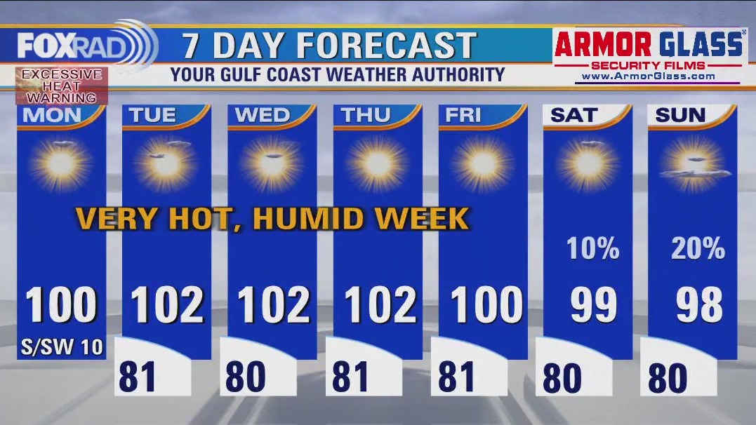
Daytime highs look to creep above 100 for most of this week, with more of a southwest wind and slightly drier air in place. The expanding heat dome will slowly drift across Texas throughout the week, leading to a prolonged stretch of dangerous heat. Inland, Excessive Heat Warnings are in place through at least Monday evening but will likely get extended. Along the coast, a Heat Advisory is in place for the same length of time. Use extreme caution if outdoors during the hottest parts of the day, but its best to avoid it if you can. Fingers crossed, by Sunday the pattern might start to break apart some.
Daytime highs look to creep above 100 for most of this week, with more of a southwest wind and slightly drier air in place. The expanding heat dome will slowly drift across Texas throughout the week, leading to a prolonged stretch of dangerous heat. Inland, Excessive Heat Warnings are in place through at least Monday evening but will likely get extended. Along the coast, a Heat Advisory is in place for the same length of time. Use extreme caution if outdoors during the hottest parts of the day, but its best to avoid it if you can. Fingers crossed, by Sunday the pattern might start to break apart some.


FOX 26 Houston Weather Forecast
Daytime highs look to creep above 100 for most of this week, with more of a southwest wind and slightly drier air in place. The expanding heat dome will slowly drift across Texas throughout the week, leading to a prolonged stretch of dangerous heat. Inland, Excessive Heat Warnings are in place through at least Monday evening but will likely get extended. Along the coast, a Heat Advisory is in place for the same length of time. Use extreme caution if outdoors during the hottest parts of the day, but its best to avoid it if you can. Fingers crossed, by Sunday the pattern might start to break apart some.
Daytime highs look to creep above 100 for most of this week, with more of a southwest wind and slightly drier air in place. The expanding heat dome will slowly drift across Texas throughout the week, leading to a prolonged stretch of dangerous heat. Inland, Excessive Heat Warnings are in place through at least Monday evening but will likely get extended. Along the coast, a Heat Advisory is in place for the same length of time. Use extreme caution if outdoors during the hottest parts of the day, but its best to avoid it if you can. Fingers crossed, by Sunday the pattern might start to break apart some.


Houston Weather: Heatwave sticks around, may intensify
The Texas heat wave will continue all week and is likely to intensify - temperatures statewide will soar into the 100-110 degree range. It's going to feel oppressively hot and humid here in Houston for the next few days, but the humidity levels should drop slightly by mid-week. That slightly drier air should also get hotter, so the hottest high temps of the season are on the way.
The Texas heat wave will continue all week and is likely to intensify - temperatures statewide will soar into the 100-110 degree range. It's going to feel oppressively hot and humid here in Houston for the next few days, but the humidity levels should drop slightly by mid-week. That slightly drier air should also get hotter, so the hottest high temps of the season are on the way.


FOX 26 Houston Weather Forecast
Heat Advisory remains in effect until Noon Sunday for Houston with an Excessive Heat Warning going into effect from Noon to 9PM Sunday. Heat index values Sunday PM could approach 115 which could lead to heat illnesses if you are not careful. Make sure you take it easy in the heat, limit time outside and drink plenty of water! This heat wave will get more dangerous over the next several days as triple digit temperatures are expected over the next week. Some record high temperatures could be tied or broken. Heat dome is getting stronger over the next week which will mean plenty of heat but very little rain. Stay safe in the heat and remember to download our FOX 26 Weather App to keep track of the building heat and what's happening in the tropics.
Heat Advisory remains in effect until Noon Sunday for Houston with an Excessive Heat Warning going into effect from Noon to 9PM Sunday. Heat index values Sunday PM could approach 115 which could lead to heat illnesses if you are not careful. Make sure you take it easy in the heat, limit time outside and drink plenty of water! This heat wave will get more dangerous over the next several days as triple digit temperatures are expected over the next week. Some record high temperatures could be tied or broken. Heat dome is getting stronger over the next week which will mean plenty of heat but very little rain. Stay safe in the heat and remember to download our FOX 26 Weather App to keep track of the building heat and what's happening in the tropics.