


FOX 26 Tuesday morning weather forecast
We're going to enjoy another pleasant, warm day across the Houston area with high temps running about 3-5 degrees above average through this weekend. Isolated showers are possibly late this week, but overall still a pretty quiet pattern. So far, no threats from the tropics for Texas.
We're going to enjoy another pleasant, warm day across the Houston area with high temps running about 3-5 degrees above average through this weekend. Isolated showers are possibly late this week, but overall still a pretty quiet pattern. So far, no threats from the tropics for Texas.


FOX 26 Houston Weather Forecast
We are starting the week off with some sunshine, warm but seasonable temperatures and lower humidity! Some areas picked up between 2-8" of rain between Thursday and Saturday which helped with our drought conditions. Tuesday will be another nice outdoors day with dry weather and temperatures climbing to the low 90s. Look for low rain chances to return Wednesday through Saturday with better chances for spotty storms Sunday and Monday. Hurricane Nigel is not expected to threaten the US and should stay east of Bermuda. It's moving NW but will turn NE later this week.
We are starting the week off with some sunshine, warm but seasonable temperatures and lower humidity! Some areas picked up between 2-8" of rain between Thursday and Saturday which helped with our drought conditions. Tuesday will be another nice outdoors day with dry weather and temperatures climbing to the low 90s. Look for low rain chances to return Wednesday through Saturday with better chances for spotty storms Sunday and Monday. Hurricane Nigel is not expected to threaten the US and should stay east of Bermuda. It's moving NW but will turn NE later this week.


FOX 26 Houston Weather Forecast
The quiet end to the weekend gets even better for the start of the work week. Monday and Tuesday will be sunny and dry days with low humidity for Houston. Our last week of summer will be quiet with near-normal temperatures and isolated chances for showers.
The quiet end to the weekend gets even better for the start of the work week. Monday and Tuesday will be sunny and dry days with low humidity for Houston. Our last week of summer will be quiet with near-normal temperatures and isolated chances for showers.


FOX 26 Houston Weather Forecast
Ironically, our last week of summer will be quiet with near-normal temperatures. I guess we've earned it! A stray shower is possible along the coast today as the stationary front that brought us several days worth of rain departs, but isolated showers may return later this week. Otherwise, look forward to sunny, dry days with low humidity. In the Tropics, we have a newly named storm, but no local concerns at this time.
Ironically, our last week of summer will be quiet with near-normal temperatures. I guess we've earned it! A stray shower is possible along the coast today as the stationary front that brought us several days worth of rain departs, but isolated showers may return later this week. Otherwise, look forward to sunny, dry days with low humidity. In the Tropics, we have a newly named storm, but no local concerns at this time.


FOX 26 Saturday evening weather forecast
Southeast Texas has seen several rounds of rain and heavy downpours over the past couple days. Look for the weekend to end quieter. Houston could see some rain on Sunday but it will be only isolated chances. The week starts with close to season temperatures and slightly lower humidity levels. Temperatures should remain in the lower 90s for the rest of the week with more isolated chances for showers.
Southeast Texas has seen several rounds of rain and heavy downpours over the past couple days. Look for the weekend to end quieter. Houston could see some rain on Sunday but it will be only isolated chances. The week starts with close to season temperatures and slightly lower humidity levels. Temperatures should remain in the lower 90s for the rest of the week with more isolated chances for showers.


FOX 26 Houston Weather Forecast
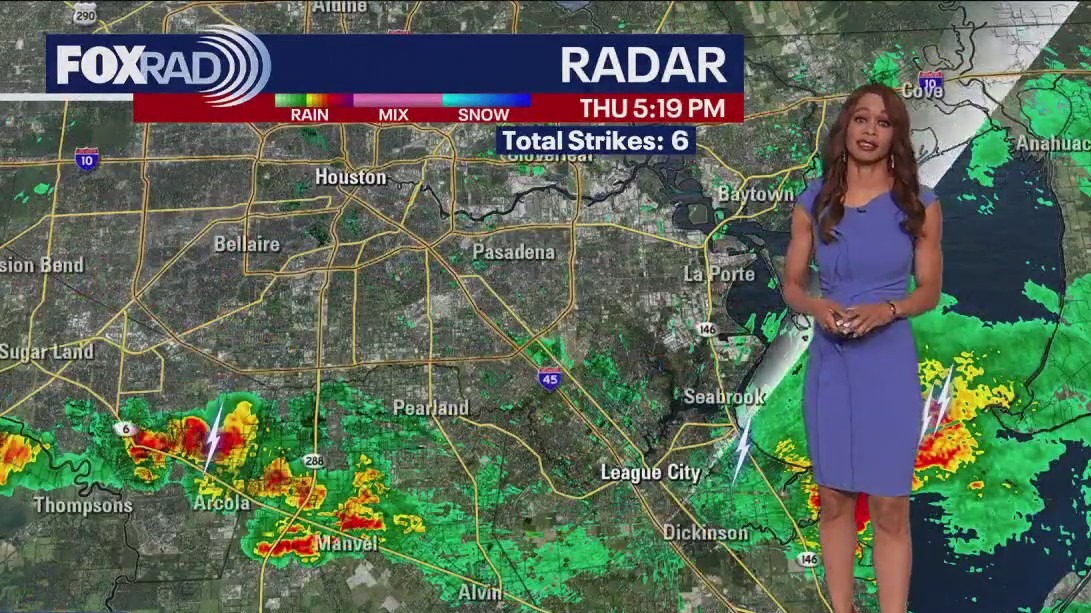
After two days of locally heavy rain and feisty storms, one more round could be on the way this afternoon and evening. Keep that in mind for outdoor plans, including college football tailgates and games. Sunday looks much drier for the Texans home opener aside from a few very isolated showers. Mornings at the start of next week are going to be fantastic so be sure to get outside! Our forecast continues to trend very normal for this time of year, and although the tropics are busy... nothing is heading out way.
After two days of locally heavy rain and feisty storms, one more round could be on the way this afternoon and evening. Keep that in mind for outdoor plans, including college football tailgates and games. Sunday looks much drier for the Texans home opener aside from a few very isolated showers. Mornings at the start of next week are going to be fantastic so be sure to get outside! Our forecast continues to trend very normal for this time of year, and although the tropics are busy... nothing is heading out way.


FOX 26 Friday evening weather forecast
Strong to severe storms have been rolling across SE TX with the threat for flooding, damaging winds and hail. We need the heavy rain but watch out for some street flooding. Flash Flood Warning is in effect for SE Harris and NW Galveston counties until 7:30 pm. 2-4" of rain have fallen in this area and some flooding is likely through early evening. Look for isolated to spotty showers and storms this weekend with near average temperatures in the low 90s. The trend for next week is less rain and a little more heat as we climb to the middle 90s.
Strong to severe storms have been rolling across SE TX with the threat for flooding, damaging winds and hail. We need the heavy rain but watch out for some street flooding. Flash Flood Warning is in effect for SE Harris and NW Galveston counties until 7:30 pm. 2-4" of rain have fallen in this area and some flooding is likely through early evening. Look for isolated to spotty showers and storms this weekend with near average temperatures in the low 90s. The trend for next week is less rain and a little more heat as we climb to the middle 90s.


FOX 26 Houston Weather Forecast
Scattered storms return today, including the possibility for a few stronger storms and downpours. Rain looks more isolated in nature for tomorrow. The end of the weekend and next week start off nice! Temperatures look to remain reasonable next week, with a few midweek showers possible. Margot is still a Hurricane, but impacting no one in the north-central Atlantic. Lee is brushing by Bermuda, then New England and Coastal Canada heading into the weekend. There are two other areas to watch in the Atlantic, with no local threats at this time.
Scattered storms return today, including the possibility for a few stronger storms and downpours. Rain looks more isolated in nature for tomorrow. The end of the weekend and next week start off nice! Temperatures look to remain reasonable next week, with a few midweek showers possible. Margot is still a Hurricane, but impacting no one in the north-central Atlantic. Lee is brushing by Bermuda, then New England and Coastal Canada heading into the weekend. There are two other areas to watch in the Atlantic, with no local threats at this time.


FOX 26 Houston Weather Forecast
Scattered storms return today, including the possibility for a few stronger storms and downpours. Rain looks more isolated in nature for tomorrow. The end of the weekend and next week start off nice! Temperatures look to remain reasonable next week, with a few midweek showers possible. Margot is still a hurricane, but impacting no one in the north-central Atlantic. Lee is brushing by Bermuda, then New England and Coastal Canada heading into the weekend. There are two other areas to watch in the Atlantic, with no local threats at this time.
Scattered storms return today, including the possibility for a few stronger storms and downpours. Rain looks more isolated in nature for tomorrow. The end of the weekend and next week start off nice! Temperatures look to remain reasonable next week, with a few midweek showers possible. Margot is still a hurricane, but impacting no one in the north-central Atlantic. Lee is brushing by Bermuda, then New England and Coastal Canada heading into the weekend. There are two other areas to watch in the Atlantic, with no local threats at this time.


FOX 26 Houston Weather Forecast
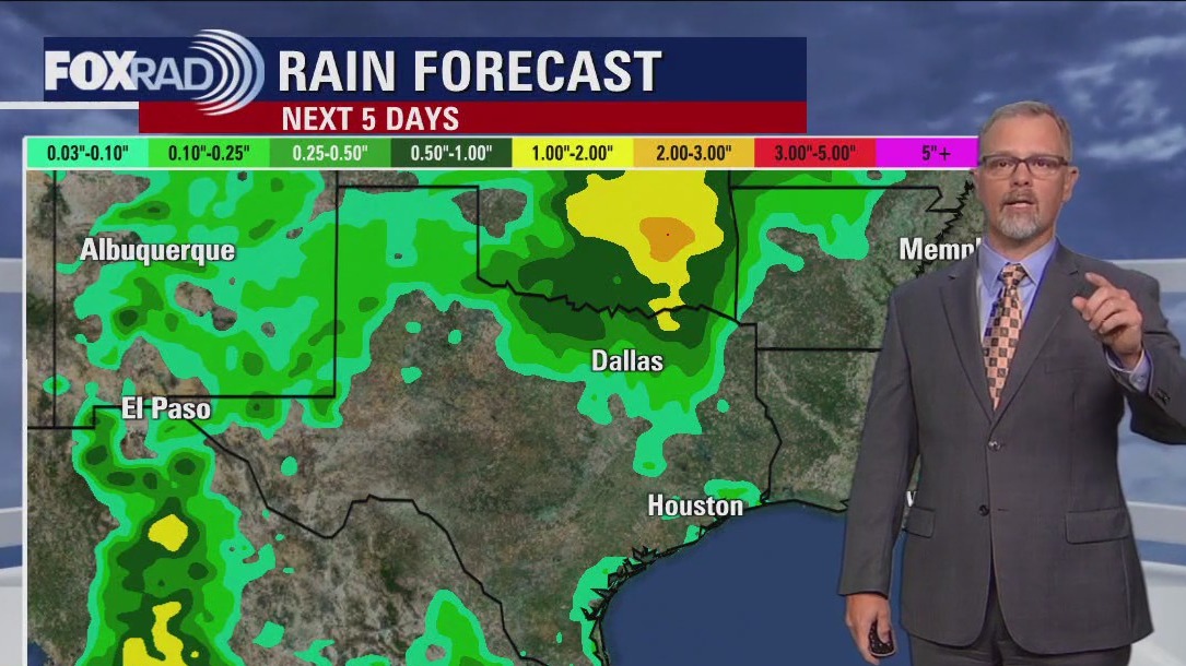
More widespread beneficial rain has arrived across SE Texas with the threat for a few strong to severe storms also possible. Main threats with these storms will be isolated damaging winds, hail around 1" and very heavy rain that could lead to some street flooding. Some of these storms have dumped 1-3" of rain across the area today helping with the worsening drought conditions. Best storm chance will be through early tonight but a few showers and storms will be possible overnight. We will repeat this again Friday with another round of storms expected during the afternoon and evening. Rain chances get lower this weekend, around 30-40%. Looking ahead to next week, isolated rain will stick around with temperatures climbing back up to the middle 90s as our heat dome tries to build back in.
More widespread beneficial rain has arrived across SE Texas with the threat for a few strong to severe storms also possible. Main threats with these storms will be isolated damaging winds, hail around 1" and very heavy rain that could lead to some street flooding. Some of these storms have dumped 1-3" of rain across the area today helping with the worsening drought conditions. Best storm chance will be through early tonight but a few showers and storms will be possible overnight. We will repeat this again Friday with another round of storms expected during the afternoon and evening. Rain chances get lower this weekend, around 30-40%. Looking ahead to next week, isolated rain will stick around with temperatures climbing back up to the middle 90s as our heat dome tries to build back in.

FOX 26 Thursday weather forecast
More widespread beneficial rain has arrived across SE Texas with the threat for a few strong to severe storms also possible. Main threats with these storms will be isolated damaging winds, hail around 1" and very heavy rain that could lead to some street flooding. Some of these storms have dumped 1-3" of rain across the area today helping with the worsening drought conditions. Best storm chance will be through early tonight but a few showers and storms will be possible overnight. We will repeat this again Friday with another round of storms expected during the afternoon and evening. Rain chances get lower this weekend, around 30-40%. Looking ahead to next week, isolated rain will stick around with temperatures climbing back up to the middle 90s as our heat dome tries to build back in.
More widespread beneficial rain has arrived across SE Texas with the threat for a few strong to severe storms also possible. Main threats with these storms will be isolated damaging winds, hail around 1" and very heavy rain that could lead to some street flooding. Some of these storms have dumped 1-3" of rain across the area today helping with the worsening drought conditions. Best storm chance will be through early tonight but a few showers and storms will be possible overnight. We will repeat this again Friday with another round of storms expected during the afternoon and evening. Rain chances get lower this weekend, around 30-40%. Looking ahead to next week, isolated rain will stick around with temperatures climbing back up to the middle 90s as our heat dome tries to build back in.


FOX 26 Houston Weather
Get ready for more rain and even the chance for heavy rain, isolated street flooding and isolated severe storms today. More than 2" of rain could be common after midday along with frequent lightning. If today's high temp stays below 89?, it would be the first time since June 6th! Beyond today, look for scattered storms Friday and a few showers and storms this weekend.
Get ready for more rain and even the chance for heavy rain, isolated street flooding and isolated severe storms today. More than 2" of rain could be common after midday along with frequent lightning. If today's high temp stays below 89?, it would be the first time since June 6th! Beyond today, look for scattered storms Friday and a few showers and storms this weekend.


FOX 26 Houston Weather Forecast
Houston is finally getting a decent shot for more widespread rain the next few days. Multiple rounds of rain are expected with some heavy rain possible. We are in a marginal risk for excessive rain that could lead to a little street flooding today and tomorrow. Widespread 1-2" rain totals are expected the next few days with isolated higher amounts. A few strong storms could produce some wind gusts wind near 40-50 mph. Widespread severe weather is not expected. Temperatures are more comfortable the next few days with heat building again next week. Rain chances go back to isolated by Sunday. Hurricane Lee will remains a threat to New England where hurricane and tropical storm watches are now in effect.
Houston is finally getting a decent shot for more widespread rain the next few days. Multiple rounds of rain are expected with some heavy rain possible. We are in a marginal risk for excessive rain that could lead to a little street flooding today and tomorrow. Widespread 1-2" rain totals are expected the next few days with isolated higher amounts. A few strong storms could produce some wind gusts wind near 40-50 mph. Widespread severe weather is not expected. Temperatures are more comfortable the next few days with heat building again next week. Rain chances go back to isolated by Sunday. Hurricane Lee will remains a threat to New England where hurricane and tropical storm watches are now in effect.


FOX 26 Wednesday evening weather forecast
Houston is finally getting a decent shot for more widespread rain the next few days. Multiple rounds of rain are expected with some heavy rain possible. We are in a marginal risk for excessive rain that could lead to a little street flooding today and tomorrow. Widespread 1-2" rain totals are expected the next few days with isolated higher amounts. A few strong storms could produce some wind gusts wind near 40-50 mph. Widespread severe weather is not expected. Temperatures are more comfortable the next few days with heat building again next week. Rain chances go back to isolated by Sunday. Hurricane Lee will remains a threat to New England where hurricane and tropical storm watches are now in effect.
Houston is finally getting a decent shot for more widespread rain the next few days. Multiple rounds of rain are expected with some heavy rain possible. We are in a marginal risk for excessive rain that could lead to a little street flooding today and tomorrow. Widespread 1-2" rain totals are expected the next few days with isolated higher amounts. A few strong storms could produce some wind gusts wind near 40-50 mph. Widespread severe weather is not expected. Temperatures are more comfortable the next few days with heat building again next week. Rain chances go back to isolated by Sunday. Hurricane Lee will remains a threat to New England where hurricane and tropical storm watches are now in effect.


Fox 26 Weather Forecast
A pattern change has arrived and rain looks likely for the next few days. Our long-lived "heat dome" has dissipated and a more active jet stream pattern will replace it through at least Saturday. A few heavy downpours are possible from late today through Thursday and Friday. High temps should be held to at or even below average which will be a nice break. Today is the 15th anniversary of Hurricane Ike making landfall in Galveston, but we are currently not under any tropical threats.
A pattern change has arrived and rain looks likely for the next few days. Our long-lived "heat dome" has dissipated and a more active jet stream pattern will replace it through at least Saturday. A few heavy downpours are possible from late today through Thursday and Friday. High temps should be held to at or even below average which will be a nice break. Today is the 15th anniversary of Hurricane Ike making landfall in Galveston, but we are currently not under any tropical threats.


FOX 26 Houston Weather Forecast
Houston is finally going to get a nice pattern change with less heat and more rain! Look for increasing clouds with scattered showers and storms Wednesday. Rain chances get even higher Thursday and Friday. 1-2" of rain will be a good bet for much of the area Wednesday through Friday with isolated higher totals. This will not erase the drought but will at least put a little dent in it. Rain chances get a bit lower this weekend but they still hang around. Temperatures will be more comfortable with more clouds and rain around. It will get a bit hotter next week but it will not be the extreme temperatures we have dealt with in recent weeks.
Houston is finally going to get a nice pattern change with less heat and more rain! Look for increasing clouds with scattered showers and storms Wednesday. Rain chances get even higher Thursday and Friday. 1-2" of rain will be a good bet for much of the area Wednesday through Friday with isolated higher totals. This will not erase the drought but will at least put a little dent in it. Rain chances get a bit lower this weekend but they still hang around. Temperatures will be more comfortable with more clouds and rain around. It will get a bit hotter next week but it will not be the extreme temperatures we have dealt with in recent weeks.


FOX 26 Tuesday evening weather forecast
Houston is finally going to get a nice pattern change with less heat and more rain! Look for increasing clouds with scattered showers and storms Wednesday. Rain chances get even higher Thursday and Friday. 1-2" of rain will be a good bet for much of the area Wednesday through Friday with isolated higher totals. This will not erase the drought but will at least put a little dent in it. Rain chances get a bit lower this weekend but they still hang around. Temperatures will be more comfortable with more clouds and rain around. It will get a bit hotter next week but it will not be the extreme temperatures we have dealt with in recent weeks.
Houston is finally going to get a nice pattern change with less heat and more rain! Look for increasing clouds with scattered showers and storms Wednesday. Rain chances get even higher Thursday and Friday. 1-2" of rain will be a good bet for much of the area Wednesday through Friday with isolated higher totals. This will not erase the drought but will at least put a little dent in it. Rain chances get a bit lower this weekend but they still hang around. Temperatures will be more comfortable with more clouds and rain around. It will get a bit hotter next week but it will not be the extreme temperatures we have dealt with in recent weeks.


FOX 26 Houston Weather Forecast
Some relief is finally in sight in the form of clouds and scattered storms that should begin tomorrow and stretch through at least Friday. This pattern change could put a small dent in the drought across the state of Texas and for us, should shave a few degrees off of our daily highs.
Some relief is finally in sight in the form of clouds and scattered storms that should begin tomorrow and stretch through at least Friday. This pattern change could put a small dent in the drought across the state of Texas and for us, should shave a few degrees off of our daily highs.