

Houston weather: More rainfall possible Sunday, Monday
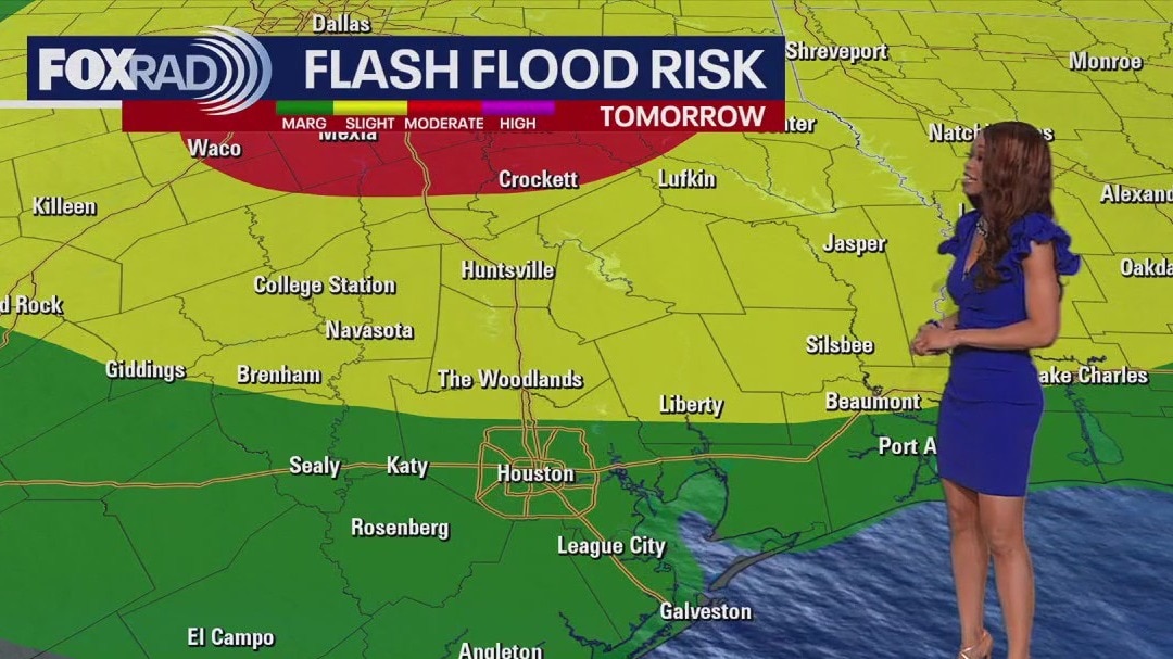
Flood Watch has been issued for Walker, San Jacinto, Polk & Trinity counties from 7 AM Sunday until 7 AM Monday. Additional 2-4" of rain is possible in this area Sunday and Monday with isolated higher totals. 2-3" of rain is expected around Houston the next few days. A few strong to severe storms are also possible Sunday and Monday with winds near 60 mph and hail 1+" a possibility. So stay alert on Mother's Day for a few severe storms and a few flooded streets. Biggest flood and severe storm risk Sunday will be north of Houston. River flooding continues along the Brazos and Trinity Rivers from recent rain. So additional flooding issues could develop in these locations quickly. Most of the rain will move out Tuesday & Wednesday before showers and storms increase again Thursday. Download our FOX 26 weather and Fox Local smart tv app to keep track of all the holiday weekend weather changes where you live.
Flood Watch has been issued for Walker, San Jacinto, Polk & Trinity counties from 7 AM Sunday until 7 AM Monday. Additional 2-4" of rain is possible in this area Sunday and Monday with isolated higher totals. 2-3" of rain is expected around Houston the next few days. A few strong to severe storms are also possible Sunday and Monday with winds near 60 mph and hail 1+" a possibility. So stay alert on Mother's Day for a few severe storms and a few flooded streets. Biggest flood and severe storm risk Sunday will be north of Houston. River flooding continues along the Brazos and Trinity Rivers from recent rain. So additional flooding issues could develop in these locations quickly. Most of the rain will move out Tuesday & Wednesday before showers and storms increase again Thursday. Download our FOX 26 weather and Fox Local smart tv app to keep track of all the holiday weekend weather changes where you live.

FOX 26 Houston Weather Forecast: Rain moving back in
Flood Watch has been issued for Walker, San Jacinto, Polk & Trinity counties from 7 AM Sunday until 7 AM Monday. Additional 2-4" of rain is possible in this area Sunday and Monday with isolated higher totals. 2-3" of rain is expected around Houston the next few days. A few strong to severe storms are also possible Sunday and Monday with winds near 60 mph and hail 1+" a possibility. So stay alert on Mother's Day for a few severe storms and a few flooded streets. Biggest flood and severe storm risk Sunday will be north of Houston. River flooding continues along the Brazos and Trinity Rivers from recent rain. So additional flooding issues could develop in these locations quickly. Most of the rain will move out Tuesday & Wednesday before showers and storms increase again Thursday. Download our FOX 26 weather and Fox Local smart tv app to keep track of all the holiday weekend weather changes where you live.
Flood Watch has been issued for Walker, San Jacinto, Polk & Trinity counties from 7 AM Sunday until 7 AM Monday. Additional 2-4" of rain is possible in this area Sunday and Monday with isolated higher totals. 2-3" of rain is expected around Houston the next few days. A few strong to severe storms are also possible Sunday and Monday with winds near 60 mph and hail 1+" a possibility. So stay alert on Mother's Day for a few severe storms and a few flooded streets. Biggest flood and severe storm risk Sunday will be north of Houston. River flooding continues along the Brazos and Trinity Rivers from recent rain. So additional flooding issues could develop in these locations quickly. Most of the rain will move out Tuesday & Wednesday before showers and storms increase again Thursday. Download our FOX 26 weather and Fox Local smart tv app to keep track of all the holiday weekend weather changes where you live.

FOX 26 Houston Weather Forecast
Happy Mother?s Day Weekend! Houston can expect a few passing showers today, but it won?t be a washout. Temperatures will be in the mid-80s with northeasterly breezes. Sunday and Monday feature heavy rain and the chance for strong to severe storms. Most of the viewing area north of I-10 are under a 1/5 risk for damaging wind gusts and hail on Sunday. There is a chance for flooding as our latest models are hinting at 1-5? of rain in total through early next week. If you have any outdoor plans with mom or you are heading to an event around town this weekend, make sure to stay weather aware. Download FOX Local and the FOX 26 weather app to stay up-to-date on weather conditions where you live.
Happy Mother?s Day Weekend! Houston can expect a few passing showers today, but it won?t be a washout. Temperatures will be in the mid-80s with northeasterly breezes. Sunday and Monday feature heavy rain and the chance for strong to severe storms. Most of the viewing area north of I-10 are under a 1/5 risk for damaging wind gusts and hail on Sunday. There is a chance for flooding as our latest models are hinting at 1-5? of rain in total through early next week. If you have any outdoor plans with mom or you are heading to an event around town this weekend, make sure to stay weather aware. Download FOX Local and the FOX 26 weather app to stay up-to-date on weather conditions where you live.

FOX 26 Houston Weather Forecast
Say hello to Mother's Day weekend! Much of Saturday should be dry with a few showers building in from the west late. Rain really increases Sunday and Monday with a few strong storms possible Sunday PM. Houston and areas west are under a 1/5 risk for severe storms on Sunday. Damaging winds and hail will be the main threats but the risk is low for now. There's a bigger chance for flooding on Sunday and Monday as models are indicating anywhere from 1 to 5" of rain possible. Be especially careful around the Brazos and Trinity Rivers where flooding continues from previous rain. At least temperatures will be more comfortable this weekend as you're hanging out with Mom or enjoying an event around town. Keep track of the weather where you live and the flood risk by checking out in-depth forecasts on FOX Local and our FOX 26 Weather App!
Say hello to Mother's Day weekend! Much of Saturday should be dry with a few showers building in from the west late. Rain really increases Sunday and Monday with a few strong storms possible Sunday PM. Houston and areas west are under a 1/5 risk for severe storms on Sunday. Damaging winds and hail will be the main threats but the risk is low for now. There's a bigger chance for flooding on Sunday and Monday as models are indicating anywhere from 1 to 5" of rain possible. Be especially careful around the Brazos and Trinity Rivers where flooding continues from previous rain. At least temperatures will be more comfortable this weekend as you're hanging out with Mom or enjoying an event around town. Keep track of the weather where you live and the flood risk by checking out in-depth forecasts on FOX Local and our FOX 26 Weather App!

FOX 26 Houston Weather Forecast
Say hello to Mother's Day weekend! Much of Saturday should be dry with a few showers building in from the west late. Rain really increases Sunday and Monday with a few strong storms possible Sunday PM. Houston and areas west are under a 1/5 risk for severe storms Sunday. Damaging winds and hail will be the main threats but the risk is low for now. There's a bigger chance for flooding Sunday and Monday as models are indicating anywhere from 1 to 5" of rain possible. Be especially careful around the Brazos and Trinity Rivers where flooding continues from previous rain. At least temperatures will be more comfortable this weekend as you're hanging out with mom or enjoying an event around town. Keep track of the weather where you live and the flood risk by checking out in-depth forecasts on FOX Local and our FOX 26 Weather App!
Say hello to Mother's Day weekend! Much of Saturday should be dry with a few showers building in from the west late. Rain really increases Sunday and Monday with a few strong storms possible Sunday PM. Houston and areas west are under a 1/5 risk for severe storms Sunday. Damaging winds and hail will be the main threats but the risk is low for now. There's a bigger chance for flooding Sunday and Monday as models are indicating anywhere from 1 to 5" of rain possible. Be especially careful around the Brazos and Trinity Rivers where flooding continues from previous rain. At least temperatures will be more comfortable this weekend as you're hanging out with mom or enjoying an event around town. Keep track of the weather where you live and the flood risk by checking out in-depth forecasts on FOX Local and our FOX 26 Weather App!

FOX 26 Weather Forecast
Following a brief round of fast moving severe thunderstorms north and west of Houston last night, today looks much calmer. Expect breezy north winds to kick in, which will lower our humidity slightly. It will still be very warm. Heading into the Mother?s Day weekend, rain chances will increase late in the day Saturday and both Mother?s Day and Monday are still shaping up to be pretty wet with 2 to 3 inches of rain possible.
Following a brief round of fast moving severe thunderstorms north and west of Houston last night, today looks much calmer. Expect breezy north winds to kick in, which will lower our humidity slightly. It will still be very warm. Heading into the Mother?s Day weekend, rain chances will increase late in the day Saturday and both Mother?s Day and Monday are still shaping up to be pretty wet with 2 to 3 inches of rain possible.

FOX 26 Houston Weather Forecast
Following a brief round of fast-moving severe thunderstorms north and west of Houston last night, today looks much calmer. Expect breezy north winds to kick in, which will lower our humidity slightly. It will still be very warm. Heading into the Mother?s Day weekend, rain chances will increase late in the day Saturday and both Mother?s Day and Monday are still shaping up to be pretty wet with 2 to 3 inches of rain possible.
Following a brief round of fast-moving severe thunderstorms north and west of Houston last night, today looks much calmer. Expect breezy north winds to kick in, which will lower our humidity slightly. It will still be very warm. Heading into the Mother?s Day weekend, rain chances will increase late in the day Saturday and both Mother?s Day and Monday are still shaping up to be pretty wet with 2 to 3 inches of rain possible.
FOX 26 Houston Weather Forecast
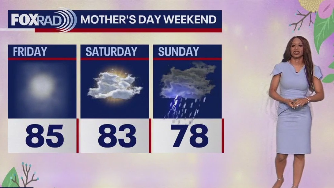
After another super-steamy day, a cold front tonight will bring us slight relief from the heat and humidity along with the threat for a few strong to severe storms. Best shot for storms will be through midnight with the cold front pushing through early Friday. The highest severe risk tonight is north of Houston From Conroe to Huntsville. Damaging winds and large hail are the main risks along with some heavy downpours. Friday and Saturday should be a bit less hot and mainly dry. Few showers will return late Saturday with widespread rain returning for Mother's Day Sunday and lingering Monday. An additional 1-3" of rain during this time will bring an elevated flood threat so stay alert. For more on the weather where you live and a more detailed Mother's Day forecast, download our smart TV app FOX Local!
After another super-steamy day, a cold front tonight will bring us slight relief from the heat and humidity along with the threat for a few strong to severe storms. Best shot for storms will be through midnight with the cold front pushing through early Friday. The highest severe risk tonight is north of Houston From Conroe to Huntsville. Damaging winds and large hail are the main risks along with some heavy downpours. Friday and Saturday should be a bit less hot and mainly dry. Few showers will return late Saturday with widespread rain returning for Mother's Day Sunday and lingering Monday. An additional 1-3" of rain during this time will bring an elevated flood threat so stay alert. For more on the weather where you live and a more detailed Mother's Day forecast, download our smart TV app FOX Local!

FOX 26 Houston Weather Forecast
After another super-steamy day, a cold front tonight will bring us slight relief from the heat and humidity along with the threat for a few strong to severe storms. Best shot for storms will be through midnight with the cold front pushing through early Friday. Highest severe risk tonight is north of Houston From Conroe to Huntsville. Damaging winds and large hail are the main risks along with some heavy downpours. Friday and Saturday should be a bit less hot and mainly dry. Few showers will return late Saturday with widespread rain returning for Mother's Day Sunday and lingering Monday. Additional 1-3" of rain during this time will bring an elevated flood threat so stay alert. For more on weather where you live and a more detailed Mother's Day forecast, download our smart tv app Fox Local!
After another super-steamy day, a cold front tonight will bring us slight relief from the heat and humidity along with the threat for a few strong to severe storms. Best shot for storms will be through midnight with the cold front pushing through early Friday. Highest severe risk tonight is north of Houston From Conroe to Huntsville. Damaging winds and large hail are the main risks along with some heavy downpours. Friday and Saturday should be a bit less hot and mainly dry. Few showers will return late Saturday with widespread rain returning for Mother's Day Sunday and lingering Monday. Additional 1-3" of rain during this time will bring an elevated flood threat so stay alert. For more on weather where you live and a more detailed Mother's Day forecast, download our smart tv app Fox Local!

FOX 26 Houston Weather Forecast
Welcome to another extremely steamy day with summer-like temps this morning and an afternoon heat index near 100. This evening's forecast is tricky and poorly predicted by our models, but there is a chance one or two strong or severe storms could race in between 8 p.m. and midnight. Otherwise, expect a more pleasant day tomorrow, but heavy rain could return by Mother's Day and Monday.
Welcome to another extremely steamy day with summer-like temps this morning and an afternoon heat index near 100. This evening's forecast is tricky and poorly predicted by our models, but there is a chance one or two strong or severe storms could race in between 8 p.m. and midnight. Otherwise, expect a more pleasant day tomorrow, but heavy rain could return by Mother's Day and Monday.

FOX 26 Houston Weather Forecast
Temperatures will once again soar to near 90 Thursday afternoon ahead of a cold front. That front drops in late Thursday and will bring the chance for a few strong to severe storms. Best chance will be north of I-10 from 6-11 pm. Slightly cooler air & lower humidity returns Friday and Saturday. But another system could cause you some problems with your Mother's Day plans Sunday. Rounds of heavy rain are expected Sunday and Monday that could bring in an additional 2-3" of rain. There's still major flooding happening along parts of the Trinity River. So that means this rain could cause even more flooding issues. So stay alert and keep track of weather where you live by downloading our FOX 26 Wx App or watching our extra coverage and exclusives on FOX Local!
Temperatures will once again soar to near 90 Thursday afternoon ahead of a cold front. That front drops in late Thursday and will bring the chance for a few strong to severe storms. Best chance will be north of I-10 from 6-11 pm. Slightly cooler air & lower humidity returns Friday and Saturday. But another system could cause you some problems with your Mother's Day plans Sunday. Rounds of heavy rain are expected Sunday and Monday that could bring in an additional 2-3" of rain. There's still major flooding happening along parts of the Trinity River. So that means this rain could cause even more flooding issues. So stay alert and keep track of weather where you live by downloading our FOX 26 Wx App or watching our extra coverage and exclusives on FOX Local!

FOX 26 Houston Weather Forecast
Temperatures will once again soar to near 90 Thursday afternoon ahead of a cold front. That front drops in late Thursday and will bring the chance for a few strong to severe storms. Best chance will be north of I-10 from 6-11 pm. Slightly cooler air & lower humidity return on Friday and Saturday. But another system could cause you some problems with your Mother's Day plans on Sunday. Rounds of heavy rain are expected Sunday and Monday that could bring in an additional 2-3" of rain. There's still major flooding happening along parts of the Trinity River. So that means this rain could cause even more flooding issues. So stay alert and keep track of the weather where you live by downloading our FOX 26 Wx App or watching our extra coverage and exclusives on FOX Local!
Temperatures will once again soar to near 90 Thursday afternoon ahead of a cold front. That front drops in late Thursday and will bring the chance for a few strong to severe storms. Best chance will be north of I-10 from 6-11 pm. Slightly cooler air & lower humidity return on Friday and Saturday. But another system could cause you some problems with your Mother's Day plans on Sunday. Rounds of heavy rain are expected Sunday and Monday that could bring in an additional 2-3" of rain. There's still major flooding happening along parts of the Trinity River. So that means this rain could cause even more flooding issues. So stay alert and keep track of the weather where you live by downloading our FOX 26 Wx App or watching our extra coverage and exclusives on FOX Local!

FOX 26 Houston Weather Forecast
Muggy and misty this morning, then very warm and humid with highs near 90.
Muggy and misty this morning, then very warm and humid with highs near 90.

FOX 26 Houston Weather Forecast
Muggy and misty this morning, then very warm and humid with highs near 90.
Muggy and misty this morning, then very warm and humid with highs near 90.

FOX 26 Houston Weather Forecast
The forecast for the next couple of days remains fairly quiet for Houston, but areas just to the north could see a few storms on Thursday. River flooding is still a problem in a few spots but conditions continue to slowly improve with the lack of any major rainfall. Wednesday and Thursday will have temperatures in the lower 90s with heat index values about 100. A weak cold front late Thursday will bring the next change to the weather pattern for Southeast Texas.
The forecast for the next couple of days remains fairly quiet for Houston, but areas just to the north could see a few storms on Thursday. River flooding is still a problem in a few spots but conditions continue to slowly improve with the lack of any major rainfall. Wednesday and Thursday will have temperatures in the lower 90s with heat index values about 100. A weak cold front late Thursday will bring the next change to the weather pattern for Southeast Texas.

FOX 26 Houston Weather Forecast
The forecast for the next couple of days remains fairly quiet for Houston, but areas just to the north could see a few storms on Thursday. River flooding is still a problem in a few spots but conditions continue to slowly improve with the lack of any major rainfall. Wednesday and Thursday will have temperatures in the lower 90s with heat index values about 100. A weak cold front late Thursday will bring the next change to the weather pattern for Southeast Texas.
The forecast for the next couple of days remains fairly quiet for Houston, but areas just to the north could see a few storms on Thursday. River flooding is still a problem in a few spots but conditions continue to slowly improve with the lack of any major rainfall. Wednesday and Thursday will have temperatures in the lower 90s with heat index values about 100. A weak cold front late Thursday will bring the next change to the weather pattern for Southeast Texas.

FOX 26 Houston Weather Forecast
Mostly cloudy, very warm and humid. A few isolated drizzles are possible. Highs near 90.
Mostly cloudy, very warm and humid. A few isolated drizzles are possible. Highs near 90.

FOX 26 Houston Weather Forecast - Very warm day ahead on Tuesday
Much quieter weather pattern for southeast Texas this week. Look for only slight chances for showers or drizzle to start the week. The focus will be on temperatures as afternoon highs will soar into the 90 Tuesday-Thursday. Use caution with activities outdoors, as the feels-like temps will be at or above 100. It's early in the year for that kind of heat and our bodies still need some time to adjust. A cold front Thursday night knocks the temperatures back down and could bring an isolated storm mostly likely north of Houston. Seasonal temperatures should remain into the weekend.
Much quieter weather pattern for southeast Texas this week. Look for only slight chances for showers or drizzle to start the week. The focus will be on temperatures as afternoon highs will soar into the 90 Tuesday-Thursday. Use caution with activities outdoors, as the feels-like temps will be at or above 100. It's early in the year for that kind of heat and our bodies still need some time to adjust. A cold front Thursday night knocks the temperatures back down and could bring an isolated storm mostly likely north of Houston. Seasonal temperatures should remain into the weekend.

FOX 26 Houston Weather Forecast: Heat building in
Much quieter weather pattern for southeast Texas this week. Look for only slight chances for showers or drizzle to start the week. The focus will be on temperatures as afternoon highs will soar into the 90 Tuesday-Thursday. Use caution with activities outdoors, as the feels-like temps will be at or above 100. It's early in the year for that kind of heat and our bodies still need some time to adjust. A cold front Thursday night knocks the temperatures back down and could bring an isolated storm mostly likely north of Houston. Seasonal temperatures should remain into the weekend.
Much quieter weather pattern for southeast Texas this week. Look for only slight chances for showers or drizzle to start the week. The focus will be on temperatures as afternoon highs will soar into the 90 Tuesday-Thursday. Use caution with activities outdoors, as the feels-like temps will be at or above 100. It's early in the year for that kind of heat and our bodies still need some time to adjust. A cold front Thursday night knocks the temperatures back down and could bring an isolated storm mostly likely north of Houston. Seasonal temperatures should remain into the weekend.

FOX 26 Houston Weather Forecast
Patchy morning fog, then mostly cloudy, warm and humid with only isolated showers. Highs in the mid to upper 80s.
Patchy morning fog, then mostly cloudy, warm and humid with only isolated showers. Highs in the mid to upper 80s.