


FOX 26 Houston Weather Forecast
Rain is on the way to Southeast Texas but Wednesday should be mostly dry. Look for a late-day shower as rain starts to move into Houston overnight Wednesday into Thursday morning. Most of Thursday will be a washout with several rounds of rain. Severe weather chances are low but there could be some strong winds and hail possible. Rain should end early Friday followed by a quiet but somewhat breezy pattern this weekend.
Rain is on the way to Southeast Texas but Wednesday should be mostly dry. Look for a late-day shower as rain starts to move into Houston overnight Wednesday into Thursday morning. Most of Thursday will be a washout with several rounds of rain. Severe weather chances are low but there could be some strong winds and hail possible. Rain should end early Friday followed by a quiet but somewhat breezy pattern this weekend.


FOX 26 Houston Weather Forecast
Today is the last day of winter with Spring officially beginning tonight at 10:06 p.m. Chilly air this morning will give way to a very nice, dry afternoon. However, more rain is on the way with a few drizzles tomorrow, then a round of widespread showers and storms on Thursday - looking like a washout. Rain should end early Friday followed by a nice pattern into the weekend.
Today is the last day of winter with Spring officially beginning tonight at 10:06 p.m. Chilly air this morning will give way to a very nice, dry afternoon. However, more rain is on the way with a few drizzles tomorrow, then a round of widespread showers and storms on Thursday - looking like a washout. Rain should end early Friday followed by a nice pattern into the weekend.


FOX 26 Houston Weather Forecast
Spring arrives on Tuesday and it will start off CHILLY for Houston. High temperatures in the afternoon should keep below 70 but the morning starts in the 40s. Rain chances return to the forecast Wednesday night but most of the rain arrives on Thursday. This round of precipitation should be more showers than storms, but don't be surprised if there is some thunder and lightning. The weekend looks quiet with another round of showers and storms returning for the start of next week.
Spring arrives on Tuesday and it will start off CHILLY for Houston. High temperatures in the afternoon should keep below 70 but the morning starts in the 40s. Rain chances return to the forecast Wednesday night but most of the rain arrives on Thursday. This round of precipitation should be more showers than storms, but don't be surprised if there is some thunder and lightning. The weekend looks quiet with another round of showers and storms returning for the start of next week.


FOX 26 Houston Weather Forecast
Breezy and much drier today with afternoon sun and highs in the upper 60s.
Breezy and much drier today with afternoon sun and highs in the upper 60s.


FOX 26 Houston Weather Forecast: Cold front to bring cooler weather
A cold front will bring in cooler and drier air for Monday and Tuesday with more sunshine expected. It will be downright chilly Tuesday morning with temperatures starting off in the 40s and climbing to the 60s by the afternoon. Spring officially begins at 10:06 PM Tuesday night. Look for a few showers to return Wednesday with more widespread storms possible on Thursday. A warming trend will take place as we go through the week with temperatures back close to 80 by next weekend.
A cold front will bring in cooler and drier air for Monday and Tuesday with more sunshine expected. It will be downright chilly Tuesday morning with temperatures starting off in the 40s and climbing to the 60s by the afternoon. Spring officially begins at 10:06 PM Tuesday night. Look for a few showers to return Wednesday with more widespread storms possible on Thursday. A warming trend will take place as we go through the week with temperatures back close to 80 by next weekend.


FOX 26 Houston Weather Forecast - Rain continuing tonight
Showers and a few strong storms will continue through early tonight as a cold front marches across SE Texas. A few storms could contain some hail up to 1" and winds of 40-50 mph although widespread severe weather is unlikely. Cold front will bring in cooler and drier air for Monday and Tuesday with more sunshine expected. It will be downright chilly Tuesday morning with temperatures starting off in the 40s and climbing to the 60s by the afternoon. Spring officially begins at 10:06 PM Tuesday night. Look for a few showers to return Wednesday with more widespread storms possible on Thursday. A warming trend will take place as we go through the week with temperatures back close to 80 by next weekend.
Showers and a few strong storms will continue through early tonight as a cold front marches across SE Texas. A few storms could contain some hail up to 1" and winds of 40-50 mph although widespread severe weather is unlikely. Cold front will bring in cooler and drier air for Monday and Tuesday with more sunshine expected. It will be downright chilly Tuesday morning with temperatures starting off in the 40s and climbing to the 60s by the afternoon. Spring officially begins at 10:06 PM Tuesday night. Look for a few showers to return Wednesday with more widespread storms possible on Thursday. A warming trend will take place as we go through the week with temperatures back close to 80 by next weekend.


FOX 26 Houston Weather Forecast
Widespread showers and a few isolated storms are possible until 9am. Within any of these storms, heavy rain, lighting, strong winds and even small hail is possible. Once this round of rain moves east, there is a chance for on and off showers through the afternoon hours.
Widespread showers and a few isolated storms are possible until 9am. Within any of these storms, heavy rain, lighting, strong winds and even small hail is possible. Once this round of rain moves east, there is a chance for on and off showers through the afternoon hours.


FOX 26 Houston Weather Forecast
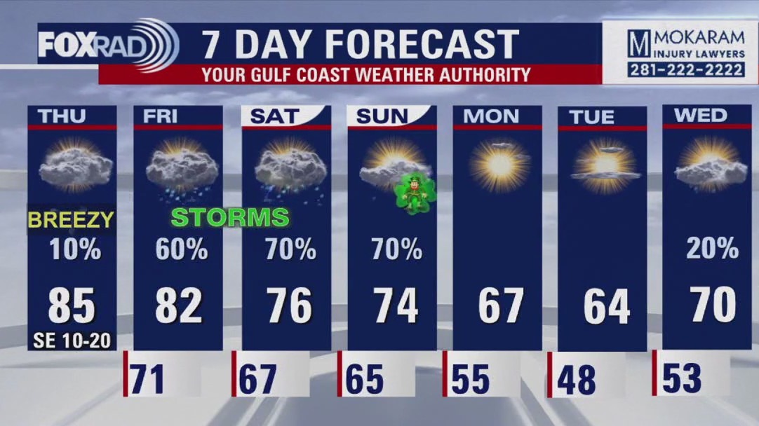
Sunday is once again a FOX 26 Storm Alert Day. A few showers and storms are possible this evening through early tonight. The severe threat through early tonight appears to be pretty low. But models are showing another big round of heavy rain and strong storms moving in from the west early Sunday morning. Timing for this appears to be from around 3 to 9 a.m.. More heavy downpours, strong winds near 60 mph and some hail will be possible. A cold front remains stalled near Houston and we will get more waves of rain through Sunday evening. But Sunday night, cold front pushes south of us ushering in cooler and drier air. That means a pleasant and brighter start to the work week on Monday. Tuesday should be mild and dry but rain and storms are back with our next system by the middle of next week. Make sure to download the FOX 26 News App and Weather App to get updates on weather that could impact your St. Patrick's Day or final day of rodeo plans! Also check out our smart tv streaming app FOX Local for extended coverage if storms turn severe!
Sunday is once again a FOX 26 Storm Alert Day. A few showers and storms are possible this evening through early tonight. The severe threat through early tonight appears to be pretty low. But models are showing another big round of heavy rain and strong storms moving in from the west early Sunday morning. Timing for this appears to be from around 3 to 9 a.m.. More heavy downpours, strong winds near 60 mph and some hail will be possible. A cold front remains stalled near Houston and we will get more waves of rain through Sunday evening. But Sunday night, cold front pushes south of us ushering in cooler and drier air. That means a pleasant and brighter start to the work week on Monday. Tuesday should be mild and dry but rain and storms are back with our next system by the middle of next week. Make sure to download the FOX 26 News App and Weather App to get updates on weather that could impact your St. Patrick's Day or final day of rodeo plans! Also check out our smart tv streaming app FOX Local for extended coverage if storms turn severe!

FOX 26 Houston Weather Forecast
Sunday is once again a FOX 26 Storm Alert Day. A few showers and storms are possible this evening through early tonight. The severe threat through early tonight appears to be pretty low. But models are showing another big round of heavy rain and strong storms moving in from the west early Sunday morning. Timing for this appears to be from around 3-9 AM. More heavy downpours, strong winds near 60 mph and some hail will be possible. A cold front remains stalled near Houston and we will get more waves of rain through Sunday evening. But Sunday night, cold front pushes south of us ushering in cooler and drier air. That means a pleasant and brighter start to the work week on Monday. Tuesday should be mild and dry but rain and storms are back with our next system by the middle of next week. Make sure to download the Fox 26 News App and Weather App to get updates on weather that could impact your St. Patrick's Day or final day of rodeo plans! Also check out our smart tv streaming app FOX Local for extended coverage if storms turn severe!
Sunday is once again a FOX 26 Storm Alert Day. A few showers and storms are possible this evening through early tonight. The severe threat through early tonight appears to be pretty low. But models are showing another big round of heavy rain and strong storms moving in from the west early Sunday morning. Timing for this appears to be from around 3-9 AM. More heavy downpours, strong winds near 60 mph and some hail will be possible. A cold front remains stalled near Houston and we will get more waves of rain through Sunday evening. But Sunday night, cold front pushes south of us ushering in cooler and drier air. That means a pleasant and brighter start to the work week on Monday. Tuesday should be mild and dry but rain and storms are back with our next system by the middle of next week. Make sure to download the Fox 26 News App and Weather App to get updates on weather that could impact your St. Patrick's Day or final day of rodeo plans! Also check out our smart tv streaming app FOX Local for extended coverage if storms turn severe!


FOX 26 Houston Weather Forecast
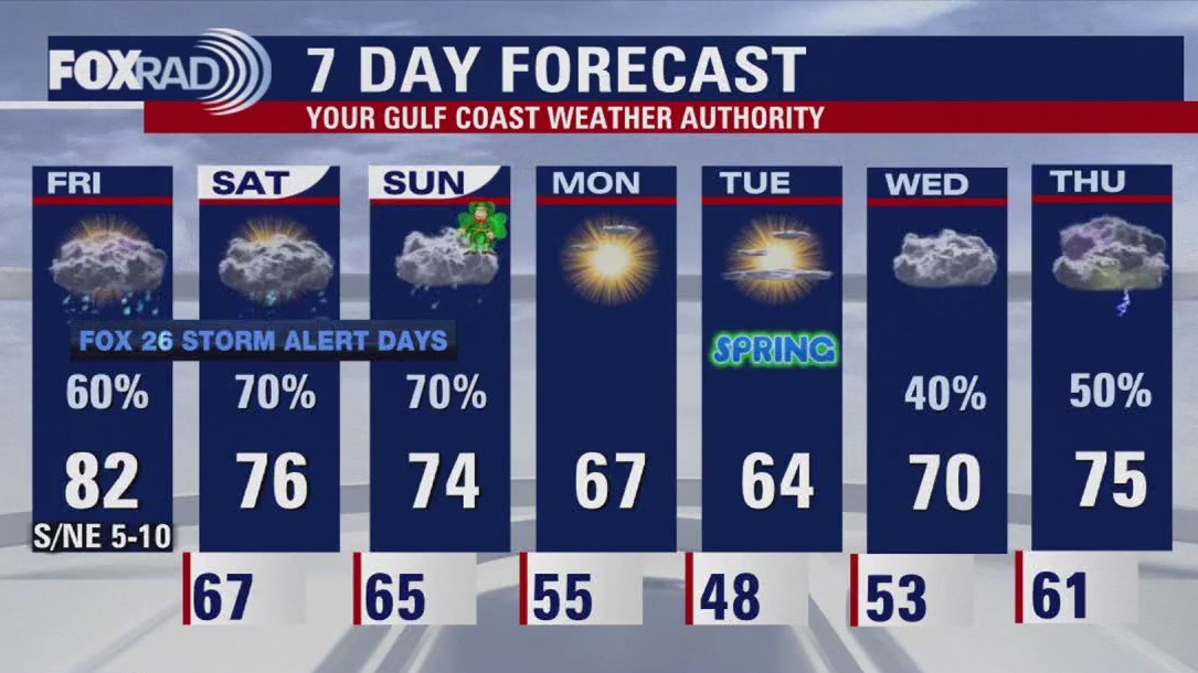
Saturday and Sunday are FOX 26 Storm Alert Days. We are monitoring the chance for several rounds of rain and a few strong storms this weekend. A front remains stalled over southeast Texas. This front keeps the threat of heavy rain, frequent lightning, strong winds, and hail through Sunday evening in Houston. The Storm Prediction Center keeps the southern portion of our viewing area in a 2/5 'Likely' risk for hail and strong winds. The Flood Threat remains widespread across the viewing area as an additional 1-3" of rain in total. Keep your umbrella handy, especially if you are heading out to the last weekend of the rodeo. Between the rounds of rain and storms, it will be humid with highs in the mid-60s and muggy conditions. A reinforcing cold front will finally sweep across the state helping to clear out the rain and drop temperatures back to the 60s to start next week.
Saturday and Sunday are FOX 26 Storm Alert Days. We are monitoring the chance for several rounds of rain and a few strong storms this weekend. A front remains stalled over southeast Texas. This front keeps the threat of heavy rain, frequent lightning, strong winds, and hail through Sunday evening in Houston. The Storm Prediction Center keeps the southern portion of our viewing area in a 2/5 'Likely' risk for hail and strong winds. The Flood Threat remains widespread across the viewing area as an additional 1-3" of rain in total. Keep your umbrella handy, especially if you are heading out to the last weekend of the rodeo. Between the rounds of rain and storms, it will be humid with highs in the mid-60s and muggy conditions. A reinforcing cold front will finally sweep across the state helping to clear out the rain and drop temperatures back to the 60s to start next week.

FOX 26 Houston Weather Forecast
After a round of severe storms Friday evening, get ready for more waves of rain and storms Saturday and Sunday. Saturday and Sunday are still FOX 26 Storm Alert Days with heavy rain likely along with a few strong storms. Cold front will remain stalled over SE Texas this weekend leading to rounds of heavy downpours and a few additional strong storms. Severe threat should be lower the next few days but the flood risk will be higher. Watch out for street flooding that could cause problems for your weekend rodeo and St. Patrick's Day plans. Additional 1-3" rain will be possible for parts of SE Texas over the weekend. So keep the rain gear close and watch out for any flooded roads. Severe storm risk for Saturday and Sunday will be lower but is still possible. Cold front finally pushes through by Sunday evening ushering in cooler and drier air for early next week. Make sure to download the Fox 26 News App and Weather App to get frequent updates on weather that could impact your spring break or rodeo plans! Also check out our smart tv streaming app FOX Local for extra severe weather coverage during this event!
After a round of severe storms Friday evening, get ready for more waves of rain and storms Saturday and Sunday. Saturday and Sunday are still FOX 26 Storm Alert Days with heavy rain likely along with a few strong storms. Cold front will remain stalled over SE Texas this weekend leading to rounds of heavy downpours and a few additional strong storms. Severe threat should be lower the next few days but the flood risk will be higher. Watch out for street flooding that could cause problems for your weekend rodeo and St. Patrick's Day plans. Additional 1-3" rain will be possible for parts of SE Texas over the weekend. So keep the rain gear close and watch out for any flooded roads. Severe storm risk for Saturday and Sunday will be lower but is still possible. Cold front finally pushes through by Sunday evening ushering in cooler and drier air for early next week. Make sure to download the Fox 26 News App and Weather App to get frequent updates on weather that could impact your spring break or rodeo plans! Also check out our smart tv streaming app FOX Local for extra severe weather coverage during this event!

FOX 26 Houston Weather Forecast
Today, tomorrow and Sunday are FOX 26 Storm Alert Days, which means that significant weather impacts are possible. This time, watch for scattered storms that could produce lots of lightning, heavy rain and even isolated hail. Rain totals could exceed 3-4", but rain will come through in waves with cloudy, humid weather in between. Check your FOX 26 weather app if you're headed to the rodeo since storms are possible.
Today, tomorrow and Sunday are FOX 26 Storm Alert Days, which means that significant weather impacts are possible. This time, watch for scattered storms that could produce lots of lightning, heavy rain and even isolated hail. Rain totals could exceed 3-4", but rain will come through in waves with cloudy, humid weather in between. Check your FOX 26 weather app if you're headed to the rodeo since storms are possible.

FOX 26 Houston Weather Forecast
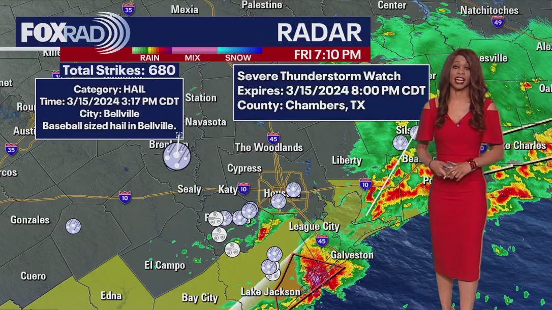
Friday, Saturday, and Sunday are now FOX 26 Storm Alert Days with the threat for a few severe storms and flooding. Make sure to download the Fox 26 News App and Weather App to get frequent updates on weather that could impact your spring break or rodeo plans! Also, check out our smart tv streaming app FOX Local for extra severe weather coverage during this event! A cold front will drop into Houston Friday and stall over the weekend. That will mean several rounds of rain Friday through Sunday with 1-3" likely with isolated higher amounts. Main severe threat will be Friday PM with hail and strong winds possible. Biggest threat will remain west of Houston around Brenham, Sealy & Columbus. Flood threat will be highest Friday near and north of I-10. An elevated flood risk will stick around for Saturday and Sunday with some flood advisories possible. Cold front finally pushes through by Sunday evening ushering in drier and slightly cooler air the early next week.
Friday, Saturday, and Sunday are now FOX 26 Storm Alert Days with the threat for a few severe storms and flooding. Make sure to download the Fox 26 News App and Weather App to get frequent updates on weather that could impact your spring break or rodeo plans! Also, check out our smart tv streaming app FOX Local for extra severe weather coverage during this event! A cold front will drop into Houston Friday and stall over the weekend. That will mean several rounds of rain Friday through Sunday with 1-3" likely with isolated higher amounts. Main severe threat will be Friday PM with hail and strong winds possible. Biggest threat will remain west of Houston around Brenham, Sealy & Columbus. Flood threat will be highest Friday near and north of I-10. An elevated flood risk will stick around for Saturday and Sunday with some flood advisories possible. Cold front finally pushes through by Sunday evening ushering in drier and slightly cooler air the early next week.


FOX 26 Houston Weather Forecast
Friday, Saturday, and Sunday are now FOX 26 Storm Alert Days with the threat of a few severe storms and flooding. Make sure to download the Fox 26 News App and Weather App to get frequent updates on weather that could impact your spring break or rodeo plans! Also, check out our smart tv streaming app FOX Local for extra severe weather coverage during this event! A cold front will drop into Houston Friday and stall over the weekend. That will mean several rounds of rain Friday through Sunday with 1-3" likely with isolated higher amounts. The main severe threat will be Friday PM with hail and strong winds possible. The biggest threat will remain west of Houston around Brenham, Sealy & Columbus. Flood threat will be highest Friday near and north of I-10. An elevated flood risk will stick around for Saturday and Sunday with some flood advisories possible. Cold front finally pushes through by Sunday evening ushering in drier and slightly cooler air the early next week.
Friday, Saturday, and Sunday are now FOX 26 Storm Alert Days with the threat of a few severe storms and flooding. Make sure to download the Fox 26 News App and Weather App to get frequent updates on weather that could impact your spring break or rodeo plans! Also, check out our smart tv streaming app FOX Local for extra severe weather coverage during this event! A cold front will drop into Houston Friday and stall over the weekend. That will mean several rounds of rain Friday through Sunday with 1-3" likely with isolated higher amounts. The main severe threat will be Friday PM with hail and strong winds possible. The biggest threat will remain west of Houston around Brenham, Sealy & Columbus. Flood threat will be highest Friday near and north of I-10. An elevated flood risk will stick around for Saturday and Sunday with some flood advisories possible. Cold front finally pushes through by Sunday evening ushering in drier and slightly cooler air the early next week.

Fox 26 Houston Weather Forecast
We have quite a few changes ahead, so be aware. Today will be cloudy, windy and warm. A cold front moves in & stalls tomorrow through Sunday, so scattered heavy downpours will be possible each day. Might be best to head to the carnival today.
We have quite a few changes ahead, so be aware. Today will be cloudy, windy and warm. A cold front moves in & stalls tomorrow through Sunday, so scattered heavy downpours will be possible each day. Might be best to head to the carnival today.


FOX 26 Houston Weather Forecast
Mostly cloudy, breezy and muggy with highs in the low to mid 80s. A few late day storms are possible north of Houston.
Mostly cloudy, breezy and muggy with highs in the low to mid 80s. A few late day storms are possible north of Houston.


FOX 26 Houston Weather Forecast
Weather has been pretty quiet so far this spring break week but things are starting to change. Warm and humid air has returned and a few showers and storms will be possible Thursday. A cold front will move in and stall across the area increasing our chance for more widespread showers and storms Friday and Saturday. Rounds of heavy rain will increase our flood threat with the highest flash flood risk expected Saturday. A few storms the next few days could also turn strong to severe with some gusty wind and hail. Best chance for this will be in our northern counties. Cold front will bring another round of showers and storms Sunday as it finally picks up speed and pushes through Houston. That will mean drier air and more comfortable temperatures as you return to work after spring break. Make sure to download our smart tv app FOXLOCAL for updates on the messy spring break weather coming plus lots of other exclusive content!
Weather has been pretty quiet so far this spring break week but things are starting to change. Warm and humid air has returned and a few showers and storms will be possible Thursday. A cold front will move in and stall across the area increasing our chance for more widespread showers and storms Friday and Saturday. Rounds of heavy rain will increase our flood threat with the highest flash flood risk expected Saturday. A few storms the next few days could also turn strong to severe with some gusty wind and hail. Best chance for this will be in our northern counties. Cold front will bring another round of showers and storms Sunday as it finally picks up speed and pushes through Houston. That will mean drier air and more comfortable temperatures as you return to work after spring break. Make sure to download our smart tv app FOXLOCAL for updates on the messy spring break weather coming plus lots of other exclusive content!

FOX 26 Houston Weather Forecast
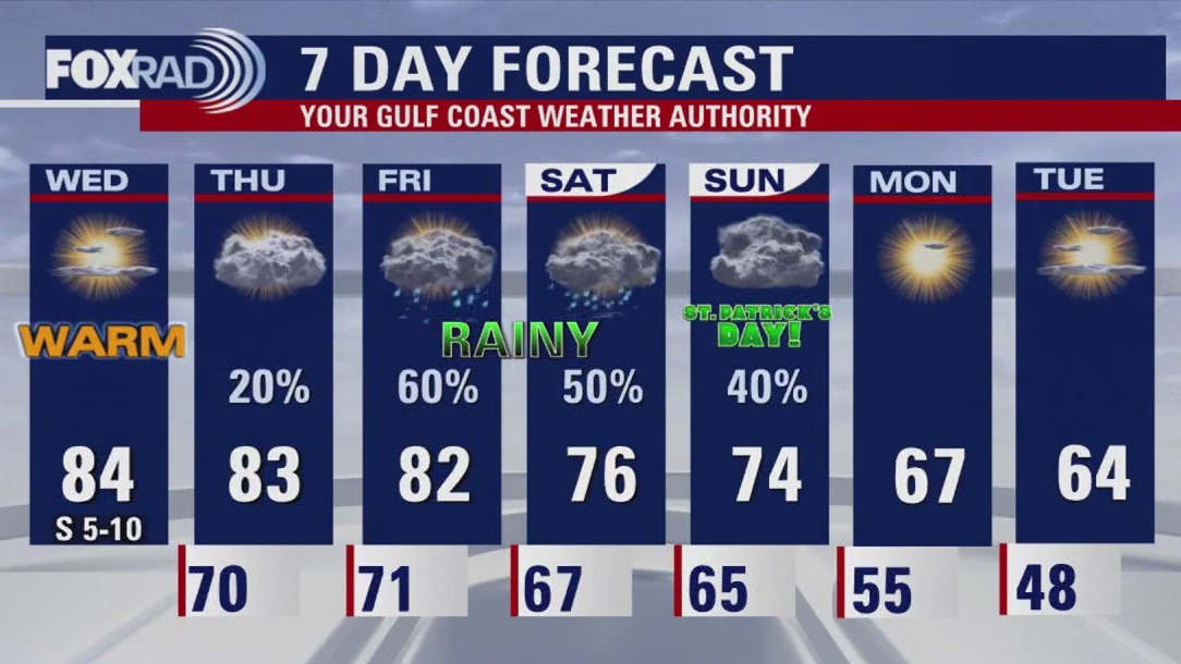
Warm and muggy conditions are expected across Houston today. Highs will soar to the 80s through the remainder of the week. A front is forecast to stall over the region bringing several rounds of rain and storms possible. For now, the Storm Prediction Center has put a portion of our northern viewing area under a 1/5 'Possible' risk for any severe weather on Friday. Heavy rain and strong winds are possible. A cooling front sweeps through Houston on Sunday helping to drop highs on Monday back to the 60s.
Warm and muggy conditions are expected across Houston today. Highs will soar to the 80s through the remainder of the week. A front is forecast to stall over the region bringing several rounds of rain and storms possible. For now, the Storm Prediction Center has put a portion of our northern viewing area under a 1/5 'Possible' risk for any severe weather on Friday. Heavy rain and strong winds are possible. A cooling front sweeps through Houston on Sunday helping to drop highs on Monday back to the 60s.