


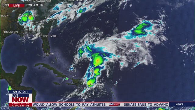
Continuing to monitor two potential systems | FOX 26 Tropical Weather Forecast
Two areas are still being monitored for tropical development. One is in the west-central Atlantic and the other is in the western Caribbean near Central America. Invest 94-L in the Atlantic is a few hundred miles east of the Leeward Islands with a Low 30% chance of development into a tropical system. It could reach Puerto Rico and Hispaniola this weekend as a tropical depression or storm. But strong upper-level winds should end development chances by late in the weekend. Broad area of low pressure in the western Caribbean also has a low 30% chance to develop into a tropical system. The window is brief since it is expected to make landfall in Central America and Southern Mexico this weekend.
Two areas are still being monitored for tropical development. One is in the west-central Atlantic and the other is in the western Caribbean near Central America. Invest 94-L in the Atlantic is a few hundred miles east of the Leeward Islands with a Low 30% chance of development into a tropical system. It could reach Puerto Rico and Hispaniola this weekend as a tropical depression or storm. But strong upper-level winds should end development chances by late in the weekend. Broad area of low pressure in the western Caribbean also has a low 30% chance to develop into a tropical system. The window is brief since it is expected to make landfall in Central America and Southern Mexico this weekend.

Hurricane season is nearing the endgame, but what can we expect in its final weeks?
Despite an average number of storms so far, this season has the potential to rank among the top four destructive in U.S. history. But hurricane season still has about six weeks left -- what more can we expect?
Despite an average number of storms so far, this season has the potential to rank among the top four destructive in U.S. history. But hurricane season still has about six weeks left -- what more can we expect?
Hurricane recovery and preparing car for the cold
Chief Meteorologist Mike Iscovitz takes a look at ongoign hurricane recovery efforts in Texas and Florida. Also, John Dawson talks to Mark Beckett with Jiffy Lube about how to prepare your car for cold weather.
Chief Meteorologist Mike Iscovitz takes a look at ongoign hurricane recovery efforts in Texas and Florida. Also, John Dawson talks to Mark Beckett with Jiffy Lube about how to prepare your car for cold weather.

FOX 26 Houston Weather Forecast
Wow! Our temperatures this morning were the coolest since early April and we have some beautiful weather ahead today. Expect lots of sunshine, very dry air and lighter winds than yesterday. Speaking of yesterday, it was the first time in more than a month that the temperature was below average. One issue to be aware of - with very little rain over the last few weeks, we are slipping back into a drought and many local counties have outdoor burn bans in effect. Grass or brush fires are possible, so let's do everything to avoid that. Over the next 5-7 days, we'll feel conditions gradually get more humid and highs could return to near 90 by next week. Allergy levels, especially ragweed, should remain high for the foreseeable future.
Wow! Our temperatures this morning were the coolest since early April and we have some beautiful weather ahead today. Expect lots of sunshine, very dry air and lighter winds than yesterday. Speaking of yesterday, it was the first time in more than a month that the temperature was below average. One issue to be aware of - with very little rain over the last few weeks, we are slipping back into a drought and many local counties have outdoor burn bans in effect. Grass or brush fires are possible, so let's do everything to avoid that. Over the next 5-7 days, we'll feel conditions gradually get more humid and highs could return to near 90 by next week. Allergy levels, especially ragweed, should remain high for the foreseeable future.

FOX 26 Houston Weather Forecast
FOX 26 Meteorologist Remeisha Shade has the latest on the cool down ongoing in the Houston area.
FOX 26 Meteorologist Remeisha Shade has the latest on the cool down ongoing in the Houston area.

SunJack Portable Solar Panel | Hurricane Gear Test
As solar power is becoming less expensive, it might be a good idea to have a sun powered product in your hurricane kit. FOX 26 Meteorologist John Dawson explores the SunJack Portable Solar Panel.
As solar power is becoming less expensive, it might be a good idea to have a sun powered product in your hurricane kit. FOX 26 Meteorologist John Dawson explores the SunJack Portable Solar Panel.

FOX 26 Houston Weather Forecast
FOX 26 Meteorologist Remeisha Shade has the latest on the cooler weather in the Houston area.
FOX 26 Meteorologist Remeisha Shade has the latest on the cooler weather in the Houston area.

Watching two possible storm areas | FOX 26 Tropical Weather Update
FOX 26 Meteorologist Remeisha Shade has the latest on the tropics.
FOX 26 Meteorologist Remeisha Shade has the latest on the tropics.

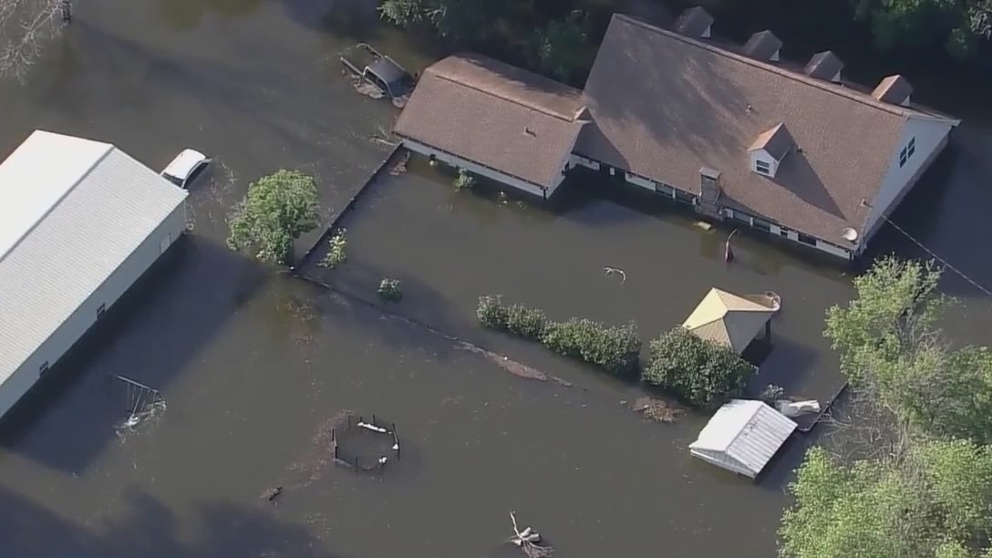
Ongoing flooding in Florida and hurricane recovery
Mike Iscovitz and John Dawson are joined by FOX's Bowen Kedrowicz who is in Land O' Lakes, Florida with a look at the ongoing flooding in the area and continuous recovery efforts.
Mike Iscovitz and John Dawson are joined by FOX's Bowen Kedrowicz who is in Land O' Lakes, Florida with a look at the ongoing flooding in the area and continuous recovery efforts.


Family that lost 11 in Hurricane Helene mudslides says community sacrificed 'life and limb' to save each other
The Craig family has lived in a North Carolina community, dubbed 'Craigtown' by locals, for 80 years.
The Craig family has lived in a North Carolina community, dubbed 'Craigtown' by locals, for 80 years.
More than 90 people still missing in North Carolina after Hurricane Helene
As North Carolina continues to grapple with the devastation left behind by Hurricane Helene, at least 92 people are still missing.
As North Carolina continues to grapple with the devastation left behind by Hurricane Helene, at least 92 people are still missing.

FOX 26 Houston Weather Forecast
Wow! After a couple of record shattering, very hot days, a cold front has arrived. Look for a windy, very dry day with afternoon temperatures at least 20 degrees cooler then yesterday. Clear skies and drier air should bring us the coolest weather in more than six months tonight area wide - bona fide brisk! The rest of the week is looking terrific, but you should notice a bit more humidity and warmer air by early next week. One issue to be aware of is that we are dry - very dry, and with wind and low humidity, there is a fire risk today. Most local counties are under declared burn bans, so avoid anything that could set dry grass or brush on fire. There are a couple of possible developments in the tropics, but neither is a concern for our area at this point. Enjoy the chilly air!
Wow! After a couple of record shattering, very hot days, a cold front has arrived. Look for a windy, very dry day with afternoon temperatures at least 20 degrees cooler then yesterday. Clear skies and drier air should bring us the coolest weather in more than six months tonight area wide - bona fide brisk! The rest of the week is looking terrific, but you should notice a bit more humidity and warmer air by early next week. One issue to be aware of is that we are dry - very dry, and with wind and low humidity, there is a fire risk today. Most local counties are under declared burn bans, so avoid anything that could set dry grass or brush on fire. There are a couple of possible developments in the tropics, but neither is a concern for our area at this point. Enjoy the chilly air!

FOX 26 Houston Weather Forecast
A change is finally coming! Thanks to a cold front tonight, we are back to fall weather Wednesday and Thursday! We set another record high in Houston(Bush) today soaring to 98 degrees! Previous record was 92 in 2019. That should be an end to the record heat for awhile as temperatures drop about 20 degrees Wednesday! Look for high temperatures in the 70s tomorrow with overnight lows in 40s and 50s Wednesday night. As southerly flow returns this weekend, moisture increases a bit although rain chances will only be at 10%. Download Fox Local now available for your phone and smart tv for even more weather coverage and exclusives!
A change is finally coming! Thanks to a cold front tonight, we are back to fall weather Wednesday and Thursday! We set another record high in Houston(Bush) today soaring to 98 degrees! Previous record was 92 in 2019. That should be an end to the record heat for awhile as temperatures drop about 20 degrees Wednesday! Look for high temperatures in the 70s tomorrow with overnight lows in 40s and 50s Wednesday night. As southerly flow returns this weekend, moisture increases a bit although rain chances will only be at 10%. Download Fox Local now available for your phone and smart tv for even more weather coverage and exclusives!


SBA halts disaster loans after Hurricanes Helene, Milton as funding runs dry
The Small Business Administration has paused new disaster loans due to a funding shortfall caused by Hurricanes Helene and Milton, delaying aid for small businesses, homeowners, and renters. FEMA aid remains available.
The Small Business Administration has paused new disaster loans due to a funding shortfall caused by Hurricanes Helene and Milton, delaying aid for small businesses, homeowners, and renters. FEMA aid remains available.

FOX 26 Houston Weather Forecast
FOX 26 Meteorologist Remeisha Shade has more on the cooler weather moving into the Bayou City for Wednesday!
FOX 26 Meteorologist Remeisha Shade has more on the cooler weather moving into the Bayou City for Wednesday!

Monitoring areas of development in Atlantic | FOX 26 Houston Tropical Weather Forecast
There are still two areas of concern we are closely monitoring in the Atlantic basin. The first, Invest 94-L, has a MEDIUM 50% chance for development into our next tropical system which would be Nadine. It could reach the Lesser Antilles by this weekend as it moves west. Another broad area of low pressure is being monitored in the western Caribbean near Central America. If this disturbance remains over water, there's a low 20% chance it could strengten to a tropical depression or tropical storm. However, landfall would most likely be around Mexico and Central America. Download FOX Local app on your phone or smart tv for daily detailed tropical updates and more!
There are still two areas of concern we are closely monitoring in the Atlantic basin. The first, Invest 94-L, has a MEDIUM 50% chance for development into our next tropical system which would be Nadine. It could reach the Lesser Antilles by this weekend as it moves west. Another broad area of low pressure is being monitored in the western Caribbean near Central America. If this disturbance remains over water, there's a low 20% chance it could strengten to a tropical depression or tropical storm. However, landfall would most likely be around Mexico and Central America. Download FOX Local app on your phone or smart tv for daily detailed tropical updates and more!
Fire suppression kit and farmer's market visit!
John Dawson and Allison Gargaro do a live gear test of a fire suppression kit. Also, Allison gives a look around Houston Farmer's Market!
John Dawson and Allison Gargaro do a live gear test of a fire suppression kit. Also, Allison gives a look around Houston Farmer's Market!

Houston SPCA to help with pets in Florida
A rescue mission is underway as the Houston SPCA heads to Florida to collect soem of the pets rescued in Florida after Hurricane Milton. FOX 26's Shelby Rose has mroe as volunteers loaded up for the journey.
A rescue mission is underway as the Houston SPCA heads to Florida to collect soem of the pets rescued in Florida after Hurricane Milton. FOX 26's Shelby Rose has mroe as volunteers loaded up for the journey.

FOX 26 Houston Weather Forecast
Record heat is likely again today as afternoon highs will soar to the mid and upper-90s. Houston is under an Air Quality Alert again today. A dry cold front moves across southeast Texas overnight. In its wake, afternoon highs on Wednesday and Thursday will be in the 70s. Wake up temperatures by Thursday morning will be dipping into the 50s in Houston and even 40s north of town. Humidity will be back on the rise this weekend with the return of the 80s.
Record heat is likely again today as afternoon highs will soar to the mid and upper-90s. Houston is under an Air Quality Alert again today. A dry cold front moves across southeast Texas overnight. In its wake, afternoon highs on Wednesday and Thursday will be in the 70s. Wake up temperatures by Thursday morning will be dipping into the 50s in Houston and even 40s north of town. Humidity will be back on the rise this weekend with the return of the 80s.

FOX 26 Houston Weather Forecast
Air Quality Alert has been extended through Tuesday evening with higher ozone levels expected. Reduce time outside if you have respiratory issues. Otherwise, get ready for one more day with record heat before a cold front brings some relief. High temperatures will soar to the middle to upper 90s Tuesday with plenty of sun. So get ready for more record high temperatures to be set Tuesday. By late Wednesday, cold front rolls in to bring more fall-like weather for the rest of the week. Slim rain chances return this weekend. Keep up with all the latest weather by downloading our FOX Local app on your phone or smart tv... and remember... it's Free!
Air Quality Alert has been extended through Tuesday evening with higher ozone levels expected. Reduce time outside if you have respiratory issues. Otherwise, get ready for one more day with record heat before a cold front brings some relief. High temperatures will soar to the middle to upper 90s Tuesday with plenty of sun. So get ready for more record high temperatures to be set Tuesday. By late Wednesday, cold front rolls in to bring more fall-like weather for the rest of the week. Slim rain chances return this weekend. Keep up with all the latest weather by downloading our FOX Local app on your phone or smart tv... and remember... it's Free!