


FOX 26 Houston Weather Forecast
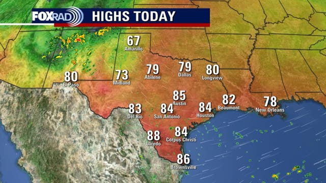
Weather for early voting and any other errands you may have planned should continue to be fairly quiet. Temperatures are heating up as we move farther away from the taste of fall weather we enjoyed last week with Houston dipping to the 40s! Look for highs near 90 the rest of this week with only a very slim 10% rain chance. Houston has moved back to moderate drought and this will likely get worse with no significant rain in sight. In the Atlantic basin, Tropical Storm Oscar is still sitting over eastern Cuba and will pass over the SE Bahamas over the next 24 hours. It is expected to turn NE and stay away from the U.S. Get all the weather info you want or need by downloading FOX Local, now for your phone AND smart TV! Download it today!
Weather for early voting and any other errands you may have planned should continue to be fairly quiet. Temperatures are heating up as we move farther away from the taste of fall weather we enjoyed last week with Houston dipping to the 40s! Look for highs near 90 the rest of this week with only a very slim 10% rain chance. Houston has moved back to moderate drought and this will likely get worse with no significant rain in sight. In the Atlantic basin, Tropical Storm Oscar is still sitting over eastern Cuba and will pass over the SE Bahamas over the next 24 hours. It is expected to turn NE and stay away from the U.S. Get all the weather info you want or need by downloading FOX Local, now for your phone AND smart TV! Download it today!

FOX 26 Houston Weather Forecast
Weather for early voting and any other errands you may have planned should continue to be fairly quiet. Temperatures are heating up as we move farther away from the taste of fall weather we enjoyed last week with Houston dipping to the 40s! Look for highs near 90 the rest of this week with only a very slim 10% rain chance. Houston has moved back to moderate drought and this will likely get worse with no significant rain in sight. In the Atlantic basin, Tropical Storm Oscar is still sitting over eastern Cuba and will pass over the SE Bahamas over the next 24 hours. It is expected to turn NE and stay away from the U.S. Get all the weather info you want or need by downloading FOX Local, now for your phone AND smart tv! Disclosed it today!
Weather for early voting and any other errands you may have planned should continue to be fairly quiet. Temperatures are heating up as we move farther away from the taste of fall weather we enjoyed last week with Houston dipping to the 40s! Look for highs near 90 the rest of this week with only a very slim 10% rain chance. Houston has moved back to moderate drought and this will likely get worse with no significant rain in sight. In the Atlantic basin, Tropical Storm Oscar is still sitting over eastern Cuba and will pass over the SE Bahamas over the next 24 hours. It is expected to turn NE and stay away from the U.S. Get all the weather info you want or need by downloading FOX Local, now for your phone AND smart tv! Disclosed it today!

Watching Kristy, Oscar | FOX 26 Tropical Weather Forecast
It was a busy weekend in the tropics with Tropical Storm Nadine popping up in the NW Caribbean & quickly making landfall in Belize. The remnants of Nadine pushed into the eastern Pacific reorganizing into what is now Tropical Storm Kristy. Kristy is forecast to become a Category 2 hurricane later this week but will be moving west away from Mexico and the U.S. Oscar also formed in the Atlantic and quickly grew to a hurricane hitting parts of Cuba. Oscar has weakened to a tropical storm today over eastern Cuba and is expected to make a turn N then NE taking it towards the SE Bahamas. It will then move NE away from the U.S. the next few days before being absorbed by a non-tropical low later this week. Hurricane season runs through November 30th.
It was a busy weekend in the tropics with Tropical Storm Nadine popping up in the NW Caribbean & quickly making landfall in Belize. The remnants of Nadine pushed into the eastern Pacific reorganizing into what is now Tropical Storm Kristy. Kristy is forecast to become a Category 2 hurricane later this week but will be moving west away from Mexico and the U.S. Oscar also formed in the Atlantic and quickly grew to a hurricane hitting parts of Cuba. Oscar has weakened to a tropical storm today over eastern Cuba and is expected to make a turn N then NE taking it towards the SE Bahamas. It will then move NE away from the U.S. the next few days before being absorbed by a non-tropical low later this week. Hurricane season runs through November 30th.

Hurricane Gear Test: Champion Tri Fuel Inverter Generator
An emergency can happen any time, so you might be thinking about getting a generator. Meteorologist John Dawson talks about what to consider before making that big purchase and takes a look at the Champion Tri Fuel Inverter Generator.
An emergency can happen any time, so you might be thinking about getting a generator. Meteorologist John Dawson talks about what to consider before making that big purchase and takes a look at the Champion Tri Fuel Inverter Generator.

FOX 26 Houston weather: Oct. 21 morning forecast
Welcome to a beautiful Monday. After an awesome weekend, the trend will continue today with pleasant humidity levels, sunshine and highs in the mid 80s. For the rest of the week, humidity and temperatures should gradually increase with upper 80s and even a few low 90s possible. We need some rain. Most locations have not received rain this month and many only had sparse rainfall in September, so drought conditions are spreading and the outlook for rain over the next 7 days looks dry. In the tropics, it was a busy weekend with Tropical Storm Nadine making landfall in Belize and a quickly forming Hurricane Oscar impacting the Southern Bahamas and Cuba. No systems are a threat to Texas.
Welcome to a beautiful Monday. After an awesome weekend, the trend will continue today with pleasant humidity levels, sunshine and highs in the mid 80s. For the rest of the week, humidity and temperatures should gradually increase with upper 80s and even a few low 90s possible. We need some rain. Most locations have not received rain this month and many only had sparse rainfall in September, so drought conditions are spreading and the outlook for rain over the next 7 days looks dry. In the tropics, it was a busy weekend with Tropical Storm Nadine making landfall in Belize and a quickly forming Hurricane Oscar impacting the Southern Bahamas and Cuba. No systems are a threat to Texas.

Hurricane Oscar makes second landfall in Cuba on Sunday after slamming Bahamas as Category 1
Hurricane Oscar maintained Category 1 strength as the small hurricane made a second landfall in Cuba Sunday evening.
Hurricane Oscar maintained Category 1 strength as the small hurricane made a second landfall in Cuba Sunday evening.

FOX 26 Houston weather: Oct. 20 evening forecast
More pleasant October days expected this week as Southeast Texas experiences no weather systems moving into the region. That quiet pattern is certainly nice but it also means no rain, and areas around Houston are starting to show that lack of rain. Humidity and temperatures will slowly increase during the week with 90s expected for the afternoon highs at the end of the week.
More pleasant October days expected this week as Southeast Texas experiences no weather systems moving into the region. That quiet pattern is certainly nice but it also means no rain, and areas around Houston are starting to show that lack of rain. Humidity and temperatures will slowly increase during the week with 90s expected for the afternoon highs at the end of the week.

Tracking Hurricane Oscar | Tropical Weather Forecast
Hurricane Oscar is heading toward Cuba. FOX 26 meteorologist John Dawson takes a look at the storm's track and what is left of what was once Tropical Storm Nadine.
Hurricane Oscar is heading toward Cuba. FOX 26 meteorologist John Dawson takes a look at the storm's track and what is left of what was once Tropical Storm Nadine.

FOX 26 Houston weather: Oct. 20 morning forecast
FOX 26 meteorologist Mike Iscovitz takes a look at the weather across the region and gives an update on a bit of tropical activity.
FOX 26 meteorologist Mike Iscovitz takes a look at the weather across the region and gives an update on a bit of tropical activity.

Tracking Hurricane Oscar, Tropical Storm Nadine
FOX 26 meteorologist John Dawson gives an update on Tropical Storm Nadine, which is bringing flooding to the Western Caribbean, and Hurricane Oscar which is impacting Turks and Caicos and the Bahamas before heading to Cuba.
FOX 26 meteorologist John Dawson gives an update on Tropical Storm Nadine, which is bringing flooding to the Western Caribbean, and Hurricane Oscar which is impacting Turks and Caicos and the Bahamas before heading to Cuba.

Houston weather: Beautiful weekend ahead in Houston, Tropical Storm Nadine forms
We'll enjoy mostly sunny and slightly breezy weather along with temperatures that are just slightly above average for mid-October.
We'll enjoy mostly sunny and slightly breezy weather along with temperatures that are just slightly above average for mid-October.

FOX 26 Houston Weather: Oct. 19 morning forecast
FOX 26's Mike Iscovitz takes a look at a nice weekend in Houston and newly-formed Tropical Storm Nadine.
FOX 26's Mike Iscovitz takes a look at a nice weekend in Houston and newly-formed Tropical Storm Nadine.

FOX 26 Weather Forecast
Fairly quiet and seasonal weather is expected for your weekend outdoor plans. However, if you're heading to Galveston Beach, it's breezy & there's a high risk for rip currents and a coastal flood advisory through Saturday morning. Minor flooding is possible, especially during times of high tides. Otherwise mostly sunny and dry weather is expected this weekend. Rain chances are only around 10% as we go through next week. It will get warmer with temperatures climbing back to near 90 by the middle of next week. Invest 94-L near Puerto Rico only has a Low 20% chance for tropical development. Invest 95-L, now Potential Tropical Cyclone 15, is expected to make landfall in Central America near Belize and Southern Mexico this weekend. But before it does, it could become a tropical depression or storm briefly. Next name on the list is Nadine. Neither of these systems is expected to impact the Houston area. Download the FOX Local app for your smart tv and now for your phone for lots or original Fox26 content and all our Live newscasts!
Fairly quiet and seasonal weather is expected for your weekend outdoor plans. However, if you're heading to Galveston Beach, it's breezy & there's a high risk for rip currents and a coastal flood advisory through Saturday morning. Minor flooding is possible, especially during times of high tides. Otherwise mostly sunny and dry weather is expected this weekend. Rain chances are only around 10% as we go through next week. It will get warmer with temperatures climbing back to near 90 by the middle of next week. Invest 94-L near Puerto Rico only has a Low 20% chance for tropical development. Invest 95-L, now Potential Tropical Cyclone 15, is expected to make landfall in Central America near Belize and Southern Mexico this weekend. But before it does, it could become a tropical depression or storm briefly. Next name on the list is Nadine. Neither of these systems is expected to impact the Houston area. Download the FOX Local app for your smart tv and now for your phone for lots or original Fox26 content and all our Live newscasts!

FOX 26 Houston Weather Forecast
Fairly quiet and seasonal weather is expected for your weekend outdoor plans. However, if you're heading to Galveston Beach, it's breezy & there's a high risk for rip currents and a coastal flood advisory through Saturday morning. Minor flooding is possible, especially during times of high tides. Otherwise mostly sunny and dry weather is expected this weekend. Rain chances are only around 10% as we go through next week. It will get warmer with temperatures climbing back to near 90 by the middle of next week. Invest 94-L near Puerto Rico only has a Low 20% chance for tropical development. Invest 95-L, now Potential Tropical Cyclone 15, is expected to make landfall in Central America near Belize and Southern Mexico this weekend. But before it does, it could become a tropical depression or storm briefly. Next name on the list is Nadine. Neither of these systems is expected to impact the Houston area. Download the FOX Local app for your smart tv and now for your phone for lots or original Fox26 content and all our Live newscasts!
Fairly quiet and seasonal weather is expected for your weekend outdoor plans. However, if you're heading to Galveston Beach, it's breezy & there's a high risk for rip currents and a coastal flood advisory through Saturday morning. Minor flooding is possible, especially during times of high tides. Otherwise mostly sunny and dry weather is expected this weekend. Rain chances are only around 10% as we go through next week. It will get warmer with temperatures climbing back to near 90 by the middle of next week. Invest 94-L near Puerto Rico only has a Low 20% chance for tropical development. Invest 95-L, now Potential Tropical Cyclone 15, is expected to make landfall in Central America near Belize and Southern Mexico this weekend. But before it does, it could become a tropical depression or storm briefly. Next name on the list is Nadine. Neither of these systems is expected to impact the Houston area. Download the FOX Local app for your smart tv and now for your phone for lots or original Fox26 content and all our Live newscasts!

Continuing to monitor 2 disturbances in Atlantic Basin | FOX 26 Tropical Weather Update
We are still monitoring two disturbances in the Atlantic basin. Invest 95-L in the western Caribbean is now Potential Tropical Cyclone 15 with a HIGH 70% chance to become a brief tropical depression or tropical storm Nadine. PTC 15 is already very close to land & should move inland over Belize in Central America and Southern Mexico this weekend. Invest 94-L is just north of Puerto Rico and the Virgin Islands with just a Low 20% shot to become a tropical system over the next 2-7 days. By early next week, upper level winds will become unfavorable for tropical development. This disturbance will likely dissipate at that time. Hurricane season runs through November 30th.
We are still monitoring two disturbances in the Atlantic basin. Invest 95-L in the western Caribbean is now Potential Tropical Cyclone 15 with a HIGH 70% chance to become a brief tropical depression or tropical storm Nadine. PTC 15 is already very close to land & should move inland over Belize in Central America and Southern Mexico this weekend. Invest 94-L is just north of Puerto Rico and the Virgin Islands with just a Low 20% shot to become a tropical system over the next 2-7 days. By early next week, upper level winds will become unfavorable for tropical development. This disturbance will likely dissipate at that time. Hurricane season runs through November 30th.

Energy Day Houston Festival | Forecasting With Friends
Mike Iscovitz and Remeisha Shade take a look at the weather in the Houston area for this weekend and the week ahead., plus the Energy Day Houston Festival is this weekend. David Holt, the president of the Consumer Energy Alliance talks about the event.
Mike Iscovitz and Remeisha Shade take a look at the weather in the Houston area for this weekend and the week ahead., plus the Energy Day Houston Festival is this weekend. David Holt, the president of the Consumer Energy Alliance talks about the event.

FOX 26 Weather: Oct. 18 late morning forecast
Fall feeling weather will stay with us for another day or two, but the overall trend will be toward gradually warmer and more humid air over the next several days. For example, today's average high temperature is 82 degrees and we will likely remain just below that this afternoon. We are back in a moderate drought and very little rain is on the way for the next week or two. Other than an occasional small shower, nothing significant is expected, so area vegetation and soil will get even crunchier.
Fall feeling weather will stay with us for another day or two, but the overall trend will be toward gradually warmer and more humid air over the next several days. For example, today's average high temperature is 82 degrees and we will likely remain just below that this afternoon. We are back in a moderate drought and very little rain is on the way for the next week or two. Other than an occasional small shower, nothing significant is expected, so area vegetation and soil will get even crunchier.

FOX 26 Houston Weather: Oct. 18 morning forecast
It's a cool Friday morning, but changes in the forecast are coming next week. FOX 26's Mike Iscovitz takes a look at just how warm it is expected to get.
It's a cool Friday morning, but changes in the forecast are coming next week. FOX 26's Mike Iscovitz takes a look at just how warm it is expected to get.

FOX 26 Houston Weather Forecast
Beautiful fall weather will continue for the rest of this week ! Get ready for another cool night with temperatures in the 50s in Houston with some 40s possible north. A gradual warming trend begins Friday and lasts through much of next week. In fact, temperatures are back up to near 90 by Tuesday, Wednesday & Thursday. A bit of low-level moisture returns by this weekend which will lead to at least a 10% rain chances. Fox Local is now available on your phone and smart tv! Find live Fox 26 news, weather & special features! Download it today!
Beautiful fall weather will continue for the rest of this week ! Get ready for another cool night with temperatures in the 50s in Houston with some 40s possible north. A gradual warming trend begins Friday and lasts through much of next week. In fact, temperatures are back up to near 90 by Tuesday, Wednesday & Thursday. A bit of low-level moisture returns by this weekend which will lead to at least a 10% rain chances. Fox Local is now available on your phone and smart tv! Find live Fox 26 news, weather & special features! Download it today!

FOX 26 Houston Weather Forecast
Beautiful fall weather will continue for the rest of this week! Get ready for another cool night with temperatures in the 50s in Houston with some 40s possible north. A gradual warming trend begins Friday and lasts through much of next week. In fact, temperatures are back up to near 90 by Tuesday, Wednesday & Thursday. A bit of low-level moisture returns by this weekend which will lead to at least a 10% rain chances. Fox Local is now available on your phone and smart tv! Find live Fox 26 news, weather & special features! Download it today!
Beautiful fall weather will continue for the rest of this week! Get ready for another cool night with temperatures in the 50s in Houston with some 40s possible north. A gradual warming trend begins Friday and lasts through much of next week. In fact, temperatures are back up to near 90 by Tuesday, Wednesday & Thursday. A bit of low-level moisture returns by this weekend which will lead to at least a 10% rain chances. Fox Local is now available on your phone and smart tv! Find live Fox 26 news, weather & special features! Download it today!