


Houston Weather: Scattered showers, storms with near-normal temperatures most of the week
Overall a pleasant forecast for the last week of May in Houston. There will be a few scattered showers and storms with near-normal temperatures for most of the week. Slightly higher chances for rain on Wednesday afternoon and right now the holiday weekend is looking mostly dry.
Overall a pleasant forecast for the last week of May in Houston. There will be a few scattered showers and storms with near-normal temperatures for most of the week. Slightly higher chances for rain on Wednesday afternoon and right now the holiday weekend is looking mostly dry.

Houston Weather: Temps in the mid-80s with isolated afternoon showers possible
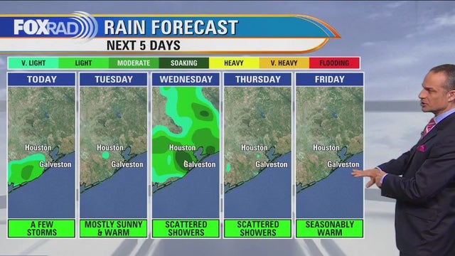
We have a pretty nice-looking week ahead with a few scattered storms and near-normal temperatures. Expect highs today to run slightly below normal (average high is 89�) with some isolated storms for our coastal counties. Tuesday looks warmer with highs near 90 followed by scattered storms Wednesday. An area of low-pressure east of the Bahamas has a slight chance of becoming a tropical depression this week, but it would have no effect on land and is very far from Texas.
We have a pretty nice-looking week ahead with a few scattered storms and near-normal temperatures. Expect highs today to run slightly below normal (average high is 89�) with some isolated storms for our coastal counties. Tuesday looks warmer with highs near 90 followed by scattered storms Wednesday. An area of low-pressure east of the Bahamas has a slight chance of becoming a tropical depression this week, but it would have no effect on land and is very far from Texas.

Houston Weather: Possibility for isolated storms Monday evening with highs in the mid 80s
We have a pretty nice-looking week ahead with a few scattered storms and near normal temperatures. Expect highs today to run slightly below normal (average high is 89°) with some isolated storms for our coastal counties. Tuesday looks warmer with highs near 90 followed by scattered storms Wednesday. An area of low pressure east of the Bahamas has a slight chance of becoming a tropical depression this week, but it would have no effect on land and is very far from Texas.
We have a pretty nice-looking week ahead with a few scattered storms and near normal temperatures. Expect highs today to run slightly below normal (average high is 89°) with some isolated storms for our coastal counties. Tuesday looks warmer with highs near 90 followed by scattered storms Wednesday. An area of low pressure east of the Bahamas has a slight chance of becoming a tropical depression this week, but it would have no effect on land and is very far from Texas.

Possibility for isolated storms Monday evening with highs in the mid 80s
Warm hot weather for the rest of the week as isolated showers are expected for Monday evening.
Warm hot weather for the rest of the week as isolated showers are expected for Monday evening.

Houston weather: Warm Monday with isolated afternoon storms possible.
We have a pretty nice-looking week ahead with a few scattered storms and near normal temperatures. Expect highs today to run slightly below normal (average high is 89?) with some isolated storms for our coastal counties. Tuesday looks warmer with highs near 90 followed by scattered storms Wednesday. An area of low pressure east of the Bahamas has a slight chance of becoming a tropical depression this week, but it would have no effect on land and is very far from Texas.
We have a pretty nice-looking week ahead with a few scattered storms and near normal temperatures. Expect highs today to run slightly below normal (average high is 89?) with some isolated storms for our coastal counties. Tuesday looks warmer with highs near 90 followed by scattered storms Wednesday. An area of low pressure east of the Bahamas has a slight chance of becoming a tropical depression this week, but it would have no effect on land and is very far from Texas.

Houston weather: Mild, warm temperatures going into work week and chances for rain Wednesday
It's looking like a typical end of May across Southeast Texas this week. Temperatures start a bit mild on Monday but will slowly warm during the week. Slightly higher rain chances on Wednesday afternoon across Houston. Next weekend is looking warm and dry for now.
It's looking like a typical end of May across Southeast Texas this week. Temperatures start a bit mild on Monday but will slowly warm during the week. Slightly higher rain chances on Wednesday afternoon across Houston. Next weekend is looking warm and dry for now.

Houston weather: Cloudy, yet warm Sunday evening in the 80s
It's looking like a typical end of May across Southeast Texas this week. Temperatures start a bit mild on Monday but will slowly warm during the week. Slightly higher rain chances on Wednesday afternoon across Houston. Next weekend is looking warm and dry for now.
It's looking like a typical end of May across Southeast Texas this week. Temperatures start a bit mild on Monday but will slowly warm during the week. Slightly higher rain chances on Wednesday afternoon across Houston. Next weekend is looking warm and dry for now.

Gloomy but cool Sunday, work week will warm up as sun returns with rain chances
We're in for a bit of a gloomy Sunday with cloud-dominant skies and a few light to moderate showers. After a cooler Sunday, we'll warm things up at the start of the work week as the sun returns with slim rain chances. Be on the lookout for a few downpours and storms Wednesday afternoon and evening. We are trending dry, and warm as we head into Memorial Day Weekend locally.
We're in for a bit of a gloomy Sunday with cloud-dominant skies and a few light to moderate showers. After a cooler Sunday, we'll warm things up at the start of the work week as the sun returns with slim rain chances. Be on the lookout for a few downpours and storms Wednesday afternoon and evening. We are trending dry, and warm as we head into Memorial Day Weekend locally.

Warm, mostly cloudy Saturday evening in the 80s
Southeast Texas will keep some chances for rain each day, but overall a quiet forecast for the rest of the weekend and the start of next week. Memorial Day Weekend is looking mostly dry for now and temperatures should be about normal for Houston.
Southeast Texas will keep some chances for rain each day, but overall a quiet forecast for the rest of the weekend and the start of next week. Memorial Day Weekend is looking mostly dry for now and temperatures should be about normal for Houston.

Houston Weather: Quiet week with average temps, low rain chances
We're in for a mostly quiet week with temperatures hovering near average and low rain chances. Each day features at least the possibility of an isolated shower or storm and mornings will be a bit muggy at times. Memorial Day Weekend is in sight and Friday is looking toasty. Right now we look to stay dry and warm through the holiday.
We're in for a mostly quiet week with temperatures hovering near average and low rain chances. Each day features at least the possibility of an isolated shower or storm and mornings will be a bit muggy at times. Memorial Day Weekend is in sight and Friday is looking toasty. Right now we look to stay dry and warm through the holiday.

Houston weather: Partly sunny, few showers possible on Saturday
We are rolling into the weekend with no widespread bad weather expected. That means just a few showers and storms possible as a weak front arrives Saturday evening. Temperatures will be toasty again Saturday near 90 but cooler in the low 80s Sunday behind that front. Look for only a 20% chance for isolated heavy downpours this weekend with even lower rain chances Monday. A few more storms may pop up Tuesday and Wednesday with temperatures once again climbing to near 90. But we are now entering late May so that is typical for this time of the year.
We are rolling into the weekend with no widespread bad weather expected. That means just a few showers and storms possible as a weak front arrives Saturday evening. Temperatures will be toasty again Saturday near 90 but cooler in the low 80s Sunday behind that front. Look for only a 20% chance for isolated heavy downpours this weekend with even lower rain chances Monday. A few more storms may pop up Tuesday and Wednesday with temperatures once again climbing to near 90. But we are now entering late May so that is typical for this time of the year.

Houston weather: Plenty of sunshine Friday evening, few possible storms this weekend
We are rolling into the weekend with no widespread bad weather expected. That means just a few showers and storms possible as a weak front arrives Saturday evening. Temperatures will be toasty again Saturday near 90 but cooler in the low 80s Sunday behind that front. Look for only a 20% chance for isolated heavy downpours this weekend with even lower rain chances Monday. A few more storms may pop up Tuesday and Wednesday with temperatures once again climbing to near 90. But we are now entering late May so that is typical for this time of the year. Have a great weekend and make sure you check out our FOX 26 Weather App that you can download from the app store!
We are rolling into the weekend with no widespread bad weather expected. That means just a few showers and storms possible as a weak front arrives Saturday evening. Temperatures will be toasty again Saturday near 90 but cooler in the low 80s Sunday behind that front. Look for only a 20% chance for isolated heavy downpours this weekend with even lower rain chances Monday. A few more storms may pop up Tuesday and Wednesday with temperatures once again climbing to near 90. But we are now entering late May so that is typical for this time of the year. Have a great weekend and make sure you check out our FOX 26 Weather App that you can download from the app store!

Houston weather: Sunny, hot Friday afternoon in the upper 80s
After several sunny, hot days our air quality has been impacted and in addition to ozone some light wildfire smoke may get carried in from the north with an approaching front. Sensitive groups or those with respiratory illnesses may want to consider limiting time outside if bothersome. Aside from an increase in cloud cover as that boundary progresses, we look to make it through the weekend with only isolated rain. Generally quiet weather looks to continue for much of next week.
After several sunny, hot days our air quality has been impacted and in addition to ozone some light wildfire smoke may get carried in from the north with an approaching front. Sensitive groups or those with respiratory illnesses may want to consider limiting time outside if bothersome. Aside from an increase in cloud cover as that boundary progresses, we look to make it through the weekend with only isolated rain. Generally quiet weather looks to continue for much of next week.

Houston weather: Mostly sunny and hot Friday
Following a sunny, hot Thursday, today will be a repeat and possibly slightly warmer. Look for highs in the low 90s with a very slight chance for a late-day storm. Overnight, storms could affect areas well northwest of Houston. The weekend looks OK with scattered showers possible and highs in the mid 80s.
Following a sunny, hot Thursday, today will be a repeat and possibly slightly warmer. Look for highs in the low 90s with a very slight chance for a late-day storm. Overnight, storms could affect areas well northwest of Houston. The weekend looks OK with scattered showers possible and highs in the mid 80s.

Houston weather: Hottest day of the week on Friday, rain chances possible Saturday
Friday will likely be the hottest day of the week with temps near 92 degrees for the Houston area and heat index values near 100 degrees for some. Take it easy in the heat and keep in mind that an air quality alert for ozone will once again be in effect. Rain chances increase a bit Saturday as a weak cold front rolls in from the north. But we are still just talking about a 30% chance for rain Saturday and Sunday. Next week will feature more typical May weather with seasonable temperatures and small chances for rain.
Friday will likely be the hottest day of the week with temps near 92 degrees for the Houston area and heat index values near 100 degrees for some. Take it easy in the heat and keep in mind that an air quality alert for ozone will once again be in effect. Rain chances increase a bit Saturday as a weak cold front rolls in from the north. But we are still just talking about a 30% chance for rain Saturday and Sunday. Next week will feature more typical May weather with seasonable temperatures and small chances for rain.

Houston weather: Plenty of heat, humidity Thursday evening in the 80s
Weather tonight should be warm but mainly dry with rain chances less than 10%. Temperatures should dip to near 70 overnight with just a few clouds. Friday will likely be the hottest day of the week with temps near 92 for the Houston area and heat index values near 100 for some. Take it easy in the heat and keep in mind that an air quality alert for ozone will once again be in effect. Rain chances increase a bit Saturday as a weak cold front rolls in from the north. But we are still just talking about a 30% chance for rain Saturday and Sunday. Next week will feature more typical May weather with seasonable temperatures and small chances for rain. Grab our FOX 26 Weather App to keep track of all the latest weather changes!
Weather tonight should be warm but mainly dry with rain chances less than 10%. Temperatures should dip to near 70 overnight with just a few clouds. Friday will likely be the hottest day of the week with temps near 92 for the Houston area and heat index values near 100 for some. Take it easy in the heat and keep in mind that an air quality alert for ozone will once again be in effect. Rain chances increase a bit Saturday as a weak cold front rolls in from the north. But we are still just talking about a 30% chance for rain Saturday and Sunday. Next week will feature more typical May weather with seasonable temperatures and small chances for rain. Grab our FOX 26 Weather App to keep track of all the latest weather changes!

Houston weather: Sunny, dry Thursday afternoon with temps in 80s
We'll close out the work week with more sunny, dry, warm days and another Ozone Action Day in effect for Thursday. A cold front brings a chance of strong to severe storms and more drought relief well northwest of here over the next few days, meanwhile we'll see an increase in weekend cloud cover and only isolated to scattered rain chances. We've kicked the drought to the curb completely with all of our early month rain. Outdoor graduations over the next few days and the weekend should be mostly fine but keep an eye on things through the FOX 26 weather app.
We'll close out the work week with more sunny, dry, warm days and another Ozone Action Day in effect for Thursday. A cold front brings a chance of strong to severe storms and more drought relief well northwest of here over the next few days, meanwhile we'll see an increase in weekend cloud cover and only isolated to scattered rain chances. We've kicked the drought to the curb completely with all of our early month rain. Outdoor graduations over the next few days and the weekend should be mostly fine but keep an eye on things through the FOX 26 weather app.

Houston weather: Mostly sunny Thursday with highs near 90
We're going to see Day 2 of sunshine and much needed relief from recent flooding. Look for a warm, sunny day today and tomorrow with highs close to 90. This weekend, scattered showers and a few storms are possible, but it doesn't look like a flood threat. Next week features pretty typical late May weather.
We're going to see Day 2 of sunshine and much needed relief from recent flooding. Look for a warm, sunny day today and tomorrow with highs close to 90. This weekend, scattered showers and a few storms are possible, but it doesn't look like a flood threat. Next week features pretty typical late May weather.

Houston weather: Mild Thursday morning, then mostly sunny with highs near 90
We're going to see Day 2 of sunshine and much needed relief from recent flooding. Look for a warm, sunny day today and tomorrow with highs close to 90. This weekend, scattered showers and a few storms are possible, but it doesn't look like a flood threat. Next week features pretty typical late May weather.
We're going to see Day 2 of sunshine and much needed relief from recent flooding. Look for a warm, sunny day today and tomorrow with highs close to 90. This weekend, scattered showers and a few storms are possible, but it doesn't look like a flood threat. Next week features pretty typical late May weather.

Mild morning, then mostly sunny with highs near 90
We're going to see Day 2 of sunshine and much needed relief from recent flooding. Look for a warm, sunny day today and tomorrow with highs close to 90. This weekend, scattered showers and a few storms are possible, but it doesn't look like a flood threat. Next week features pretty typical late May weather.
We're going to see Day 2 of sunshine and much needed relief from recent flooding. Look for a warm, sunny day today and tomorrow with highs close to 90. This weekend, scattered showers and a few storms are possible, but it doesn't look like a flood threat. Next week features pretty typical late May weather.