

Thursday morning weather forecast
It will be cool in the morning hours for the next couple of days and the afternoons look rather pleasant. Humidity will start to return by the end of the weekend and rain will be back in the forecast by later on Monday.
It will be cool in the morning hours for the next couple of days and the afternoons look rather pleasant. Humidity will start to return by the end of the weekend and rain will be back in the forecast by later on Monday.
Wednesday Evening Weather Forecast
It will be cool in the morning hours for the next couple of days and the afternoons look rather pleasant. Humidity will start to return by the end of the weekend and rain will be back in the forecast by later on Monday.
It will be cool in the morning hours for the next couple of days and the afternoons look rather pleasant. Humidity will start to return by the end of the weekend and rain will be back in the forecast by later on Monday.
Wednesday weather forecast
Sunny, windy and dry with morning temperatures in the 60s and highs in the mid 80s.
Sunny, windy and dry with morning temperatures in the 60s and highs in the mid 80s.
Tuesday night leading into Wednesday morning weather forecast
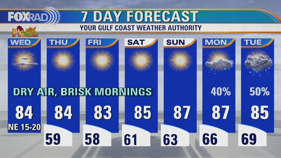
Fall arrives on Wednesday and it will feel like it thanks to a cool front pushing out into the Gulf of Mexico. Highs will be in the low 80s and lows in the 50s for the end of the week. The humidity and warm temps will be back by Tuesday. Another front looks to arrive in SE Texas around Wednesday of next week.
Fall arrives on Wednesday and it will feel like it thanks to a cool front pushing out into the Gulf of Mexico. Highs will be in the low 80s and lows in the 50s for the end of the week. The humidity and warm temps will be back by Tuesday. Another front looks to arrive in SE Texas around Wednesday of next week.

Tuesday evening weather forecast with Chief Meteorologist Dr. Jim Siebert
Fall arrives on Wednesday and it will feel like it thanks to a cool front pushing out into the Gulf of Mexico. Highs will be in the low 80s and lows in the 50s for the end of the week. The humidity and warm temps will be back by Tuesday. Another front looks to arrive in SE Texas around Wednesday of next week.
Fall arrives on Wednesday and it will feel like it thanks to a cool front pushing out into the Gulf of Mexico. Highs will be in the low 80s and lows in the 50s for the end of the week. The humidity and warm temps will be back by Tuesday. Another front looks to arrive in SE Texas around Wednesday of next week.
Tuesday weather forecast
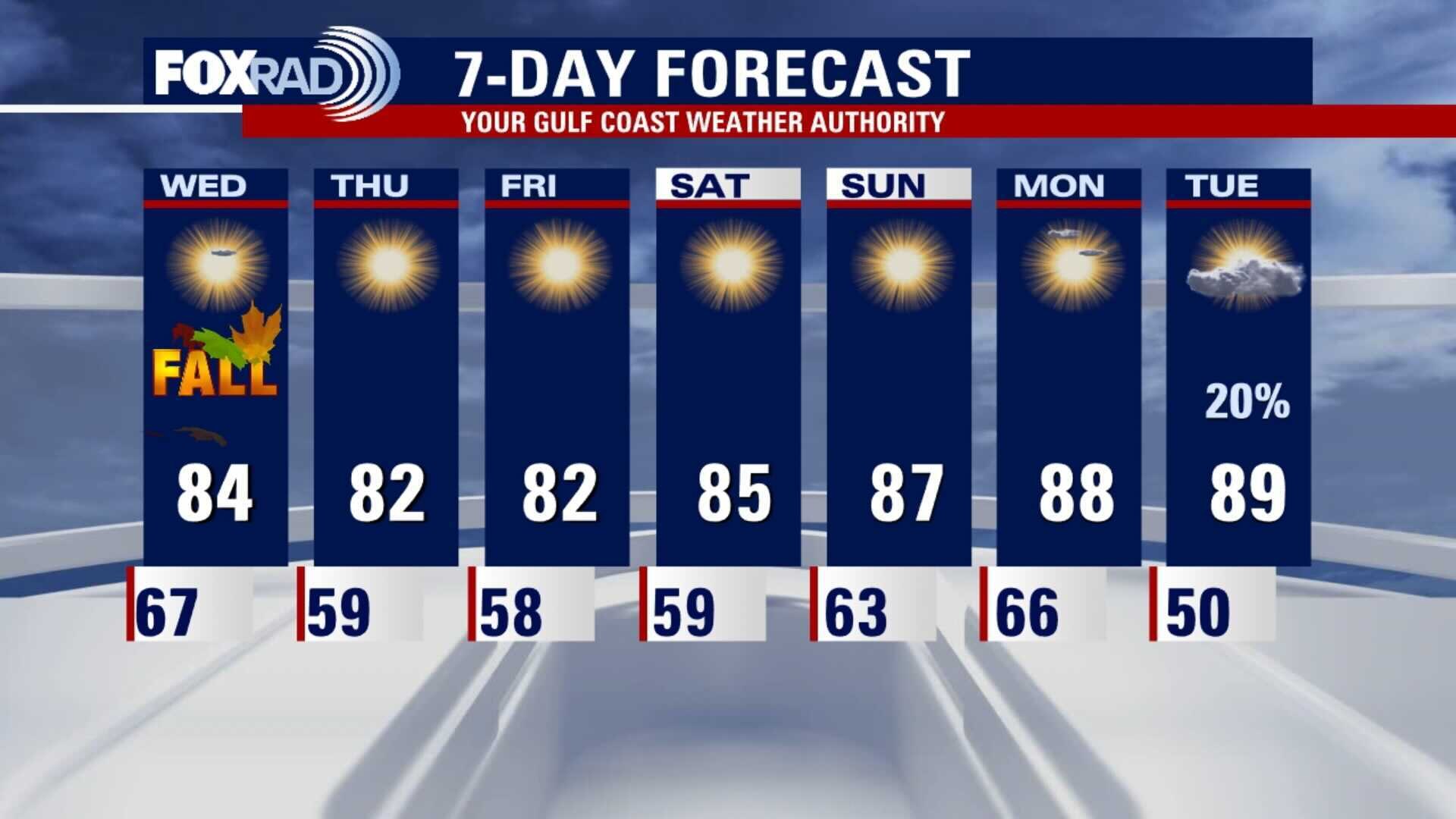
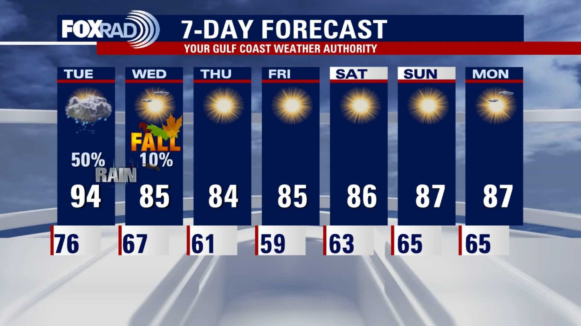
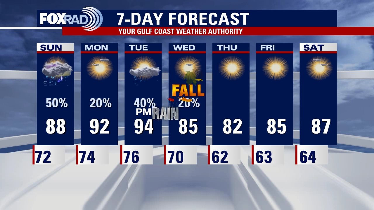
Today may be the hottest day we have until well into 2022. Our highs will likely reach the mid 90s before a late-day cold front brings cooler and drier air to usher in the fall season which begins Wednesday. Look for highs in the 80s and lows in the 50s and 60s through the weekend with very pleasant humidity.
Today may be the hottest day we have until well into 2022. Our highs will likely reach the mid 90s before a late-day cold front brings cooler and drier air to usher in the fall season which begins Wednesday. Look for highs in the 80s and lows in the 50s and 60s through the weekend with very pleasant humidity.

Monday night weather leading into Tuesday morning weather forecast
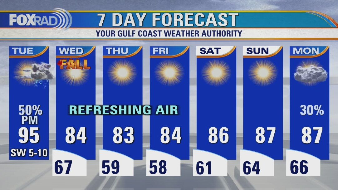
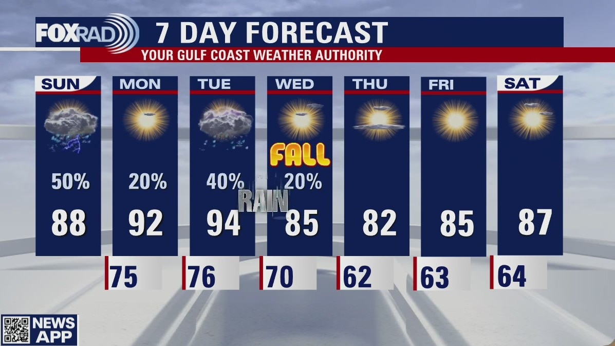
A real front will arrive later on Tuesday and there will be some showers and storms as it pushes through SE Texas. Fall officially begins Wednesday and it's going to feel like it. Lows will dip into the 50s early on Friday and I can't wait for the cooler and drier air.
A real front will arrive later on Tuesday and there will be some showers and storms as it pushes through SE Texas. Fall officially begins Wednesday and it's going to feel like it. Lows will dip into the 50s early on Friday and I can't wait for the cooler and drier air.
Monday evening weather forecast with Chief Meteorologist Dr. Jim Siebert
A real front will arrive later on Tuesday and there will be some showers and storms as it pushes through SE Texas. Fall officially begins Wednesday and it's going to feel like it. Lows will dip into the 50s early on Friday and I can't wait for the cooler and drier air.
A real front will arrive later on Tuesday and there will be some showers and storms as it pushes through SE Texas. Fall officially begins Wednesday and it's going to feel like it. Lows will dip into the 50s early on Friday and I can't wait for the cooler and drier air.
Monday weather forecast
Hot and humid with isolated afternoon storms. Highs in the low to mid 90s.
Hot and humid with isolated afternoon storms. Highs in the low to mid 90s.
Sunday weather forecast
Did you see rain this weekend? Most of us won't see any again until Tuesday night when the much talked about cold front moves into Southeast Texas. Things are still on track for fabulous Fall weather around Houston at the end of the week. Time to start making some outdoor plans!
Did you see rain this weekend? Most of us won't see any again until Tuesday night when the much talked about cold front moves into Southeast Texas. Things are still on track for fabulous Fall weather around Houston at the end of the week. Time to start making some outdoor plans!
Sunday's weather and a look ahead
FOX 26 Meteorologist Lena Maria Arango has today's weather and a look at the week ahead.
FOX 26 Meteorologist Lena Maria Arango has today's weather and a look at the week ahead.
Saturday weather forecast with Meteorologist John Dawson
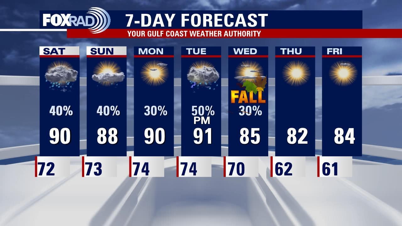
Fall is right around the corner and it looks like Houston will see cooler temps following the Autumn Equinox. Look for a 70% chance for rain Tuesday night. Speaking of rain, expect more scattered showers to wrap up the weekend on Sunday afternoon.
Fall is right around the corner and it looks like Houston will see cooler temps following the Autumn Equinox. Look for a 70% chance for rain Tuesday night. Speaking of rain, expect more scattered showers to wrap up the weekend on Sunday afternoon.

Saturday weather
FOX 26 meteorologist Lena Maria Arango takes a look at the weeken weather and the 7 day forecast.
FOX 26 meteorologist Lena Maria Arango takes a look at the weeken weather and the 7 day forecast.
Friday night leading into Saturday morning weather forecast
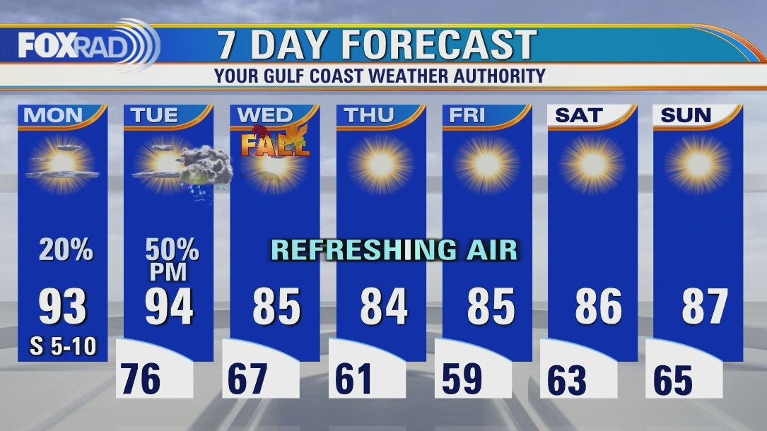
A somewhat summer-like pattern returns to Southeast Texas for this weekend. Don't look for the hot upper 90s, but those familiar afternoon scattered storms will find their way around Houston. After a quiet Monday, we start looking to the north to see how much of a cold front will make it to the Gulf coast. There are still some questions on exactly when and how cold, but it does look like a taste of September for the first official day of Fall.
A somewhat summer-like pattern returns to Southeast Texas for this weekend. Don't look for the hot upper 90s, but those familiar afternoon scattered storms will find their way around Houston. After a quiet Monday, we start looking to the north to see how much of a cold front will make it to the Gulf coast. There are still some questions on exactly when and how cold, but it does look like a taste of September for the first official day of Fall.

Friday evening weather forecast with Meteorologist John Dawson
A somewhat summer-like pattern returns to Southeast Texas for this weekend. Don't look for the hot upper 90s, but those familiar afternoon scattered storms will find their way around Houston. After a quiet Monday, we start looking to the north to see how much of a cold front will make it to the Gulf coast. There are still some questions on exactly when and how cold, but it does look like a taste of September for the first official day of Fall.
A somewhat summer-like pattern returns to Southeast Texas for this weekend. Don't look for the hot upper 90s, but those familiar afternoon scattered storms will find their way around Houston. After a quiet Monday, we start looking to the north to see how much of a cold front will make it to the Gulf coast. There are still some questions on exactly when and how cold, but it does look like a taste of September for the first official day of Fall.

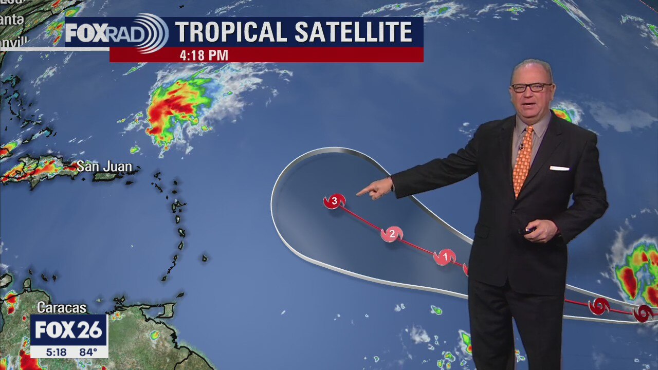
Tropical Weather Forecast - Sept. 17, 2021
The Atlantic Basin remains very active with a new tropical storm forming on Friday. Things should remain quiet for Texas and the Gulf of Mexico for the next several days. FOX 26 Meteorologist John Dawson also takes a look back at the life of Nicholas in this tropical briefing.
The Atlantic Basin remains very active with a new tropical storm forming on Friday. Things should remain quiet for Texas and the Gulf of Mexico for the next several days. FOX 26 Meteorologist John Dawson also takes a look back at the life of Nicholas in this tropical briefing.
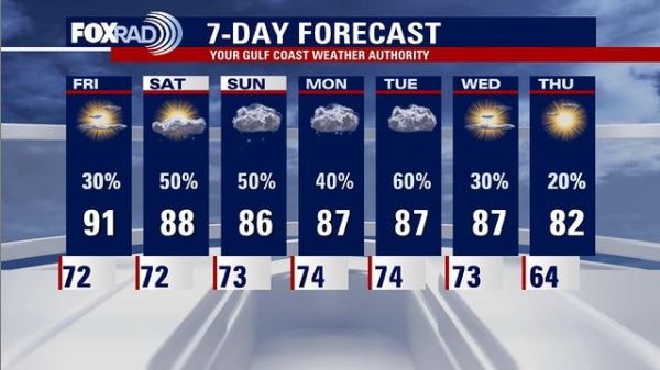
Friday weather forecast
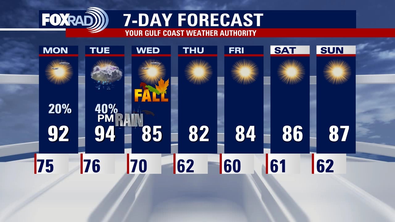
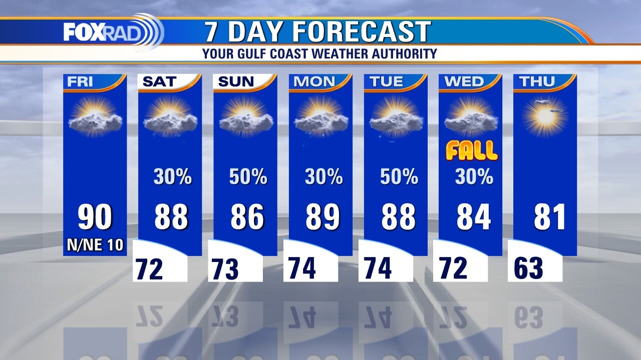
As the remnants of Nicholas exit to our east, we settle back into a fairly normal weather pattern in southeast Texas. Plan on highs right around 90 degrees, with daily shower/thunderstorm chances. A cold front looks to arrive, ironically on the first day of Fall next Wednesday and while exact timing and impacts of the frontal passage are uncertain... dry, cool weather looks to move in behind it.
As the remnants of Nicholas exit to our east, we settle back into a fairly normal weather pattern in southeast Texas. Plan on highs right around 90 degrees, with daily shower/thunderstorm chances. A cold front looks to arrive, ironically on the first day of Fall next Wednesday and while exact timing and impacts of the frontal passage are uncertain... dry, cool weather looks to move in behind it.
Thursday night leading into Friday morning weather forecast
We are almost back to normal with our weather for SE Texas. Highs will be close to 90 degrees and there's a daily chance for a few light showers. The next front will arrive around Wednesday, but the timing and impacts are still in question.
We are almost back to normal with our weather for SE Texas. Highs will be close to 90 degrees and there's a daily chance for a few light showers. The next front will arrive around Wednesday, but the timing and impacts are still in question.

Thursday evening weather forecast with Chief Meteorologist Dr. Jim Siebert
We are almost back to normal with our weather for SE Texas. Highs will be close to 90 degrees and there's a daily chance for a few light showers. The next front will arrive around Wednesday, but the timing and impacts are still in question.
We are almost back to normal with our weather for SE Texas. Highs will be close to 90 degrees and there's a daily chance for a few light showers. The next front will arrive around Wednesday, but the timing and impacts are still in question.
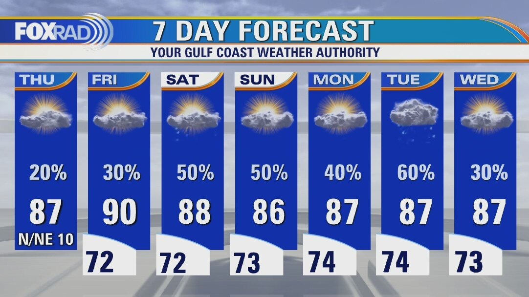
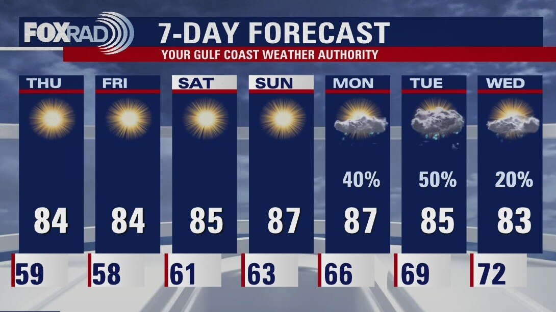
Thursday weather forecast
Partly cloudy and mild with isolated showers and highs in the mid to upper 80s.
Partly cloudy and mild with isolated showers and highs in the mid to upper 80s.