


Houston weather: Get ready for heat, heat, and more heat!
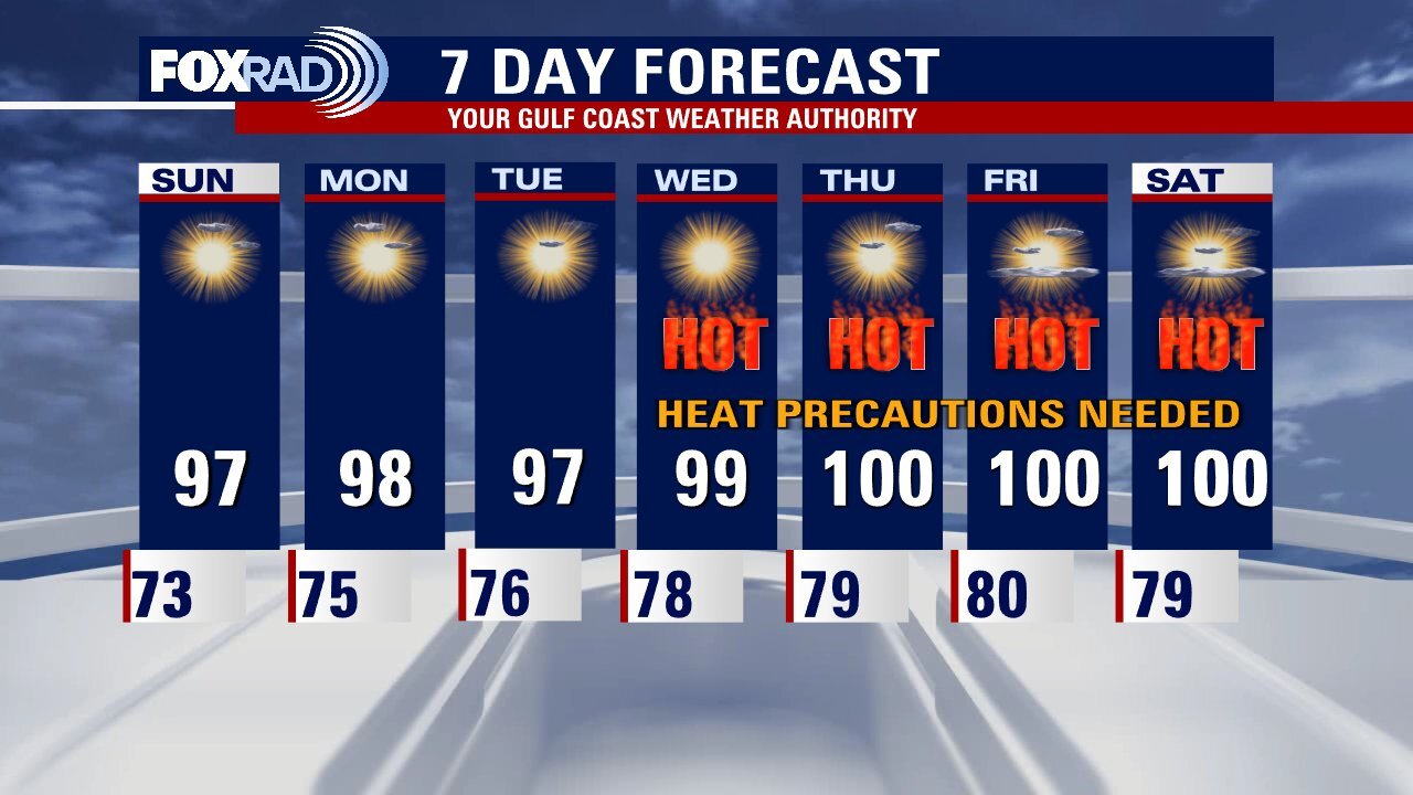
The first major heatwave of the season is here! Summer is still eight days away but we will be feeling that summer heat through the rest of the week! Heat Advisory remains in place for Austin, Colorado, Wharton & Jackson counties until 8 PM. Heat Advisory is also in effect for the Houston area from 1 - 7 PM Wednesday with heat index values up to 110 likely. Take frequent breaks in the shade and drink lots of water if you must work outside. It's also best to get any strenuous activity out of the way in the early morning or evening and avoid being outside during the hottest part of the day, Temperatures will climb to near 100 Wednesday and make it up to triple digits Thursday through the weekend. The heat lingers into early next week also. Rain chances appear to be slim to none with a big ridge of high pressure building in.
The first major heatwave of the season is here! Summer is still eight days away but we will be feeling that summer heat through the rest of the week! Heat Advisory remains in place for Austin, Colorado, Wharton & Jackson counties until 8 PM. Heat Advisory is also in effect for the Houston area from 1 - 7 PM Wednesday with heat index values up to 110 likely. Take frequent breaks in the shade and drink lots of water if you must work outside. It's also best to get any strenuous activity out of the way in the early morning or evening and avoid being outside during the hottest part of the day, Temperatures will climb to near 100 Wednesday and make it up to triple digits Thursday through the weekend. The heat lingers into early next week also. Rain chances appear to be slim to none with a big ridge of high pressure building in.


Houston Weather: Texas under heat advisory with scorching temperatures expected
The first major heatwave of the season is here! Summer is still 8 days away but we will be feeling that summer heat through the rest of the week! Heat Advisory remains in place for Austin, Colorado, Wharton & Jackson counties until 8 PM. Heat Advisory is also in effect for the Houston area from 1 - 7 PM Wednesday with heat index values up to 110 likely. Take frequent breaks in the shade and drink lots of water if you must work outside. It's also best to get any strenuous activity out of the way in the early morning or evening and avoid being outside during the hottest part of the day, Temperatures will climb to near 100 Wednesday and make it up to triple digits Thursday through the weekend. The heat lingers into early next week also. Rain chances appear to be slim to none with a big ridge of high pressure building in.
The first major heatwave of the season is here! Summer is still 8 days away but we will be feeling that summer heat through the rest of the week! Heat Advisory remains in place for Austin, Colorado, Wharton & Jackson counties until 8 PM. Heat Advisory is also in effect for the Houston area from 1 - 7 PM Wednesday with heat index values up to 110 likely. Take frequent breaks in the shade and drink lots of water if you must work outside. It's also best to get any strenuous activity out of the way in the early morning or evening and avoid being outside during the hottest part of the day, Temperatures will climb to near 100 Wednesday and make it up to triple digits Thursday through the weekend. The heat lingers into early next week also. Rain chances appear to be slim to none with a big ridge of high pressure building in.


Houston weather: Hot Tuesday; some area counties under heat advisory
Some western counties in the FOX 26 area are under a Heat Advisory from the National Weather Service. Expect more advisories for the rest of us as we move through this unusually hot week in Southeast Texas. Houston will probably break some afternoon high temperatures as we move into a stretch of triple digits all the way through the weekend. Be safe outdoors in this heat.
Some western counties in the FOX 26 area are under a Heat Advisory from the National Weather Service. Expect more advisories for the rest of us as we move through this unusually hot week in Southeast Texas. Houston will probably break some afternoon high temperatures as we move into a stretch of triple digits all the way through the weekend. Be safe outdoors in this heat.


Houston Weather: More scorching heat expected with temperatures climbing into triple digits
The hottest week so far this year is upon us with triple-digit temperatures expected by the middle and end of the week! Humidity will increase also which will mean heat advisories likely to be issued later this week. Heat index values will approach 110 or higher by Thursday and Friday! So that means taking frequent breaks while working outside, drinking plenty of water, and wearing loose-fitting, light-colored clothing. There's a small chance for an isolated storm to clip our northern counties this evening but most will stay dry. In fact, this week's weather pattern features tons of heat with little to no rain. Stay safe in the heat and download our FOX 26 WX App for the latest weather updates!
The hottest week so far this year is upon us with triple-digit temperatures expected by the middle and end of the week! Humidity will increase also which will mean heat advisories likely to be issued later this week. Heat index values will approach 110 or higher by Thursday and Friday! So that means taking frequent breaks while working outside, drinking plenty of water, and wearing loose-fitting, light-colored clothing. There's a small chance for an isolated storm to clip our northern counties this evening but most will stay dry. In fact, this week's weather pattern features tons of heat with little to no rain. Stay safe in the heat and download our FOX 26 WX App for the latest weather updates!

Houston Weather: Temperatures to climb into the triple digits during possibly the hottest week of 2023
The hottest week so far this year is upon us with triple-digit temperatures expected by the middle and end of the week! Humidity will increase also which will mean heat advisories likely to be issued later this week. Heat index values will approach 110 or higher by Thursday and Friday! So that means taking frequent breaks while working outside, drinking plenty of water, and wearing loose-fitting, light-colored clothing. There's a small chance for an isolated storm to clip our northern counties this evening but most will stay dry. In fact, this week's weather pattern features tons of heat with little to no rain. Stay safe in the heat and download our FOX 26 WX App for the latest weather updates!
The hottest week so far this year is upon us with triple-digit temperatures expected by the middle and end of the week! Humidity will increase also which will mean heat advisories likely to be issued later this week. Heat index values will approach 110 or higher by Thursday and Friday! So that means taking frequent breaks while working outside, drinking plenty of water, and wearing loose-fitting, light-colored clothing. There's a small chance for an isolated storm to clip our northern counties this evening but most will stay dry. In fact, this week's weather pattern features tons of heat with little to no rain. Stay safe in the heat and download our FOX 26 WX App for the latest weather updates!

Heat wave expected to come towards Houston
Temperatures are expected to rise throughout the week with a possibility of triple digits starting Thursday. Pollen levels are expected to rise slightly with the heat.
Temperatures are expected to rise throughout the week with a possibility of triple digits starting Thursday. Pollen levels are expected to rise slightly with the heat.

As Houston expects warm weather conditions, John Dawson shows us how to beat the heat.
Houston expects warm days with high temperatures. John Dawson shares best practice reminders on heat safety.
Houston expects warm days with high temperatures. John Dawson shares best practice reminders on heat safety.

Houston weather: Very hot and sunny afternoon Monday
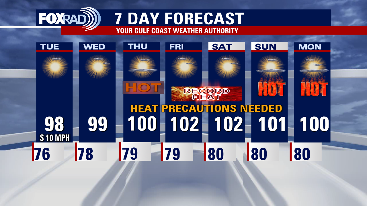
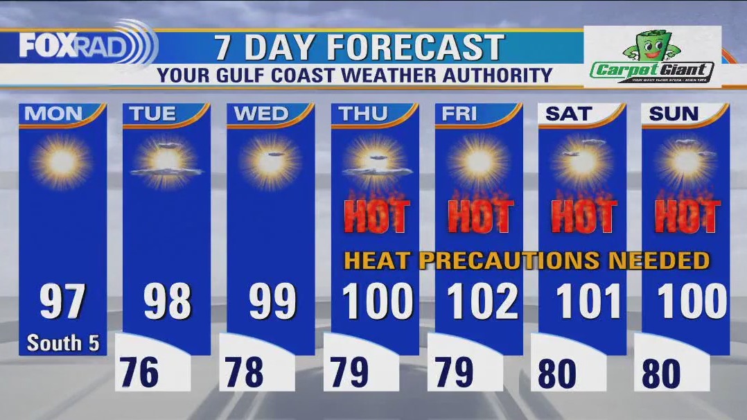
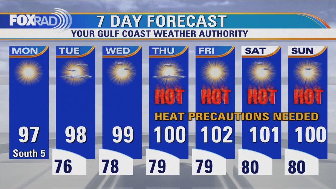
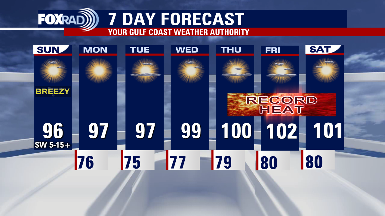
Get ready for the hottest week of the year and our first triple digits of the season! A heat dome is expected to build over us and this pattern will mean very hot weather and little to no rain. Hottest weather should arrive by the middle and end of the week when Houston will be in the triple digits. Heat advisories are likely with heat index values expected to reach 108+ by Wednesday. This is dangerous heat coming early in the season so take all precautions to stay safe! Drink plenty of water, take breaks in the shade while working outside and avoid being outside during the hottest part of the day if possible.
Get ready for the hottest week of the year and our first triple digits of the season! A heat dome is expected to build over us and this pattern will mean very hot weather and little to no rain. Hottest weather should arrive by the middle and end of the week when Houston will be in the triple digits. Heat advisories are likely with heat index values expected to reach 108+ by Wednesday. This is dangerous heat coming early in the season so take all precautions to stay safe! Drink plenty of water, take breaks in the shade while working outside and avoid being outside during the hottest part of the day if possible.

Houston-weather: Prepare for the heatwave this week!
Get ready for what will likely be the hottest week of the year so far and our first triple digits of the season! A heat dome is expected to build over us and this pattern will mean very hot weather and little to no rain for the next several days. Hottest weather should arrive by the middle and end of the week when we will be in the triple digits and flirting with record high temperatures! Heat advisories are likely later this week with heat index values expected to reach 108+ by Wednesday! This is dangerous heat coming early in the season so take all precautions to stay safe! Drink plenty of water, take breaks in the shade while working outside and avoid being outside during the hottest part of the day if possible! Also make sure to download our FOX 26 Weather App to keep track of the heat wave coming and any other weather changes.
Get ready for what will likely be the hottest week of the year so far and our first triple digits of the season! A heat dome is expected to build over us and this pattern will mean very hot weather and little to no rain for the next several days. Hottest weather should arrive by the middle and end of the week when we will be in the triple digits and flirting with record high temperatures! Heat advisories are likely later this week with heat index values expected to reach 108+ by Wednesday! This is dangerous heat coming early in the season so take all precautions to stay safe! Drink plenty of water, take breaks in the shade while working outside and avoid being outside during the hottest part of the day if possible! Also make sure to download our FOX 26 Weather App to keep track of the heat wave coming and any other weather changes.

Houston weather: The heat is here! Be sure to stay hydrated!
Get ready for what will likely be the hottest week of the year so far and our first triple digits of the season! A heat dome is expected to build over us and this pattern will mean very hot weather and little to no rain for the next several days. Hottest weather should arrive by the middle and end of the week when we will be in the triple digits and flirting with record high temperatures! Heat advisories are likely later this week with heat index values expected to reach 108+ by Wednesday! This is dangerous heat coming early in the season so take all precautions to stay safe! Drink plenty of water, take breaks in the shade while working outside and avoid being outside during the hottest part of the day if possible! Also make sure to download our FOX 26 Weather App to keep track of the heat wave coming and any other weather changes.
Get ready for what will likely be the hottest week of the year so far and our first triple digits of the season! A heat dome is expected to build over us and this pattern will mean very hot weather and little to no rain for the next several days. Hottest weather should arrive by the middle and end of the week when we will be in the triple digits and flirting with record high temperatures! Heat advisories are likely later this week with heat index values expected to reach 108+ by Wednesday! This is dangerous heat coming early in the season so take all precautions to stay safe! Drink plenty of water, take breaks in the shade while working outside and avoid being outside during the hottest part of the day if possible! Also make sure to download our FOX 26 Weather App to keep track of the heat wave coming and any other weather changes.

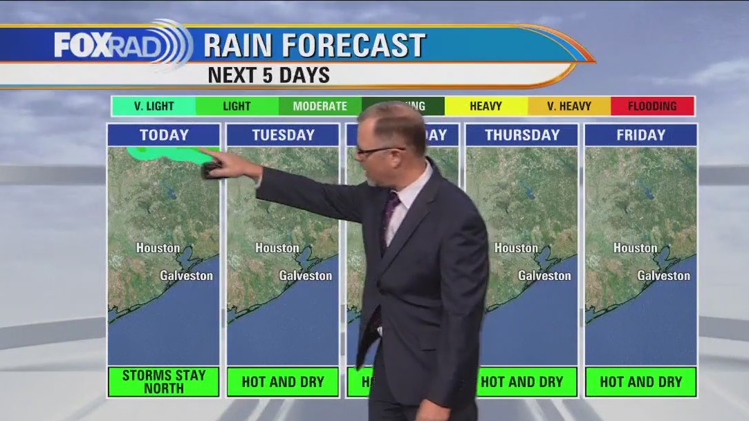
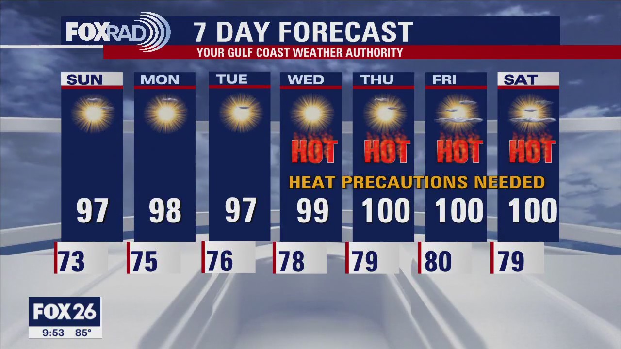
Houston Weather: Scattered showers still possible, but intense heat is the focus all week-long
Aside from a very isolated shower or storm far north today and tomorrow, hot and dry conditions are taking over. Heat precautions will need to be taken all week long, but especially toward the end of the week when we soar toward record values both for daytime highs and overnight lows. Our first 100+ degree day normally doesn't occur until mid-July, so this is about a month ahead of schedule and a week before summer officially begins. The Tropical Atlantic remains quiet at this time.
Aside from a very isolated shower or storm far north today and tomorrow, hot and dry conditions are taking over. Heat precautions will need to be taken all week long, but especially toward the end of the week when we soar toward record values both for daytime highs and overnight lows. Our first 100+ degree day normally doesn't occur until mid-July, so this is about a month ahead of schedule and a week before summer officially begins. The Tropical Atlantic remains quiet at this time.

Houston Weather: The intense heat now a focus after the storms
Storms moved across the Southeast Texas area, now it is all about the heat. A dome of high pressure will build in place and lock Houston into a very hot pattern. Look for triple digits by the end of the week and possible heat advisories.
Storms moved across the Southeast Texas area, now it is all about the heat. A dome of high pressure will build in place and lock Houston into a very hot pattern. Look for triple digits by the end of the week and possible heat advisories.

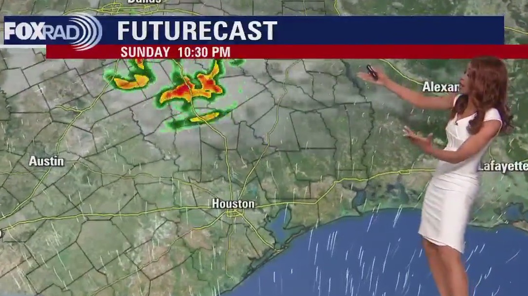
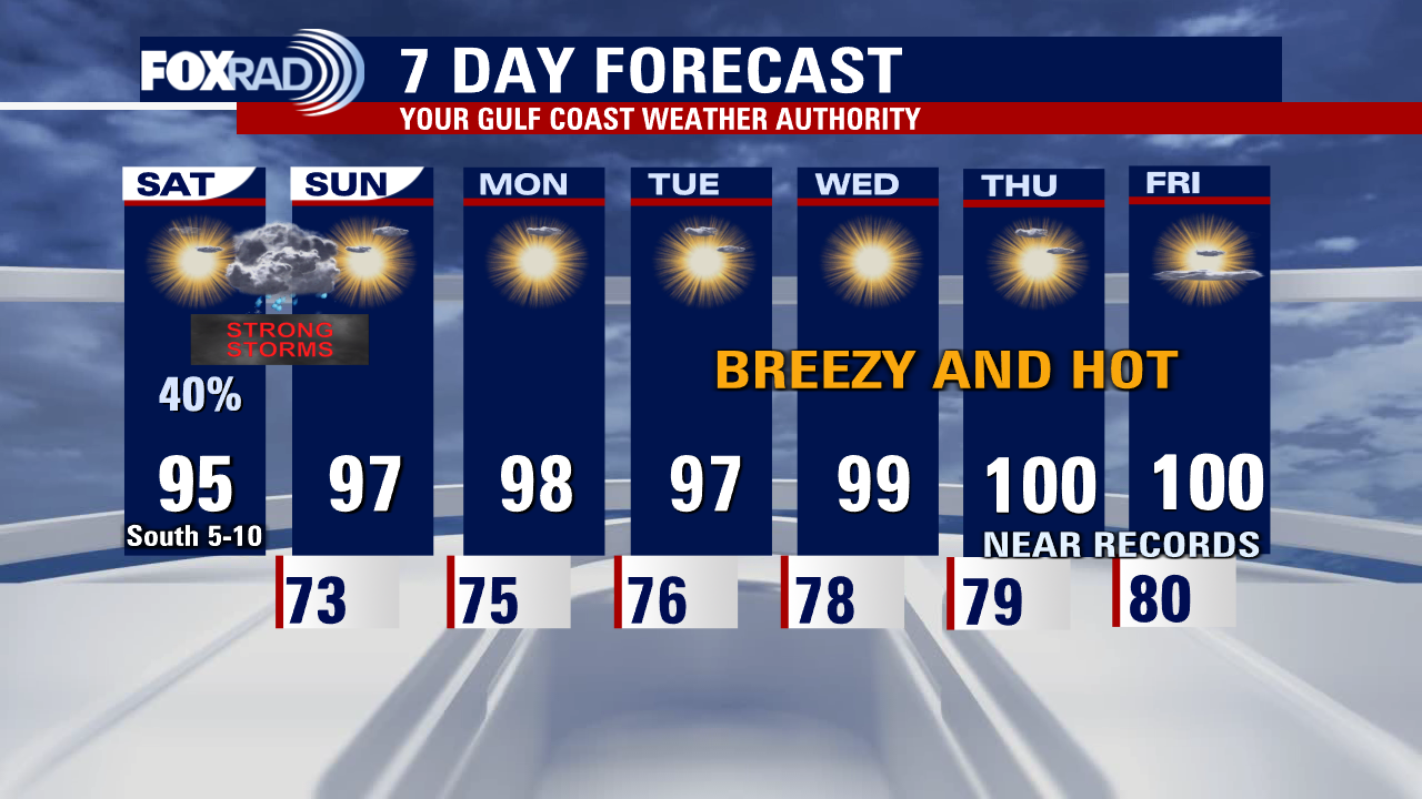
Few storms expected Saturday night, then expect temperatures in triple digits
A few storms across Southeast Texas on Saturday evening and then it is all about the heat. A dome of high pressure will build in place and lock Houston into a very hot pattern. Look for triple digits by the end of the week and possible heat advisories.
A few storms across Southeast Texas on Saturday evening and then it is all about the heat. A dome of high pressure will build in place and lock Houston into a very hot pattern. Look for triple digits by the end of the week and possible heat advisories.

Houston Weather: Hot now, but look out for severe storms late Saturday night
While most of today will be hot and dry, be on the lookout for strong to severe storms late tonight. Areas north have the highest likelihood of seeing large hail, and damaging winds mainly between 7 p.m. - midnight. Next week is all about the heat, and while we'll approach records toward the end at least there will be plenty of wind and solar energy to help the grid! Feels like values will be 5-10 degrees above actual temperatures, so practicing heat safety will be imperative.
While most of today will be hot and dry, be on the lookout for strong to severe storms late tonight. Areas north have the highest likelihood of seeing large hail, and damaging winds mainly between 7 p.m. - midnight. Next week is all about the heat, and while we'll approach records toward the end at least there will be plenty of wind and solar energy to help the grid! Feels like values will be 5-10 degrees above actual temperatures, so practicing heat safety will be imperative.

Houston-weather: The heat is on! Very hot weather in the weekend forecast, storms possible Saturday night
Storms across North Texas may creep into Southeast Texas late on Saturday. Most of the day will be dry and hot but keep an eye to the north of Houston as the sun starts to set. The weekend ends warm and dry as we shift to a pattern that will bring very hot temperatures. Be safe with your outdoor activities at the end of the week.
Storms across North Texas may creep into Southeast Texas late on Saturday. Most of the day will be dry and hot but keep an eye to the north of Houston as the sun starts to set. The weekend ends warm and dry as we shift to a pattern that will bring very hot temperatures. Be safe with your outdoor activities at the end of the week.

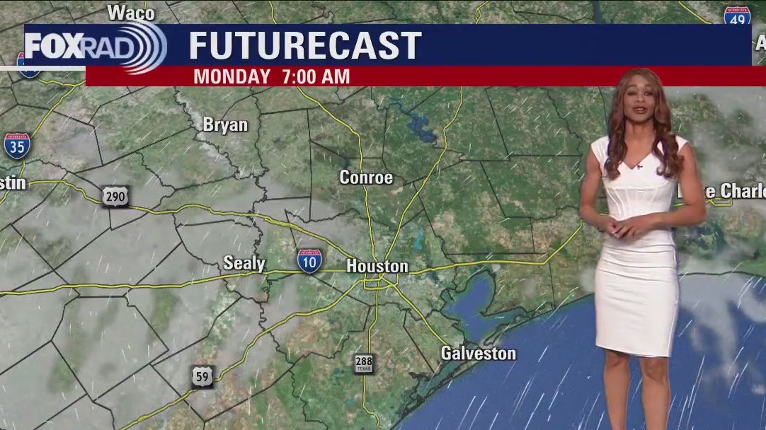
Houston Weather: Late day thunderstorms for Saturday with temperatures expected to rise Monday
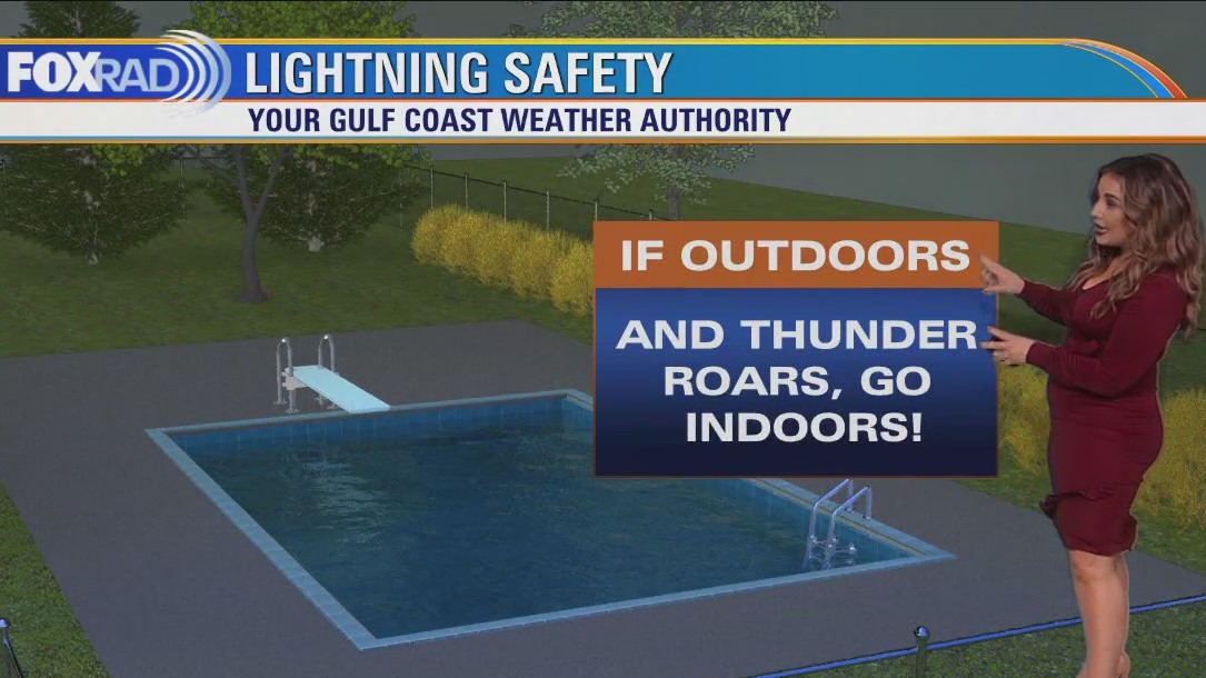
Late day thunderstorms are expected for Saturday. By Monday temperatures are expected to rise likely near triple digits. Lena Maria also talks to us about lightning safety.
Late day thunderstorms are expected for Saturday. By Monday temperatures are expected to rise likely near triple digits. Lena Maria also talks to us about lightning safety.


Houston weather: Severe thunderstorms expected for Saturday
Lena Maria shares Houston's daily forecast. Severe storms expected for Saturday.
Lena Maria shares Houston's daily forecast. Severe storms expected for Saturday.
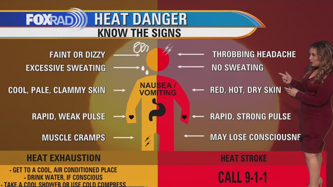

Preparing for summer heat; what you should know
Triple digital temperatures are returning to the Houston-area in the coming days.
Triple digital temperatures are returning to the Houston-area in the coming days.

Severe thunderstorms rolled through Houston Thursday; less severe storms expected for Friday
Another hot and hazy day, with quiet conditions and sunshine to start and a few isolated downpours or rumbles of thunder later this afternoon. While much less coverage and intensity of storms is expected today, Saturday evening could get rowdy again if storms approaching from the north hold together. They may dissipate upon approach, and past that rain chances dwindle as a heat dome builds. Triple digit feels like values will begin this weekend, so take breaks often in the shade and stay hydrated if spending extended periods of time outdoors especially during peak heating of the day. Don't forget about your furry friends as well, and LOOK before you LOCK.
Another hot and hazy day, with quiet conditions and sunshine to start and a few isolated downpours or rumbles of thunder later this afternoon. While much less coverage and intensity of storms is expected today, Saturday evening could get rowdy again if storms approaching from the north hold together. They may dissipate upon approach, and past that rain chances dwindle as a heat dome builds. Triple digit feels like values will begin this weekend, so take breaks often in the shade and stay hydrated if spending extended periods of time outdoors especially during peak heating of the day. Don't forget about your furry friends as well, and LOOK before you LOCK.

Houston weather: Thunderstorm Warning for parts of Harris County, few severe storms
Strong to severe storms are possible across all of SE TX through early tonight as a disturbance moves through. Large hail, heavy rain, frequent lightning & damaging winds are all possible through about 10 PM. Storms will be dropping SE towards the coast and could get feisty. Make sure to stay alert & download our FOX 26 WX App to keep track of the threatening weather. A pattern shift is still scheduled for the weekend and much of next week with hotter and drier weather returning. We will be flirting with triple digits next week with some parts of SE TX close to heat advisory criteria by the middle and end of next week!
Strong to severe storms are possible across all of SE TX through early tonight as a disturbance moves through. Large hail, heavy rain, frequent lightning & damaging winds are all possible through about 10 PM. Storms will be dropping SE towards the coast and could get feisty. Make sure to stay alert & download our FOX 26 WX App to keep track of the threatening weather. A pattern shift is still scheduled for the weekend and much of next week with hotter and drier weather returning. We will be flirting with triple digits next week with some parts of SE TX close to heat advisory criteria by the middle and end of next week!