


Thursday weather forecast
This morning?s low temperature of 31 was the second freeze of the season for Houston and should be the last for about a week. Two more cold fronts are on the way - one on Saturday and the next on Wednesday. Watch for showers late Friday and into Saturday. The front on Wednesday could bring very cold, windy conditions for Christmas Eve and a cold Christmas morning.
This morning?s low temperature of 31 was the second freeze of the season for Houston and should be the last for about a week. Two more cold fronts are on the way - one on Saturday and the next on Wednesday. Watch for showers late Friday and into Saturday. The front on Wednesday could bring very cold, windy conditions for Christmas Eve and a cold Christmas morning.
Thursday morning weather forecast
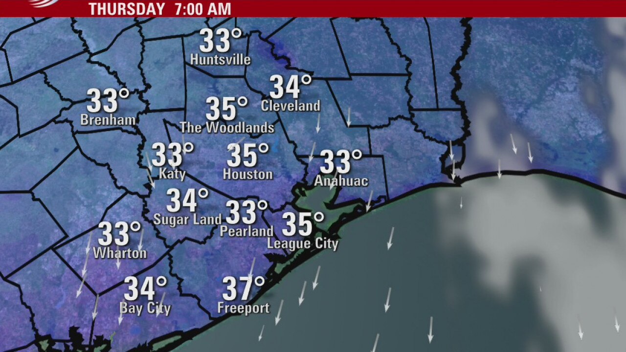
A light freeze is possible across SE Texas and Houston tonight so take precautions for pets, pipes and plants. Some areas will get to only 33 degrees, but many will dip below 32. Friday looks cool and sunny with highs near 60 degrees and a bit warmer this weekend.
A light freeze is possible across SE Texas and Houston tonight so take precautions for pets, pipes and plants. Some areas will get to only 33 degrees, but many will dip below 32. Friday looks cool and sunny with highs near 60 degrees and a bit warmer this weekend.
Wednesday night weather forecast
A light freeze is possible across SE Texas and Houston tonight so take precautions for pets, pipes and plants. Some areas will get to only 33 degrees, but many will dip below 32. Friday looks cool and sunny with highs near 60 degrees and a bit warmer this weekend.
A light freeze is possible across SE Texas and Houston tonight so take precautions for pets, pipes and plants. Some areas will get to only 33 degrees, but many will dip below 32. Friday looks cool and sunny with highs near 60 degrees and a bit warmer this weekend.
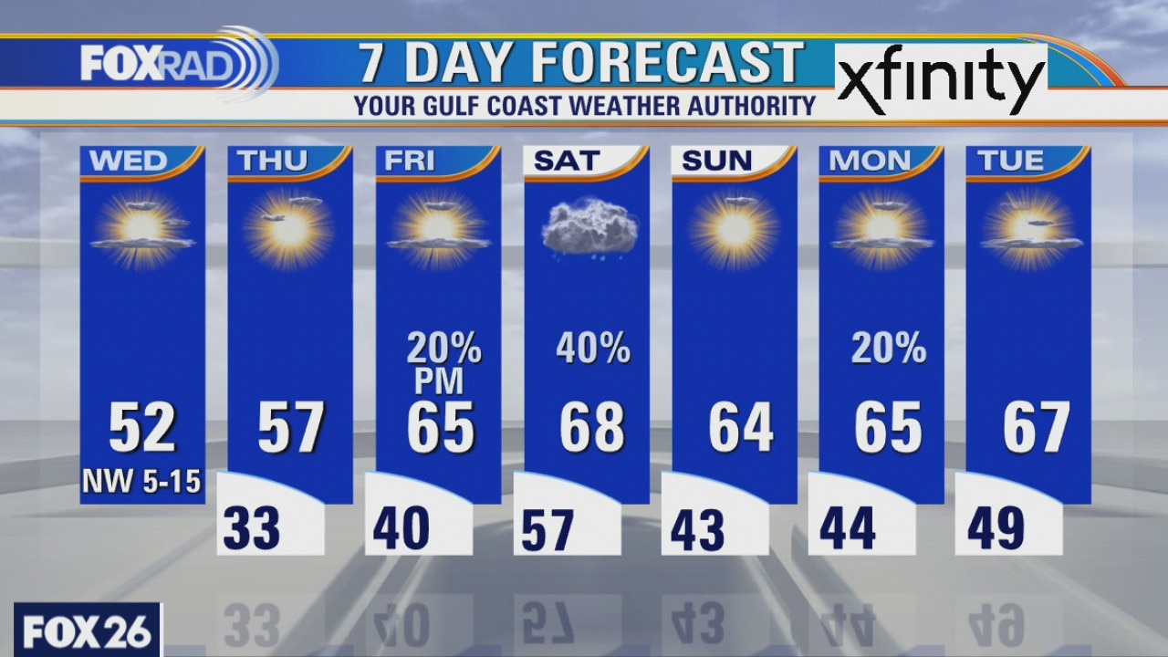
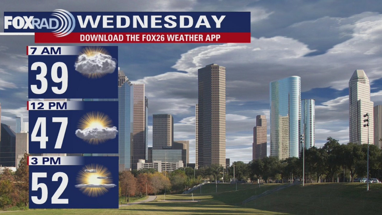
Wednesday weather forecast
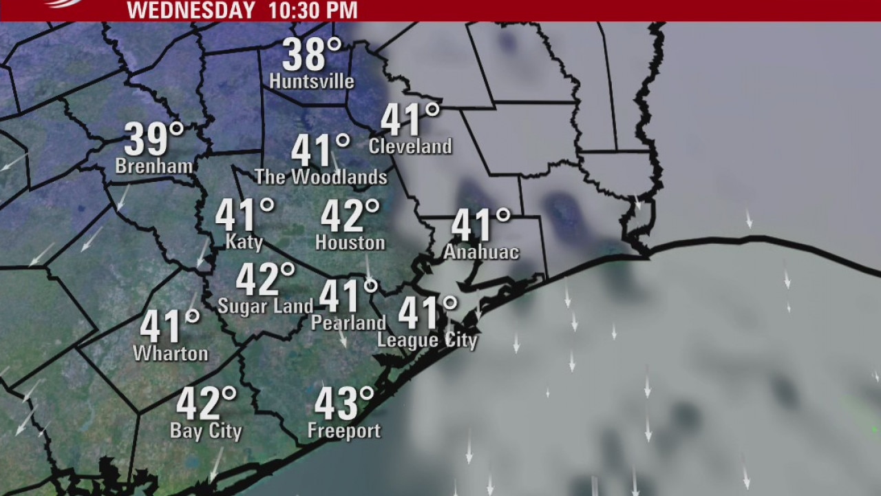
It?s going to be chilly again today, but with some afternoon sun in most spots. Prepare for a light freeze/frost tonight, so bring pets inside and cover vulnerable plants. Look for showers Friday night and Saturday morning along with seasonably cool temps.
It?s going to be chilly again today, but with some afternoon sun in most spots. Prepare for a light freeze/frost tonight, so bring pets inside and cover vulnerable plants. Look for showers Friday night and Saturday morning along with seasonably cool temps.
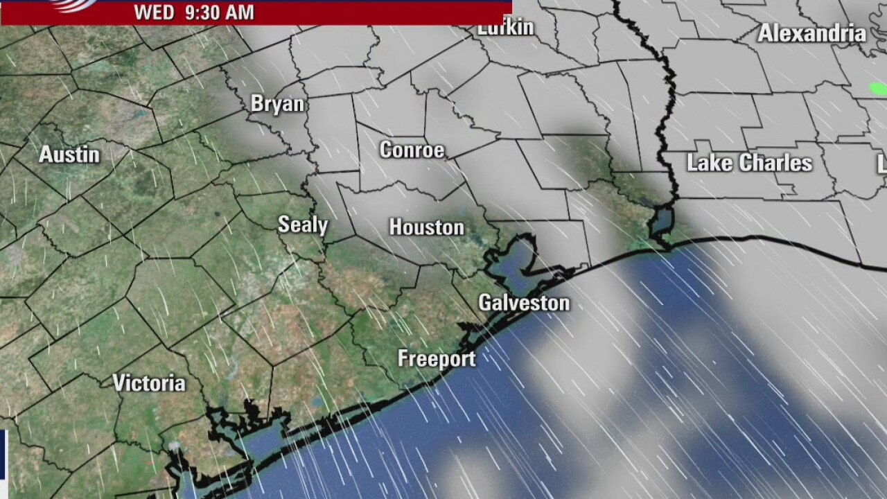
Wednesday morning weather forecast
It will be chilly over the next couple of days and a light freeze will be possible for some areas early Thursday morning. We warm back into the 60s by the end of the week and will see some showers again by early Saturday morning.
It will be chilly over the next couple of days and a light freeze will be possible for some areas early Thursday morning. We warm back into the 60s by the end of the week and will see some showers again by early Saturday morning.
Tuesday Evening Weather Forecast
It will be chilly over the next couple of days and a light freeze will be possible for some areas early Thursday morning. We warm back into the 60s by the end of the week and will see some showers again by early Saturday morning.
It will be chilly over the next couple of days and a light freeze will be possible for some areas early Thursday morning. We warm back into the 60s by the end of the week and will see some showers again by early Saturday morning.
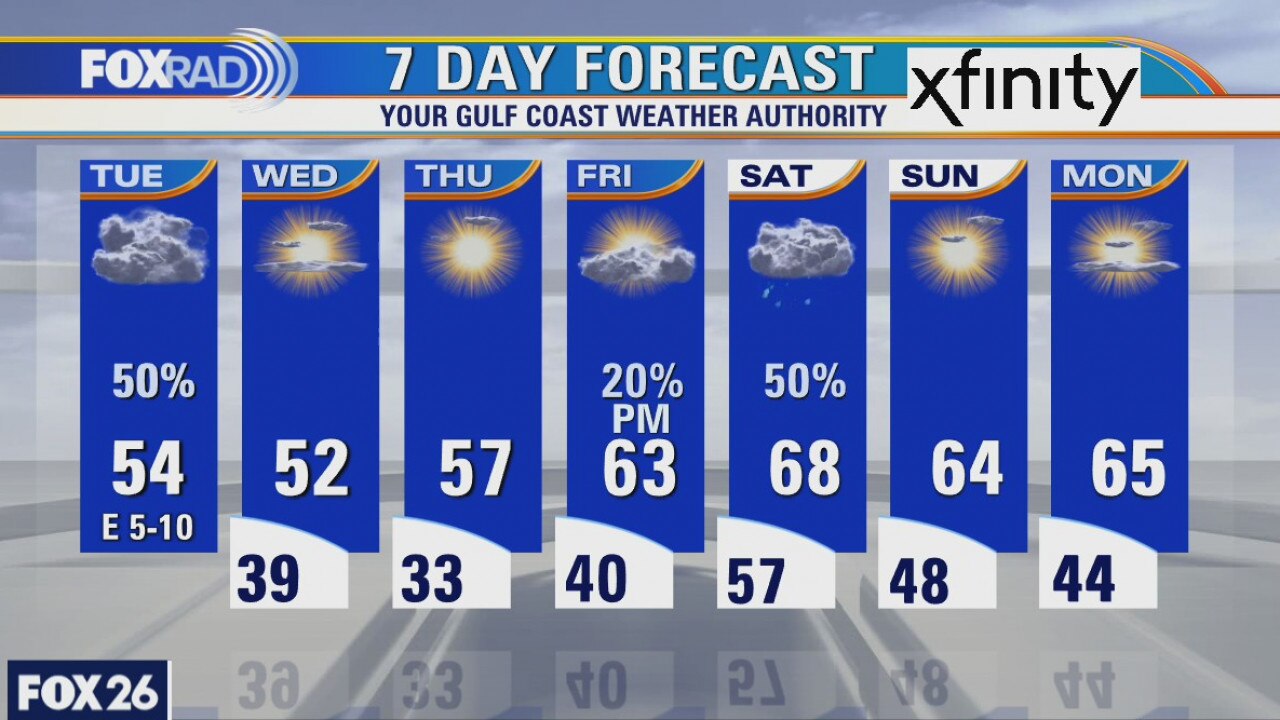
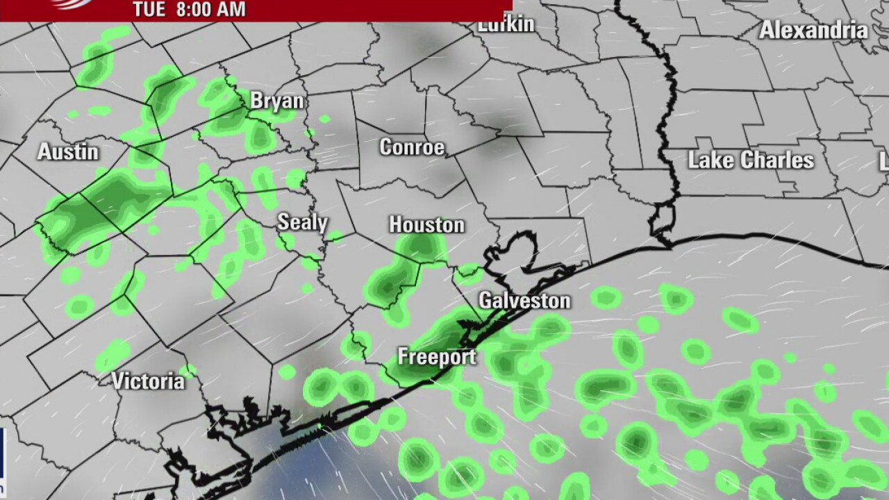
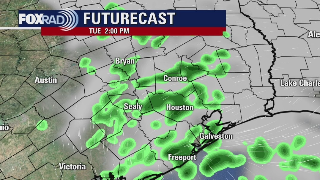
Tuesday weather forecast
A cool start to our Tuesday and it will only get colder before a brief warmup is expected later in the week. Expect a few showers to develop later this morning as an area of low pressure treks along the Texas coastline. The best shot at rain will come mainly east of I-45. As the showers pass, a cold front will be sweeping through the area to reinforce the chilly air already in place. Highs will struggle to get out of the 40s on Wednesday and Thursday morning could be a frosty morning.
A cool start to our Tuesday and it will only get colder before a brief warmup is expected later in the week. Expect a few showers to develop later this morning as an area of low pressure treks along the Texas coastline. The best shot at rain will come mainly east of I-45. As the showers pass, a cold front will be sweeping through the area to reinforce the chilly air already in place. Highs will struggle to get out of the 40s on Wednesday and Thursday morning could be a frosty morning.
Tuesday morning weather forecast
Another front arrives on Tuesday and there?s a good chance for generally light rain showers and patchy fog. It will be chilly for a few days with lows in the 30s and highs in the 50s. A light freeze will be possible for some areas late Wednesday night into Thursday morning.
Another front arrives on Tuesday and there?s a good chance for generally light rain showers and patchy fog. It will be chilly for a few days with lows in the 30s and highs in the 50s. A light freeze will be possible for some areas late Wednesday night into Thursday morning.
Monday Evening Weather Forecat
Another front arrives on Tuesday and there?s a good chance for generally light rain showers and patchy fog. It will be chilly for a few days with lows in the 30s and highs in the 50s. A light freeze will be possible for some areas late Wednesday night into Thursday morning.
Another front arrives on Tuesday and there?s a good chance for generally light rain showers and patchy fog. It will be chilly for a few days with lows in the 30s and highs in the 50s. A light freeze will be possible for some areas late Wednesday night into Thursday morning.
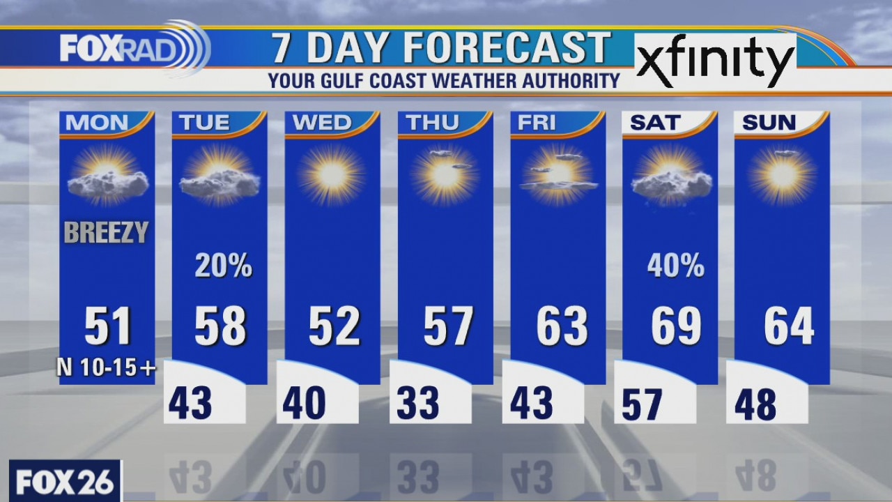
Monday weather forecast
Chilly air has filtered in behind the cold front that moved through the area on Sunday. Many communities were even able to pick up measurable rainfall as it pushed through. Temperatures will struggle to warm above 50 degrees this afternoon as clouds are expected to stick around. That north wind will also be brisk so a wind chill will definitely make temperatures feel much cooler, especially in the morning. Rain chances return on Tuesday with another cold front set to move through and reinforce the cooler air. Highs on Tuesday will approach 60 degrees before returning to the low 50s on Wednesday.
Chilly air has filtered in behind the cold front that moved through the area on Sunday. Many communities were even able to pick up measurable rainfall as it pushed through. Temperatures will struggle to warm above 50 degrees this afternoon as clouds are expected to stick around. That north wind will also be brisk so a wind chill will definitely make temperatures feel much cooler, especially in the morning. Rain chances return on Tuesday with another cold front set to move through and reinforce the cooler air. Highs on Tuesday will approach 60 degrees before returning to the low 50s on Wednesday.
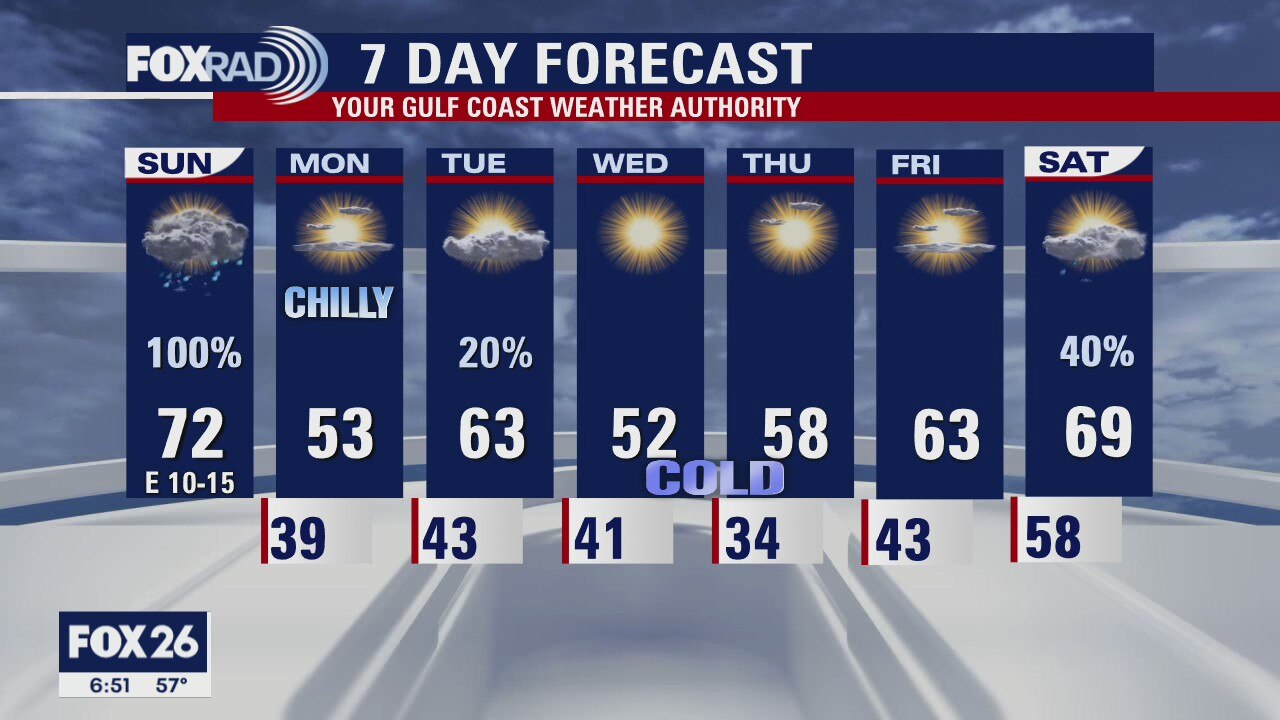
Houston-area weather forecast 12/13
Our focus today will be a cold front that will push through the region this evening. Ahead of that front, rain and storms will be likely and a few storms, especially south of I-10, could be on the strong side. Highs on Sunday will likely reach the upper 60s and low 70s. Once the front moves into the Gulf, winds will increase and temperatures will be dropping dramatically overnight. Highs on Monday will likely only warm into the low 50s after the day starts in the upper 30s! Another front will move through on Tuesday reinforcing the cold air for Wednesday and Thursday.
Our focus today will be a cold front that will push through the region this evening. Ahead of that front, rain and storms will be likely and a few storms, especially south of I-10, could be on the strong side. Highs on Sunday will likely reach the upper 60s and low 70s. Once the front moves into the Gulf, winds will increase and temperatures will be dropping dramatically overnight. Highs on Monday will likely only warm into the low 50s after the day starts in the upper 30s! Another front will move through on Tuesday reinforcing the cold air for Wednesday and Thursday.
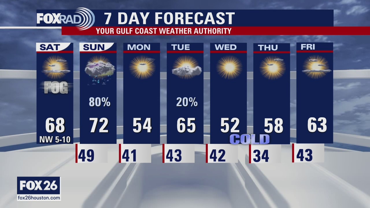
Houston-area weather forecast 12/12
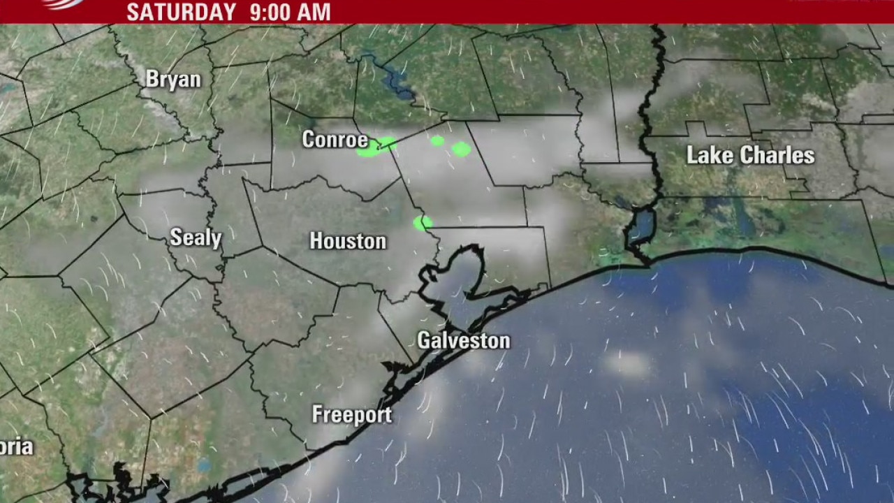
Early morning fog will dissipate and we will be on our way to a very nice Saturday. Temperatures will be more seasonable, with highs likely only reaching the upper 60s, maybe low 70s. Sunday will bring the change. While temperatures will be mild, showers are looking more and more likely throughout the day with thunderstorms possible south of I-10. There?s even a risk that a few of these storms could be severe. Once Sunday?s cold front pushes through, temperatures will be much cooler with highs only reaching the low 50s on Monday.
Early morning fog will dissipate and we will be on our way to a very nice Saturday. Temperatures will be more seasonable, with highs likely only reaching the upper 60s, maybe low 70s. Sunday will bring the change. While temperatures will be mild, showers are looking more and more likely throughout the day with thunderstorms possible south of I-10. There?s even a risk that a few of these storms could be severe. Once Sunday?s cold front pushes through, temperatures will be much cooler with highs only reaching the low 50s on Monday.
Saturday morning weather forecast
Two fronts for Houston this weekend. The first one brings rain Friday evening and cooler temperatures for Saturday. Saturday afternoon should be fantastic for any outdoor holiday activities you are trying to make happen this weekend. The second front arrives Sunday afternoon bringing rain chances again to Southeast Texas and much cooler temperatures for the start of the work week.
Two fronts for Houston this weekend. The first one brings rain Friday evening and cooler temperatures for Saturday. Saturday afternoon should be fantastic for any outdoor holiday activities you are trying to make happen this weekend. The second front arrives Sunday afternoon bringing rain chances again to Southeast Texas and much cooler temperatures for the start of the work week.
Friday Evening Weather Forecast
Two fronts for Houston this weekend. The first one brings rain Friday evening and cooler temperatures for Saturday. Saturday afternoon should be fantastic for any outdoor holiday activities you are trying to make happen this weekend. The second front arrives Sunday afternoon bringing rain chances again to Southeast Texas and much cooler temperatures for the start of the work week.
Two fronts for Houston this weekend. The first one brings rain Friday evening and cooler temperatures for Saturday. Saturday afternoon should be fantastic for any outdoor holiday activities you are trying to make happen this weekend. The second front arrives Sunday afternoon bringing rain chances again to Southeast Texas and much cooler temperatures for the start of the work week.
Friday weather forecast
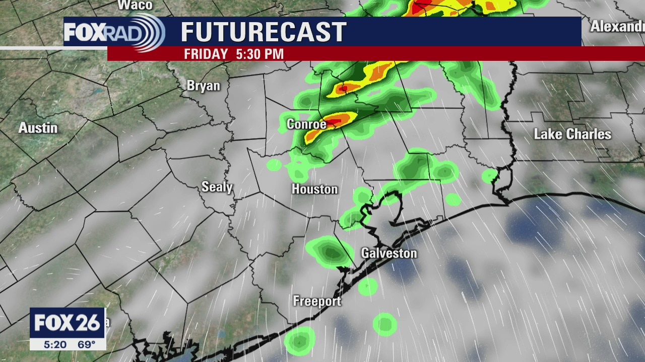
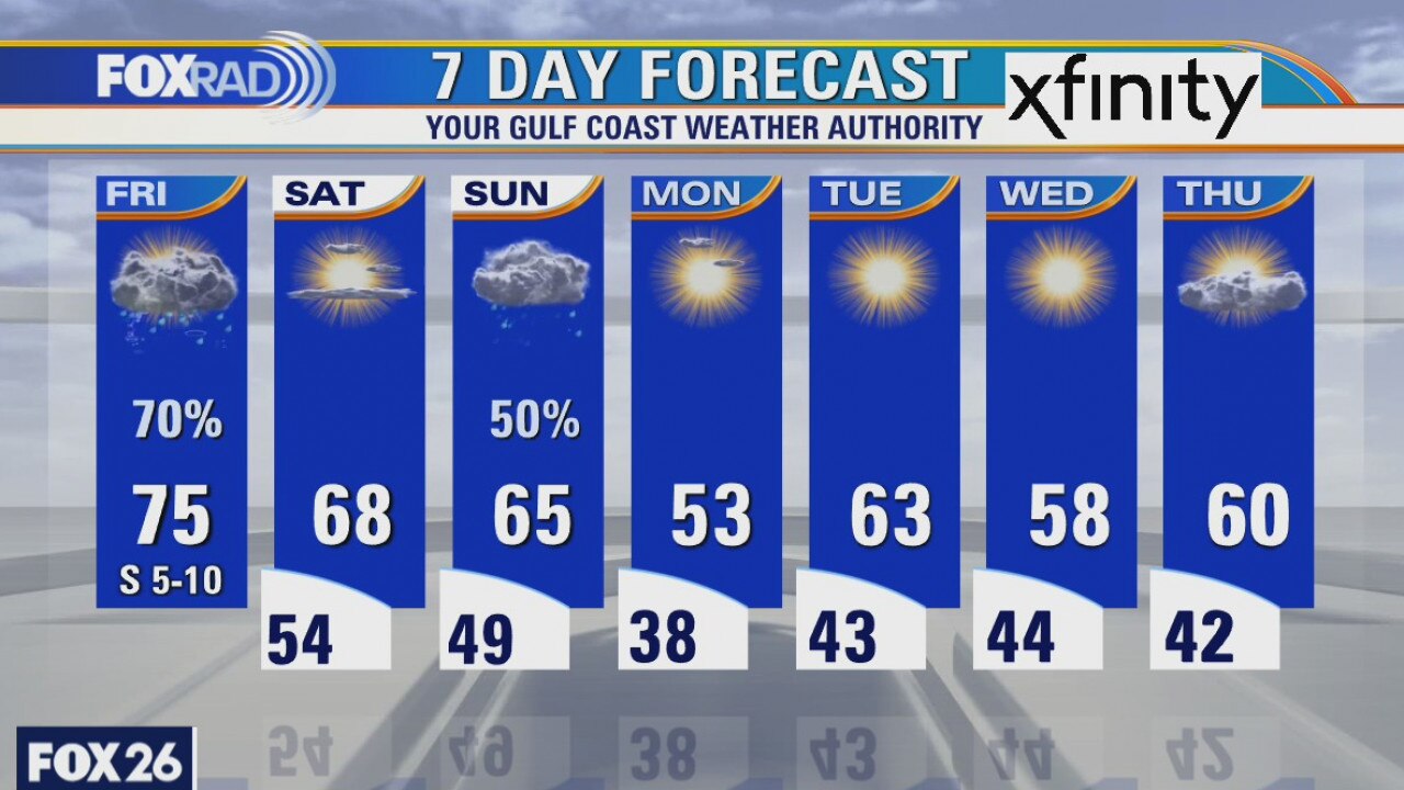
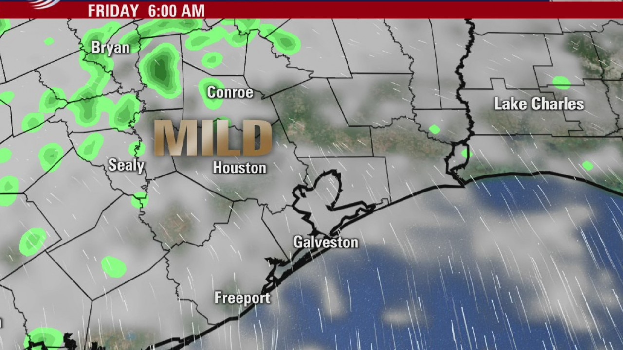
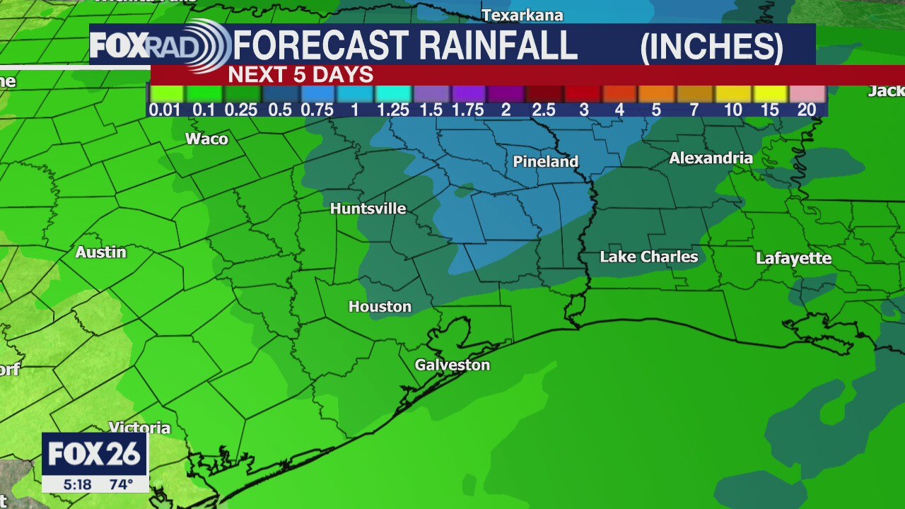
We are off to our warmest start of the week this morning with temperatures ranging from the 50s to the upper 60s! Clouds have filtered in and will be around all day. We're waiting on a cold front to arrive later this afternoon. Rain chances will be increasing, with the best chance of rain and storms between 1PM and 6PM. Storms should move out pretty quickly, but a few may produce gusty winds as they move through. Saturday is looking fantastic with highs reaching the upper 60s. The next decent shot of rain will arrive on Sunday and much cooler air is expected behind Sunday's rain.
We are off to our warmest start of the week this morning with temperatures ranging from the 50s to the upper 60s! Clouds have filtered in and will be around all day. We're waiting on a cold front to arrive later this afternoon. Rain chances will be increasing, with the best chance of rain and storms between 1PM and 6PM. Storms should move out pretty quickly, but a few may produce gusty winds as they move through. Saturday is looking fantastic with highs reaching the upper 60s. The next decent shot of rain will arrive on Sunday and much cooler air is expected behind Sunday's rain.
Friday morning weather forecast
Did you enjoy the warm weather in Houston the last several days? Changes are coming when a cold front brings the threat for rain and storms Friday afternoon. A few of these storms could bring gusty winds. Behind the front, skies clear for a short time on Saturday. Another front on Sunday will bring more rain chances and even cooler temperatures for the start of the work week.
Did you enjoy the warm weather in Houston the last several days? Changes are coming when a cold front brings the threat for rain and storms Friday afternoon. A few of these storms could bring gusty winds. Behind the front, skies clear for a short time on Saturday. Another front on Sunday will bring more rain chances and even cooler temperatures for the start of the work week.
Wednesday Evening Weather Forecast
Did you enjoy the warm weather in Houston the last several days? Changes are coming when a cold front brings the threat for rain and storms Friday afternoon. A few of these storms could bring gusty winds. Behind the front, skies clear for a short time on Saturday. Another front on Sunday will bring more rain chances and even cooler temperatures for the start of the work week.
Did you enjoy the warm weather in Houston the last several days? Changes are coming when a cold front brings the threat for rain and storms Friday afternoon. A few of these storms could bring gusty winds. Behind the front, skies clear for a short time on Saturday. Another front on Sunday will bring more rain chances and even cooler temperatures for the start of the work week.
Thursday weather forecat
A Dense Fog Advisory expired at 8AM and once the fog clears, we should warm rather quickly under a mostly sunny sky. Highs will reach the mid and upper 70s again today, but changes are set to arrive on Friday. A cold front will bring the threat for rain and storms Friday afternoon. A few of these storms could bring gusty winds. Behind the front, skies should clear for a short time on Saturday, but another round of showers will be possible on Sunday with highs struggling to get out of the 50s.
A Dense Fog Advisory expired at 8AM and once the fog clears, we should warm rather quickly under a mostly sunny sky. Highs will reach the mid and upper 70s again today, but changes are set to arrive on Friday. A cold front will bring the threat for rain and storms Friday afternoon. A few of these storms could bring gusty winds. Behind the front, skies should clear for a short time on Saturday, but another round of showers will be possible on Sunday with highs struggling to get out of the 50s.
Wednesday Evening Weather Forecast
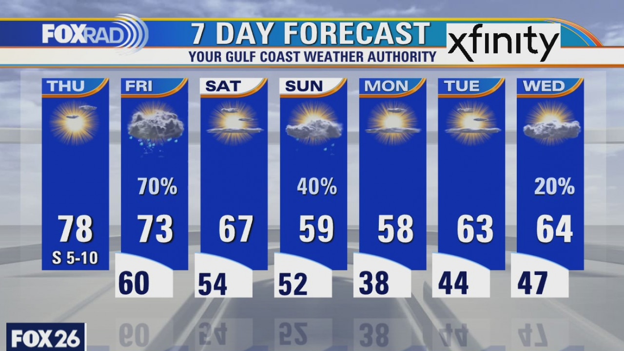
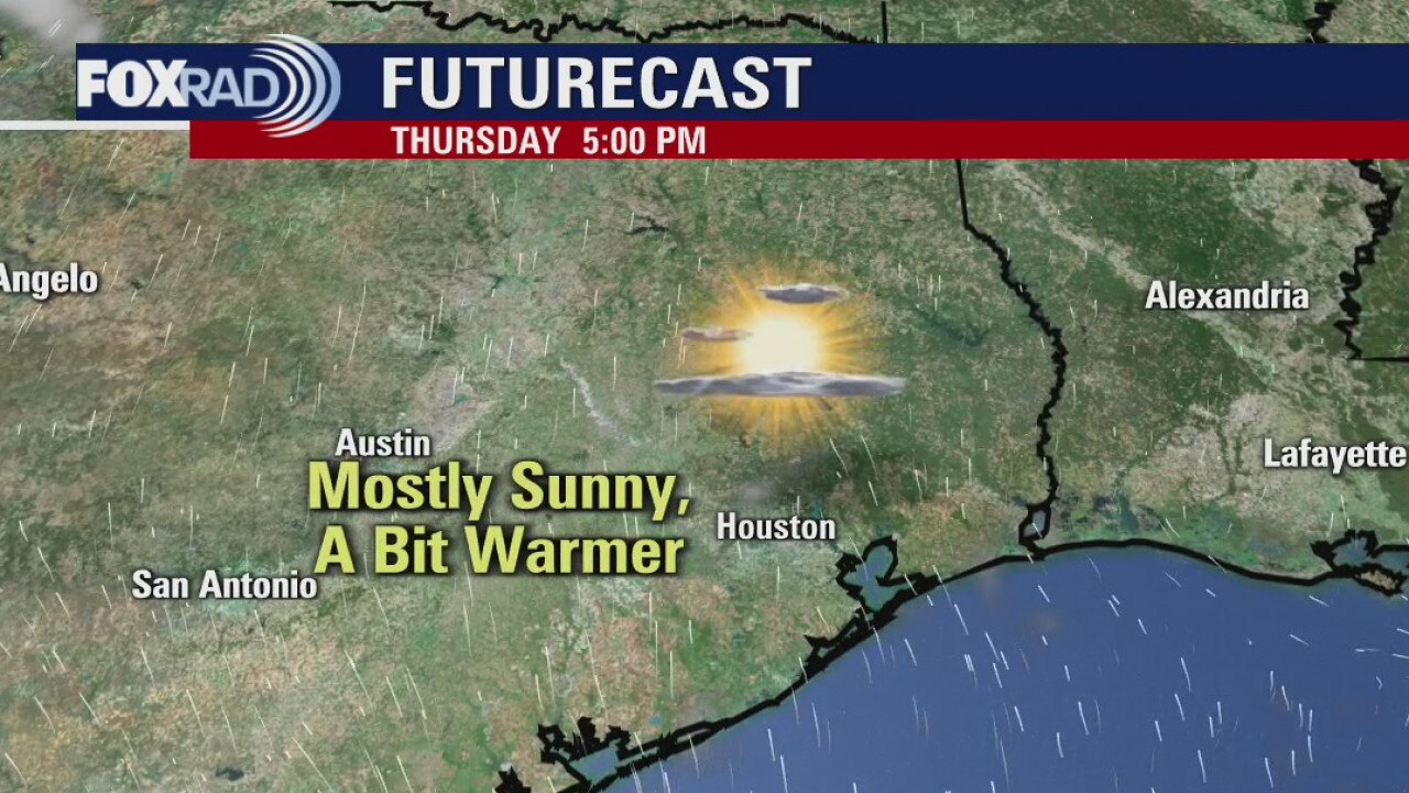
After a cool start, look for a warm afternoon on Thursday with high temperatures in the upper 70s. Two fronts this weekend will give us rain chances on Friday evening and Sunday. The second front will also come with some chilly temperatures. We will have upper 30s on Monday morning.
After a cool start, look for a warm afternoon on Thursday with high temperatures in the upper 70s. Two fronts this weekend will give us rain chances on Friday evening and Sunday. The second front will also come with some chilly temperatures. We will have upper 30s on Monday morning.

Wednesday weather forecast
Another warm up expected on Wednesday after a chilly start across the area. Some communities, closer to the coast, woke up to patches of fog, but that's quickly dissipating. It'll be another day where few, if any, clouds will be seen in our sky and highs will likely reach the mid 70s. Rain chances will not increase until Friday when a cold front is still expected to slide through the region. Thunderstorms are possible ahead and along the front and cooler temperatures will filter in behind it. Saturday and Sunday, while cooler, will also carry slight rain chances.
Another warm up expected on Wednesday after a chilly start across the area. Some communities, closer to the coast, woke up to patches of fog, but that's quickly dissipating. It'll be another day where few, if any, clouds will be seen in our sky and highs will likely reach the mid 70s. Rain chances will not increase until Friday when a cold front is still expected to slide through the region. Thunderstorms are possible ahead and along the front and cooler temperatures will filter in behind it. Saturday and Sunday, while cooler, will also carry slight rain chances.